Monongahela, Pennsylvania
Monongahela, Pennsylvania | |
|---|---|
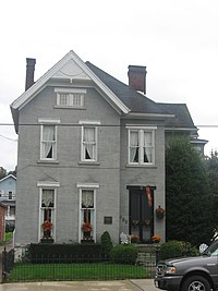
 Edward G. Acheson House | |
| Nickname: Mon City | |
 Location of Monongahela in Washington County, Pennsylvania. | |
| Coordinates: 40°12′02″N 79°55′42″W / 40.20056°N 79.92833°W | |
| Country | United States |
| State | Pennsylvania |
| County | Washington |
| Established | 1770 |
| Area | |
| • Total | 2.09 sq mi (5.40 km2) |
| • Land | 1.91 sq mi (4.95 km2) |
| • Water | 0.17 sq mi (0.45 km2) |
| Elevation | 755 ft (230 m) |
| Population | |
| • Total | 4,159 |
| • Density | 2,174.07/sq mi (839.43/km2) |
| Time zone | UTC-5 (Eastern (EST)) |
| • Summer (DST) | UTC-4 (EDT) |
| ZIP Code | 15063 |
| Area code | 724 |
| FIPS code | 42-50408 |
| Website | http://www.cityofmonongahela-pa.gov/ |
Monongahela is a city in Washington County, Pennsylvania, United States. It is part of the Pittsburgh, PA Metropolitan Statistical Area. It is 17 miles (27 km) south of Pittsburgh. The population was 4,159 at the 2020 census.[2]
References[change | change source]
- ↑ "ArcGIS REST Services Directory". United States Census Bureau. Retrieved October 12, 2022.
- ↑ 2.0 2.1 "Monongahela city, Pennsylvania". United States Census Bureau. Retrieved September 11, 2023.

