
Montour Falls, New York
Montour Falls, New York | |
|---|---|
 Downtown Montour Falls as seen from Mill Street above Shequaga Falls. | |
 Montour Falls Location within the state of New York | |
| Coordinates: 42°20′57″N 76°50′47″W / 42.34917°N 76.84639°W | |
| Country | United States |
| State | New York |
| County | Schuyler |
| Area | |
| • Total | 3.03 sq mi (7.85 km2) |
| • Land | 3.01 sq mi (7.79 km2) |
| • Water | 0.02 sq mi (0.06 km2) |
| Elevation | 449 ft (137 m) |
| Population | |
| • Total | 1,635 |
| • Density | 543.55/sq mi (209.84/km2) |
| Time zone | UTC-5 (Eastern (EST)) |
| • Summer (DST) | UTC-4 (EDT) |
| ZIP code | 14865 |
| Area code | 607 |
| FIPS code | 36-48197 |
| GNIS feature ID | 0974235 |
| Website | Village website |
Montour Falls is a village in Schuyler County, New York, United States. It had a population of 1,635 at the 2020 census.[2] It gets its name from a waterfall at the end of West Main Street. The name "Montour" comes from Queen Catharine Montour. She was a Native American woman of Seneca Indian heritage who lived at the village in the 18th century.
| Historical population | |||
|---|---|---|---|
| Census | Pop. | %± | |
| 1870 | 1,273 | — | |
| 1880 | 1,274 | 0.1% | |
| 1890 | 1,751 | 37.4% | |
| 1900 | 1,193 | −31.9% | |
| 1910 | 1,208 | 1.3% | |
| 1920 | 1,560 | 29.1% | |
| 1930 | 1,489 | −4.6% | |
| 1940 | 1,345 | −9.7% | |
| 1950 | 1,457 | 8.3% | |
| 1960 | 1,533 | 5.2% | |
| 1970 | 1,534 | 0.1% | |
| 1980 | 1,791 | 16.8% | |
| 1990 | 1,845 | 3.0% | |
| 2000 | 1,797 | −2.6% | |
| 2010 | 1,711 | −4.8% | |
| 2020 | 1,635 | −4.4% | |
| U.S. Decennial Census[3] | |||
References[change | change source]
- ↑ "ArcGIS REST Services Directory". United States Census Bureau. Retrieved September 20, 2022.
- ↑ 2.0 2.1 "Profile of General Population and Housing Characteristics: 2020 Demographic Profile Data (DP-1): Montour Falls village, New York". United States Census Bureau. Retrieved March 11, 2024.
- ↑ "Census of Population and Housing". Census.gov. Retrieved June 4, 2015.
Other websites[change | change source]
- Village of Montour Falls, NY
- Genealogy of Queen Catherine Montour
- [1] Archived 2021-12-04 at the Wayback Machine
- Schuyler Country Historical Society, Montour Falls
- Havana Stoneware Pottery Archived 2021-12-05 at the Wayback Machine
- 1,000 persons attend services honoring Charles Cook November 20, 1886
- Charles Cook founder of Schuyler County
- Charles Cook founder of Cook Academy
- Federal Reserve Bank Second District roster showing Montour National Bank (1934)
- History of Shepard Niles "Still going strong after 130 years"
Municipalities and communities of Schuyler County, New York, United States | ||
|---|---|---|
| CDPs | 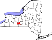 | |
| Towns | ||
| Villages | ||
| Hamlets | ||