Moray Firth
| Moray Firth | |
|---|---|
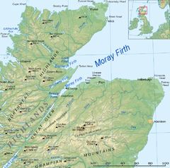
 Map of the Firth | |
| Location | Scotland, United Kingdom |
| Coordinates | 57°50′N 03°35′W / 57.833°N 3.583°W |
| Official name | Inner Moray Firth |
| Designated | 22 July 1999 |
| Reference no. | 1002[1] |
The Moray Firth is a roughly triangular inlet (or firth) of the North Sea, north and east of Inverness, which is in the Highland council area of the north of Scotland. The firth has more than 800 kilometres (about 500 miles) of coastline, much of which is cliffs. The River Ness, the River Findhorn and the River Spey all flow into it.[2]
The Caledonian Canal goes from the southern end of the firth to the west coast at Corpach near Fort William.
References[change | change source]
- ↑ "Inner Moray Firth". Ramsar Sites Information Service. Retrieved 25 April 2018.
- ↑ "Inner Moray Firth | Ramsar Sites Information Service". rsis.ramsar.org. Retrieved 2023-08-07.

