
Mount Haguro
| Mount Haguro (羽黒山, Haguro-san) | |
|---|---|
 The Gojū-tō Pagoda | |
| Religion | |
| Affiliation | Shinto |
| Location | |
 Shown within Japan | |
| Geographic coordinates | 38°42′09″N 139°58′58″E / 38.70250°N 139.98278°E |
Mount Haguro (羽黒山, Haguro-san), is a mountain in the city of Tsuruoka. It was part of the ancient province of Dewa in Japan. It is one of the Three Mountains of Dewa and stands at 414 meters (1,358 feet), making it the shortest of the three. However, unlike the other two mountains, it is accessible throughout the year. It has the famous Dewa Shrine on it.
There is a path that has 2,446 stone steps leading to its summit.[1] The mountain has 600-year-old sugi trees, and along the way to the top, you will see famous landmarks like the Gojūnotō five-story pagoda, Grandpa cedar (jijisugi 爺杉), a 1000-year-old cedar tree, and many shrines. The steps and the pagoda are important and are listed as National Treasures. At the summit of the mountain is the Sanjingōsaiden shrine (三神合祭殿), which honors the spirits of all three mountains.
You can also reach the summit of the mountain by bus service. Besides religious pilgrims, travelers often stay at the Saikan temple lodgings.
In the Edo period there used to be 336 shukubo on the mountain[2]
Gallery[change | change source]
-
-
 Sanzan Gosai-den temple
 -
 Gosai-den-haiden
 -
 Gojū-tō
 -
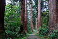 The path to the summit
 -
 Haniyamahime-jinja
 -
 The Gojū-tō Pagoda, near the base of Mount Haguro
 -
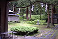 The grounds of the Saikan lodgings.
 -
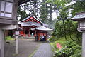
 A temple at the top of Mount Haguro.
 -
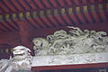 Detailed engraving work on top of a temple.
 -
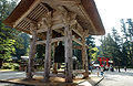
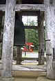 Bell and torii
 -
 Incense
 -
 Sculpture
 -
 The path to the summit


References[change | change source]
- ↑ "Mt. Haguro - Japan National Tourism Organization". Retrieved 2017-06-26.
- ↑ Earhart, H. B. (1965). Four Ritual Periods of Haguro Shugendō in Northeastern Japan. History of Religions, 5(1), 93–113. http://www.jstor.org/stable/1061805