Mount Royal
| Mount Royal | |
|---|---|
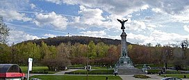
 George-Étienne Cartier Monument and Mount Royal's eastern slope | |
| Highest point | |
| Elevation | 233 m (764 ft) |
| Prominence | 227 m (745 ft) |
| Isolation | 32.68 km (20.31 mi) |
| Coordinates | 45°30′23″N 73°35′20″W / 45.50639°N 73.58889°W |
| Geography | |
Montréal, Quebec, Canada | |
| Parent range | Monteregian Hills |
| Topo map | NTS Template:Canada NTS Map Sheet |
| Geology | |
| Age of rock | Early Cretaceous |
| Mountain type | Intrusive stock |
| Climbing | |
| First ascent | Jacques Cartier, 1535 (first European) |
| Easiest route | Hiking or Cycling |
Mount Royal (French: Mont Royal, IPA: [mɔ̃ ʁwajal]) is a small volcano in the city of Montreal,. The name of the city may come from the name of this hill.
This volcano is part of the Monteregian Hills, between the Lauretians and Appalachian Mountains,[1] The hill has three peaks: Colline de la Croix, Colline d'Outremont and Westmount Summit, Colline de la Croix is an active caldera.[2]
References[change | change source]
- ↑ A Hundred-Million Year History of the Corner Rise and New England Seamounts. Retrieved 1 August 2007
- ↑ Origine du Mont-Royal. Retrieved November 3rd 2020

