Norfolk County, Massachusetts
Norfolk County | |
|---|---|
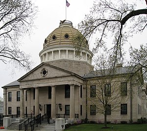
 Norfolk County Courthouse in Dedham | |
| Motto(s): Antiquity, Perseverance, History, Industry | |
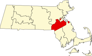
 Location within the U.S. state of Massachusetts | |
 Massachusetts's location within the U.S. | |
| Coordinates: 42°11′57″N 71°09′16″W / 42.199158°N 71.154442°W | |
| Country | |
| State | |
| Founded | 1793 |
| Named for | Norfolk |
| Seat | Dedham |
| Largest city | Quincy |
| Area | |
| • Total | 444 sq mi (1,150 km2) |
| • Land | 396 sq mi (1,030 km2) |
| • Water | 48 sq mi (120 km2) 11% |
| Population (2020) | |
| • Total | 725,981 |
| • Density | 1,833/sq mi (708/km2) |
| Time zone | UTC−5 (Eastern) |
| • Summer (DST) | UTC−4 (EDT) |
| Congressional districts | 2nd, 4th, 7th, 8th |
| Website | www |
Norfolk County is a county in the U.S. state of Massachusetts. As of the 2020 census, the population was 725,981.[1] The county seat is Dedham.[2] The county was named after the English county of the same name.[3] Two towns, Cohasset and Brookline, are exclaves. It is the richest county in Massachusetts.
Norfolk County was created on March 26, 1793.
References[change | change source]
- ↑ "QuickFacts: Norfolk County, Massachusetts". United States Census Bureau. Retrieved January 3, 2024.
- ↑ "Find a County". National Association of Counties. Retrieved June 7, 2011.
- ↑ Thomas Cox, Anthony Hall, Robert Morden, Magna Britannia Antiqua & Nova: Or, A New, Exact, and Comprehensive Survey of the Ancient and Present State of Great Britain, Volume 5, (Caesar Ward and Richard Chandler: London, 1738), pg. 171 (accessed on Google Book Search, June 22, 2008)
Other websites[change | change source]
Wikimedia Commons has media related to Norfolk County, Massachusetts.


