North Canton, Ohio
North Canton, Ohio | |
|---|---|
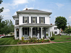
 Hoover Historical Center | |
| Nickname: The Dogwood City | |
 Location of North Canton, Ohio | |
 Location of North Canton in Stark County | |
| Coordinates: 40°52′30″N 81°23′50″W / 40.87500°N 81.39722°W | |
| Country | United States |
| State | Ohio |
| County | Stark |
| Area | |
| • Total | 6.40 sq mi (16.57 km2) |
| • Land | 6.40 sq mi (16.57 km2) |
| • Water | 0.00 sq mi (0.00 km2) |
| Elevation | 1,129 ft (344 m) |
| Population | |
| • Total | 17,842 |
| • Density | 2,788.25/sq mi (1,076.50/km2) |
| Time zone | UTC-5 (Eastern (EST)) |
| • Summer (DST) | UTC-4 (EDT) |
| ZIP codes | 44709, 44720, 44799 |
| Area code | 330 |
| FIPS code | 39-56294[4] |
| GNIS feature ID | 2395252[2] |
| Website | northcantonohio |
North Canton is a city in Stark County, Ohio, United States. The population was 17,842 at the 2020 census.[3]
Demographics[change | change source]
| Historical population | |||
|---|---|---|---|
| Census | Pop. | %± | |
| 1910 | 865 | — | |
| 1920 | 1,597 | 84.6% | |
| 1930 | 2,648 | 65.8% | |
| 1940 | 2,988 | 12.8% | |
| 1950 | 4,032 | 34.9% | |
| 1960 | 7,727 | 91.6% | |
| 1970 | 15,228 | 97.1% | |
| 1980 | 14,189 | −6.8% | |
| 1990 | 14,748 | 3.9% | |
| 2000 | 16,369 | 11.0% | |
| 2010 | 17,488 | 6.8% | |
| 2020 | 17,842 | 2.0% | |
| Sources:[3][4][5][6] | |||
References[change | change source]
- ↑ "ArcGIS REST Services Directory". United States Census Bureau. Retrieved September 20, 2022.
- ↑ 2.0 2.1 U.S. Geological Survey Geographic Names Information System: North Canton, Ohio
- ↑ 3.0 3.1 3.2 "QuickFacts: North Canton city, Ohio". United States Census Bureau. Retrieved March 15, 2024.
- ↑ 4.0 4.1 "U.S. Census website". United States Census Bureau. Retrieved January 31, 2008.
- ↑ "Number of Inhabitants: Ohio" (PDF). 18th Census of the United States. U.S. Census Bureau. 1960. Retrieved May 17, 2020.
- ↑ "Ohio: Population and Housing Unit Counts" (PDF). U.S. Census Bureau. Retrieved November 22, 2013.
