
Oakley, Kansas
Oakley, Kansas | |
|---|---|
City and County seat | |
 Gas station on US Route 40 near I-70 (2011) | |
 Location within Logan County and Kansas | |
 | |
| Coordinates: 39°7′41″N 100°51′16″W / 39.12806°N 100.85444°W[1] | |
| Country | United States |
| State | Kansas |
| Counties | Logan, Thomas, Gove |
| Founded | 1884 |
| Incorporated | 1887 |
| Named for | Elizabeth Oakley Gardner Hoag |
| Area | |
| • Total | 1.92 sq mi (4.98 km2) |
| • Land | 1.92 sq mi (4.98 km2) |
| • Water | 0.00 sq mi (0.00 km2) |
| Elevation | 3,051 ft (930 m) |
| Population | |
| • Total | 2,046 |
| • Density | 1,100/sq mi (410/km2) |
| Time zone | UTC-6 (CST) |
| • Summer (DST) | UTC-5 (CDT) |
| ZIP code | 67748 |
| Area code | 785 |
| FIPS code | 20-51825 [1] |
| GNIS ID | 2395293[1] |
| Website | discoveroakley.com |
Oakley is a city in Gove, Logan, and Thomas counties in the U.S. state of Kansas. It is also the county seat of Logan County.[4] In 2020, 2,046 people lived there.[3]
History[change | change source]
The area that would become Oakley was settled in the 1870s and 1880s by people on the Smoky Hill Trail. Oakley was created in 1884 by Judge Fredman and David D. Hoag. It was first named Carlyle. Its name was changed to Cleveland. The name changed again to Oakley in 1885. It was named after Hoag's mother, Elizabeth Oakley Gardner Hoag.[5]
Geography[change | change source]
Oakley is at 39°7′41″N 100°51′16″W / 39.12806°N 100.85444°W (39.128023, -100.854490). It has an elevation of 3,064 feet (934 m).[6][7] It is about 1 mile (1.6 km) south of the South Fork of the Saline River in the High Plains region of the Great Plains.
The city is at the intersection of Interstate 70, U.S. Route 40, and U.S. Route 83 in northwest Kansas. It is in the northeast corner of Logan County, and portions of it extend into Gove County and Thomas County. Oakley is about 211 miles (340 km) northwest of Wichita, 227 miles east-southeast of Denver, and 335 miles (539 km) west of Kansas City.[8]
The United States Census Bureau says that the city has a total area of 1.92 square miles (4.98 km2). All of it is land.[2]
Climate[change | change source]
Oakley has hot, humid summers and generally mild to cool winters. The Köppen Climate Classification system says that Oakley has a humid continental climate, abbreviated "Dfa" on climate maps.[9]
People[change | change source]
| Historical population | |||
|---|---|---|---|
| Census | Pop. | %± | |
| 1890 | 176 | — | |
| 1900 | 269 | 52.8% | |
| 1910 | 681 | 153.2% | |
| 1920 | 768 | 12.8% | |
| 1930 | 1,159 | 50.9% | |
| 1940 | 1,138 | −1.8% | |
| 1950 | 1,915 | 68.3% | |
| 1960 | 2,190 | 14.4% | |
| 1970 | 2,327 | 6.3% | |
| 1980 | 2,343 | 0.7% | |
| 1990 | 2,045 | −12.7% | |
| 2000 | 2,173 | 6.3% | |
| 2010 | 2,045 | −5.9% | |
| 2020 | 2,046 | 0.0% | |
| U.S. Decennial Census | |||
2020 census[change | change source]
The 2020 census says that there were 2,046 people, 896 households, and 540 families living in Oakley. Of the households, 68.3% owned their home and 31.7% rented their home.
The median age was 40.1 years. Of the people, 90.0% were White, 0.5% were Asian, 0.1% were Black, 0.1% were Pacific Islanders, 3.9% were from some other race, and 5.4% were two or more races. Hispanic or Latino of any race were 8.3% of the people.[3][10]
2010 census[change | change source]
The 2010 census says that there were 2,045 people, 920 households, and 562 families living in Oakley.[11]
Media[change | change source]
The Oakley Graphic is the local newspaper. It is published once per week. The first edition of the newspaper was published on November 22, 1889.[12]
References[change | change source]
- ↑ 1.0 1.1 1.2 1.3 U.S. Geological Survey Geographic Names Information System: Oakley, Kansas
- ↑ 2.0 2.1 "2020 U.S. Gazetteer Files". United States Census Bureau. Retrieved December 11, 2023.
- ↑ 3.0 3.1 3.2 "DP1: PROFILE OF GENERAL POPULATION AND HOUSING CHARACTERISTICS". United States Census Bureau. Retrieved December 11, 2023.
- ↑ "Find a County". National Association of Counties. Archived from the original on May 31, 2011. Retrieved 2011-06-07.
- ↑ "History of Oakley". City of Oakley, Kansas. Retrieved September 15, 2018.
- ↑ "US Board on Geographic Names". United States Geological Survey. 2007-10-25. Retrieved 2008-01-31.
- ↑ "US Gazetteer files: 2010, 2000, and 1990". United States Census Bureau. 2011-02-12. Retrieved 2011-04-23.
- ↑ "City Distance Tool". Geobytes. Archived from the original on 2010-10-05. Retrieved 2010-05-22.
- ↑ Climate Summary for Oakley, Kansas
- ↑ "P16: HOUSEHOLD TYPE". United States Census Bureau. Retrieved January 2, 2024.
- ↑ "American FactFinder". United States Census Bureau. Retrieved 2012-07-06.
- ↑ "About this Newspaper: The Oakley graphic". Chronicling America. Library of Congress. Retrieved 2009-09-27.
Other websites[change | change source]
- City
- Schools
- USD 274, local school system
- Historical
- Fick Museum
- Historic Images - Wichita State University Libraries
- Maps
- Oakley City Map, KDOT
- Other
- Palace Community Theatre Archived 2018-08-24 at the Wayback Machine
Municipalities and communities of Gove County, Kansas, United States | ||
|---|---|---|
| Cities | 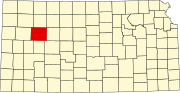 | |
| Ghost towns | ||
| Townships | ||
| Footnotes | ‡This community also has portions in an adjacent county or counties. | |
Municipalities and communities of Logan County, Kansas, United States | ||
|---|---|---|
| Cities |  | |
| Unincorporated communities | ||
| Ghost towns | ||
| Footnotes | †This community is designated a Census-Designated Place (CDP) by the United States Census Bureau. ‡This community also has portions in an adjacent county or counties. | |
Municipalities and communities of Thomas County, Kansas, United States | ||
|---|---|---|
| Cities | 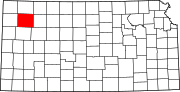 | |
| CDP | ||
| Unincorporated communities | ||
| Ghost towns | ||
| Footnotes | ‡This populated place also has portions in an adjacent county or counties | |
| International | |
|---|---|
| National | |