
Paysandú Department
Paysandú | |
|---|---|
 Old custom office in the old port in Paysandú. | |
 Flag  Coat of arms | |
 Location of Paysandú, in red, in Uruguay | |
| Coordinates: 30°3′55″S 57°19′38″W / 30.06528°S 57.32722°W | |
| Country | |
| Creation | 27 January 1816 |
| Capital | Paysandú |
| Government | |
| • Intendant | Guillermo Caraballo[1] |
| Area | |
| • Total | 13,922 km2 (5,375 sq mi) |
| Population (2011)[2] | |
| • Total | 113,124 |
| • Density | 8.1/km2 (21/sq mi) |
| Time zone | UTC-03 (UYT) |
| ISO 3166 code | UY-PA |
| Website | Official website |
The Paysandú department (Spanish: Departamento de Paysandú) is a department of Uruguay. The capital is the city of Paysandú.
Its ISO 3166-2 code is UY-PA.
Geography[change | change source]

The Paysandú department is in the western part of Uruguay, along the Uruguay river. It has an area of 13,922 km2 (5,375 sq mi), the third largest department in the country, after the Tacuarembó and Salto departments. The population is 113,124 inhabitants (2011 census) for a population density of 8.1 inhabitants/km2.
There are two chains of low hills in the department. These chains of low and rounded hills are named cuchillas in the country. The two cuchillas in the department are cuchilla de Queguay to the northwest, and cuchilla de Haedo to the southeast.
There is one protected area in the department: Montes del Queguay (Spanish: Área protegida Montes del Queguay); it is around the confluence of the Queguay Grande and Queguay Chico rivers.
Limits[change | change source]
Places next to Paysandú Department | ||||||||||
|---|---|---|---|---|---|---|---|---|---|---|
| ||||||||||
Rivers[change | change source]
The main rivers in the department are:
- Uruguay, to the west and that forms the border with Argentina; and
- Queguay Grande, a tributary of the Uruguay river that flows through the department from East to West.
Climate[change | change source]
The Köppen climate classification type for the climate in Paysandú is a "Humid subtropical climate" and of the subtype Cfa.[3]
The average amount of precipitation for the year in Paysandú is 1,196.3 mm (47.1 in). The month with the most precipitation on average is March with 142.2 mm (5.6 in) of precipitation. The month with the least precipitation on average is May with an average of 66 mm (2.6 in).
The average temperature for the year in Paysandú is 17.9 °C (64.2 °F). The warmest month, on average, is January with an average temperature of 24.8 °C (76.6 °F). The coolest month on average is June, with an average temperature of 11.7 °C (53.1 °F).
Demographics[change | change source]
The inhabitants of the Paysandú department (and of the city of Paysandú) are known, in Spanish, as Sanduceros.
Evolution of the population in Paysandú

- Rural population
According to the 2011 census, the Paysandú department has a rural population of 4,364.[2]
- Main towns
| City / Town | Population (2011) |
|---|---|
| Paysandú | 76,412 |
| Nuevo Paysandú | 8,578 |
| Guichón | 5,039 |
| Chacras de Paysandú | 3,965 |
| Quebracho | 2,853 |
| San Félix | 1,718 |
| Porvenir | 1,159 |
| Tambores | 1,111 |
| Piedras Coloradas | 1,094 |
Gallery[change | change source]
-
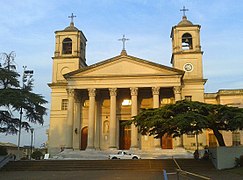 Basilica of Paysandú.
 -
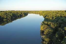 Queguay Grande river.
 -
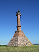 Plateau of Artigas.
 -
 Montes del Queguay.


Related pages[change | change source]
References[change | change source]
- ↑ "Intendente" (in Spanish). Intendencia Departamental de Paysandú. Archived from the original on 25 July 2017. Retrieved 5 August 2017.
- ↑ 2.0 2.1 "Censos 2011 - Departamento Paysandú". Instituto Nacional de Estadística. 10 August 2012. Archived from the original on 6 August 2016. Retrieved 20 July 2017.
- ↑ "Paysandú, Uruguay - Köppen Climate Classification". Weatherbase. Retrieved 5 August 2017.
Other websites[change | change source]
- Intendencia Departamental de Paysandú website (in Spanish)
- Statoids - Departments of Uruguay
- Enciclopedia Geográfica del Uruguay: Paysandú (in Spanish)
| National | |
|---|---|
| Geographic | |