
Polksville, Kentucky
Polksville, Kentucky | |
|---|---|
 Polksville, Kentucky | |
| Coordinates: 38°08′18″N 83°39′15″W / 38.13833°N 83.65417°W | |
| Country | United States |
| State | Kentucky |
| County | Bath |
| Elevation | 705 ft (215 m) |
| Time zone | UTC-5 (Eastern (EST)) |
| • Summer (DST) | UTC-4 (EDT) |
| Area code | 606 |
| GNIS feature ID | 514678[1] |
Polksville is an unincorporated community in Bath County, Kentucky, United States. Polksville is on U.S. Route 60. It is 2.5 miles (4.0 km) northwest of Salt Lick.
References[change | change source]
- ↑ "US Board on Geographic Names". United States Geological Survey. 2007-10-25. Retrieved 2008-01-31.
Municipalities and communities of Bath County, Kentucky, United States | ||
|---|---|---|
| Cities | 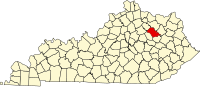 | |
| Unincorporated communities | ||