
Pottenstein, Bavaria
Pottenstein | |
|---|---|
 | |
 Coat of arms | |
Location of Pottenstein within Bayreuth district  | |
 Pottenstein  Pottenstein | |
| Coordinates: 49°46′20″N 11°24′41″E / 49.77222°N 11.41139°E | |
| Country | Germany |
| State | Bavaria |
| Admin. region | Oberfranken |
| District | Bayreuth |
| Subdivisions | 32 Ortsteile |
| Government | |
| • Mayor (2020–26) | Stefan Frühbeißer[1] |
| Area | |
| • Total | 73.24 km2 (28.28 sq mi) |
| Elevation | 368 m (1,207 ft) |
| Population (2022-12-31)[2] | |
| • Total | 5,263 |
| • Density | 72/km2 (190/sq mi) |
| Time zone | UTC+01:00 (CET) |
| • Summer (DST) | UTC+02:00 (CEST) |
| Postal codes | 91278 |
| Dialling codes | 09243 |
| Vehicle registration | BT |
| Website | www.pottenstein.de |
Pottenstein is a town in the district of Bayreuth, in Bavaria, Germany. It is 23 km southwest of Bayreuth, and 26 km east of Forchheim.
Gallery[change | change source]
-
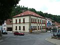 City Hall in Pottenstein
 -
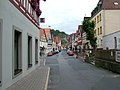 Main Street in Pottenstein
 -
 Pottenstein Castle
 -
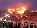 Yearly resolution of the Eternal Adoration (The Festival of Lights)


References[change | change source]
- ↑ Liste der ersten Bürgermeister/Oberbürgermeister in kreisangehörigen Gemeinden, Bayerisches Landesamt für Statistik, 15 July 2021.
- ↑ Genesis Online-Datenbank des Bayerischen Landesamtes für Statistik Tabelle 12411-003r Fortschreibung des Bevölkerungsstandes: Gemeinden, Stichtag (Einwohnerzahlen auf Grundlage des Zensus 2011)
Other websites[change | change source]
Wikivoyage has a travel guide about: Pottenstein (Oberfranken)
Towns and municipalities in Bayreuth (district) | ||
|---|---|---|
|  | |
| International | |
|---|---|
| National | |
| Geographic | |