Saint-Jean-d'Angély
Saint-Jean-d'Angély | |
|---|---|
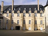
 Historic centre of Saint-Jean-d'Angély | |
| Coordinates: 45°56′48″N 0°31′46″W / 45.9466°N 0.5294°W | |
| Country | France |
| Region | Nouvelle-Aquitaine |
| Department | Charente-Maritime |
| Arrondissement | Saint-Jean-d'Angély |
| Canton | Saint-Jean-d'Angély |
| Intercommunality | Vals de Saintonge |
| Government | |
| • Mayor | Françoise Mesnard[1] |
| Area 1 | 18.78 km2 (7.25 sq mi) |
| Population (2014) | 7,123 |
| • Density | 380/km2 (980/sq mi) |
| Time zone | UTC+01:00 (CET) |
| • Summer (DST) | UTC+02:00 (CEST) |
| INSEE/Postal code | 17347 /17400 |
| Elevation | 8–76 m (26–249 ft) (avg. 42 m or 138 ft) |
| Website | www.angely.net |
| 1 French Land Register data, which excludes lakes, ponds, glaciers > 1 km2 (0.386 sq mi or 247 acres) and river estuaries. | |
Saint-Jean-d'Angély is a French commune, a subprefecture in the Charente-Maritime department in southwestern France. It is in the Nouvelle-Aquitaine region. It is also the capital of the arrondissement of Saint-Jean-d'Angély.
The commune has its historical origins in the Abbey of Saint-Jean-d'Angély.
Geography[change | change source]
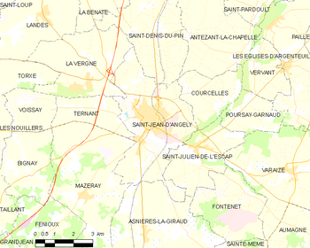
Saint-Jean-d'Angély is in the northeast of the Charente-Maritime department, in the old province of Saintonge, along the Boutonne river, a tributary of the Charente river.
The commune of Saint-Jean-d'Angély has an area of 18.8 km2 (7.3 sq mi),[2] and its average altitude is 42 m (138 ft); at the city hall, the altitude is 20 m (66 ft).[3]
| Bordeaux | Toulouse | Montpellier | Lyon | Nantes | Paris | Marseille |
|---|---|---|---|---|---|---|
| 148 km (92 mi) | 384 km (239 mi) | 622 km (386 mi) | 580 km (360 mi) | 211 km (131 mi) | 447 km (278 mi) | 787 km (489 mi) |

|
The commune of Saint-Jean-d'Angély is surrounded by the communes:
Climate[change | change source]
The climate of Saint-Jean-d'Angély, in the Köppen climate classification, is Cfb - Oceanic climate with template summers.
Population[change | change source]
The inhabitants of this city are known, in French, as Angériens (women: Angériennes).[4]
With a population of 7,123,[5] Saint-Jean-d'Angély has a population density of 379 inhabitants/km2.
Evolution of the population in Saint-Jean-d'Angély

Administration[change | change source]
Saint-Jean-d'Angély is a subprefecture of the Charente-Maritime department, the capital of the arrondissement of Saint-Jean-d'Angély and the administrative centre (French: chef-lieu) of the canton of Saint-Jean-d'Angély.
It is part of the intercommunality Vals de Saintonge (French: Communauté de communes des Vals de Saintonge).
Twinned and partner towns[change | change source]
Saint-Jean-d'Angély is twinned with:
Gallery[change | change source]
Related pages[change | change source]
References[change | change source]
- ↑ "La Mairie - Les élus du Conseil Municipal" (in French). La ville d'Ussel. Retrieved 9 July 2016.
- ↑ "Commune de Saint-Jean-d'Angély (17347) - Comparateur de territoire". Publications et statistiques pour la France ou les régions (in French). Institut national de la statistique et des études économiques - INSEE. Retrieved 28 May 2017.
- ↑ "City of Saint-Jean-d'Angély". Map-France.com. Retrieved 28 May 2017.
- ↑ "Charente-Maritime" (in French). habitants.fr. Retrieved 28 May 2017.
- ↑ "Régions, départements, arrondissements, cantons et communes" (PDF). Populations légales 2014 (in French). Institut national de la statistique et des études économiques - INSEE. Retrieved 28 May 2017.
Other websites[change | change source]
- Mairie de Saint-Jean-d'Angély website (in French)


