Seattle–Tacoma International Airport
Seattle–Tacoma International Airport | |||||||||||||||||||
|---|---|---|---|---|---|---|---|---|---|---|---|---|---|---|---|---|---|---|---|
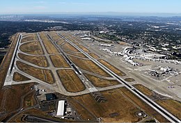
 Sea–Tac Airport in August 2012, looking north | |||||||||||||||||||
| Summary | |||||||||||||||||||
| Airport type | Public | ||||||||||||||||||
| Owner/Operator | Port of Seattle | ||||||||||||||||||
| Serves | Seattle metropolitan area | ||||||||||||||||||
| Location | SeaTac, Washington, U.S. | ||||||||||||||||||
| Hub for | |||||||||||||||||||
| Elevation AMSL | 433 ft / 132 m | ||||||||||||||||||
| Coordinates | 47°26′56″N 122°18′34″W / 47.44889°N 122.30944°W | ||||||||||||||||||
| Website | flysea.org | ||||||||||||||||||
| Maps | |||||||||||||||||||
 FAA diagram | |||||||||||||||||||
| Runways | |||||||||||||||||||
| |||||||||||||||||||
| Statistics (2019) | |||||||||||||||||||
| |||||||||||||||||||
Seattle–Tacoma International Airport (IATA: SEA, ICAO: KSEA, FAA LID: SEA), also called Sea–Tac Airport or Sea–Tac (/ˈsiːtæk/), is the airport in SeaTac, Washington for Seattle, Washington. It is 13 miles (21 km) south of downtown Seattle. The airport is the biggest in the Pacific Northwest and has many airlines, like Alaska Airlines and Delta Air Lines. It has three runways and three terminals.
Airlines[change | change source]
- Aer Lingus
- Aeroméxico
- Air Canada and Air Canada Express
- Air France
- Alaska Airlines (hub)
- All Nippon Airways
- American Airlines and American Eagle
- Asiana Airlines
- British Airways
- Cathay Pacific
- Condor Flugdienst
- Delta Air Lines and Delta Connection (hub)
- Emirates
- Eurowings
- EVA Air
- Frontier Airlines
- Hainan Airlines
- Hawaiian Airlines
- Icelandair
- Japan Airlines
- JetBlue Airways
- Korean Air
- Lufthansa
- Norwegian Air Shuttle
- Singapore Airlines
- Southwest Airlines
- Spirit Airlines
- Sun Country Airlines
- Thomas Cook Airlines
- United Airlines and United Express
- Virgin Atlantic
- Volaris
- XiamenAir
References[change | change source]
- ↑ FAA Airport Master Record for SEA (Form 5010 PDF), effective July 5, 2007.
- ↑ "Sea–Tac international airport". Port of Seattle. Archived from the original on October 17, 2015. Retrieved October 18, 2015. (official site)


