Setagaya
(Redirected from Setagaya, Tokyo)
Setagaya
世田谷区 | |
|---|---|
| City of Setagaya | |
 | |
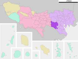
 Location of Setagaya in Tokyo | |
| Coordinates: 35°38′47.66″N 139°39′11.69″E / 35.6465722°N 139.6532472°E | |
| Country | Japan |
| Region | Kantō |
| Prefecture | Tokyo |
| First official recorded | middle 15th century |
| As Tokyo City | October 1, 1932 |
| As Special word of Tokyo | July 1, 1943 |
| Government | |
| • Mayor | Nobuto Hosaka (since May 2011) |
| Area | |
| • Total | 58.06 km2 (22.42 sq mi) |
| Population (January 1, 2020) | |
| • Total | 939,099 |
| • Density | 16,000/km2 (42,000/sq mi) |
| Time zone | UTC+09:00 (JST) |
| Postal code(s) | 154 to 158 (First three digits) |
| Area code | 03 |
| Website | www |
| Symbols | |
| Bird | Azure-winged magpie |
| Flower | Habenaria radiata |
| Tree | Zelkova serrata |
Setagaya (Japanese: 世田谷区) is a special ward in Tokyo, Japan.
Company[change | change source]


