
Shawbury
| Shawbury | |
|---|---|
 The Elephant and Castle public house, Shawbury | |
 Shawbury | |
| Location within Shropshire | |
| Population | 2,872 (2011 census) |
| OS grid reference | SJ550210 |
| Civil parish |
|
| Unitary authority | |
| Ceremonial county | |
| Region | |
| Country | England |
| Sovereign state | United Kingdom |
| Post town | SHREWSBURY |
| Postcode district | SY4 |
| Dialling code | 01939 |
| Police | West Mercia |
| Fire | Shropshire |
| Ambulance | West Midlands |
| UK Parliament | |
Shawbury is a village and civil parish in Shropshire, England. It is 8.4 miles (13.5 km) north east of Shrewsbury, the county town, 11.5 miles (18.5 km) north west of Telford and 163 miles (262 km) north west of London. The 2011 census revealed the parish had 2,872 residents.
The village is recorded in the 1085 Domesday Book. In the book, it is called Sawesberie.
The A53 between Shrewsbury and Market Drayton goes through the village.
The village has a Co-operative shop, a pub, a church, a chip shop and a Chinese takeaway.
It is home to RAF Shawbury, a Royal Air Force base.
Gallery[change | change source]
-
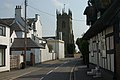 Church Street
 -
 RAF Shawbury
 -
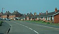 Houses in Shawbury


