Shoshone County, Idaho
Shoshone County | |
|---|---|
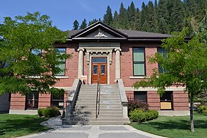
 Wallace Carnegie Library | |
 Location within the U.S. state of Idaho | |
 Idaho's location within the U.S. | |
| Coordinates: 47°21′N 115°53′W / 47.35°N 115.89°W | |
| Country | |
| State | |
| Founded | February 4, 1864 |
| Named for | Shoshone tribe |
| Seat | Wallace |
| Largest city | Kellogg |
| Area | |
| • Total | 2,635 sq mi (6,820 km2) |
| • Land | 2,630 sq mi (6,800 km2) |
| • Water | 5.5 sq mi (14 km2) 0.2% |
| Population (2020) | |
| • Total | 13,169 |
| • Density | 5.0/sq mi (1.9/km2) |
| Time zone | UTC−8 (Pacific) |
| • Summer (DST) | UTC−7 (PDT) |
| Congressional district | 1st |
| Website | shoshonecounty |
Shoshone County is a county in the U.S. state of Idaho. As of the 2020 census, 13,169 people lived there.[1] The county seat is Wallace,[2] and largest city is Kellogg. The county was founded in 1864 and named for the Native American Shoshone tribe.
Communities[change | change source]
Cities[change | change source]
Unincorporated communities[change | change source]
Ghost town[change | change source]
- Burke
References[change | change source]
- ↑ "QuickFacts: Shoshone County, Idaho". United States Census Bureau. Retrieved September 25, 2023.
- ↑ "Find a County". National Association of Counties. Archived from the original on May 31, 2011. Retrieved 2011-06-07.

