Smøla
Smøla kommune | |
|---|---|
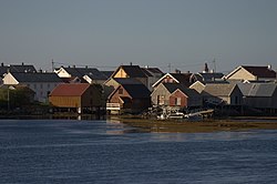
 View of Veiholmen | |
 Smøla within Møre og Romsdal | |
| Coordinates: 63°24′07″N 08°01′45″E / 63.40194°N 8.02917°E | |
| Country | Norway |
| County | Møre og Romsdal |
| District | Nordmøre |
| Established | 1 Jan 1960 |
| Administrative centre | Hopen |
| Government | |
| • Mayor (2019) | Svein Roksvåg (Sp) |
| Area | |
| • Total | 271.91 km2 (104.99 sq mi) |
| • Land | 261.09 km2 (100.81 sq mi) |
| • Water | 10.82 km2 (4.18 sq mi) 4% |
| • Rank | 272 in Norway |
| Population (2020) | |
| • Total | 2,150 |
| • Rank | 272 in Norway |
| • Density | 8.2/km2 (21/sq mi) |
| • Change (10 years) | 0.3% |
| Demonym | Smølværing[1] |
| Time zone | UTC+01:00 (CET) |
| • Summer (DST) | UTC+02:00 (CEST) |
| ISO 3166 code | NO-1573 |
| Official language form | Neutral[2] |
| Website | smola |
Smøla is a municipality in Møre og Romsdal county, Norway. It is part of the Nordmøre region.
Smøla is the 272nd most populous municipality in Norway with a population of 2,150.[3][4]
Related pages[change | change source]
References[change | change source]
- ↑ "Navn på steder og personer: Innbyggjarnamn" (in Norwegian). Språkrådet.
- ↑ "Forskrift om målvedtak i kommunar og fylkeskommunar" (in Norwegian). Lovdata.no.
- ↑ Statistisk sentralbyrå (2020). "Table: 06913: Population 1 January and population changes during the calendar year (M)" (in Norwegian).
- ↑ Statistisk sentralbyrå (2020). "09280: Area of land and fresh water (km²) (M)" (in Norwegian).


