
Stockbridge, Michigan
Stockbridge, Michigan | |
|---|---|
 | |
 Location within Ingham County | |
 Stockbridge Location within the state of Michigan  Stockbridge Location within the United States | |
| Coordinates: 42°26′54″N 84°10′32″W / 42.44833°N 84.17556°W | |
| Country | United States |
| State | Michigan |
| County | Ingham |
| Township | Stockbridge |
| Settled | 1835 |
| Government | |
| • Type | Village council |
| Area | |
| • Total | 1.52 sq mi (3.94 km2) |
| • Land | 1.50 sq mi (3.89 km2) |
| • Water | 0.02 sq mi (0.04 km2) |
| Elevation | 932 ft (284 m) |
| Population | |
| • Total | 1,244 |
| • Density | 827.68/sq mi (319.49/km2) |
| Time zone | UTC-5 (Eastern (EST)) |
| • Summer (DST) | UTC-4 (EDT) |
| ZIP code(s) | 49285 |
| Area code | 517 |
| FIPS code | 26-76560[4] |
| GNIS feature ID | 2399902[2] |
| Website | Official website |
Stockbridge is a village in Ingham County in the U.S. state of Michigan. It is about 36 miles (58 km) southeast from downtown Lansing. 1,244 people lived here at the 2020 census.[3]
References[change | change source]
- ↑ "2020 U.S. Gazetteer Files". United States Census Bureau. Retrieved May 21, 2022.
- ↑ 2.0 2.1 U.S. Geological Survey Geographic Names Information System: Stockbridge, Michigan
- ↑ 3.0 3.1 "Profile of General Population and Housing Characteristics: 2020 Demographic Profile Data (DP-1): Stockbridge village, Michigan". United States Census Bureau. Retrieved February 20, 2024.
- ↑ "U.S. Census website". United States Census Bureau. Retrieved 2008-01-31.
Municipalities and communities of Ingham County, Michigan, United States | ||
|---|---|---|
| Cities | 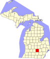 | |
| Villages | ||
| Charter townships | ||
| Civil townships | ||
| CDPs | ||
| Other unincorporated communities | ||
| Footnotes | ‡This populated place also has portions in an adjacent county or counties | |