Texico, New Mexico
Texico, New Mexico | |
|---|---|
 Grain elevator in New Mexico, wooden building in Texas | |
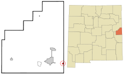
 Location of Texico, New Mexico | |
| Coordinates: 34°23′28″N 103°2′54″W / 34.39111°N 103.04833°W | |
| Country | United States |
| State | New Mexico |
| County | Curry |
| Area | |
| • Total | 0.83 sq mi (2.14 km2) |
| • Land | 0.83 sq mi (2.14 km2) |
| • Water | 0.00 sq mi (0.00 km2) |
| Elevation | 4,147 ft (1,264 m) |
| Population (2020) | |
| • Total | 956 |
| • Density | 1,155.99/sq mi (446.31/km2) |
| Time zone | UTC-7 (Mountain (MST)) |
| • Summer (DST) | UTC-6 (MDT) |
| ZIP code | 88135 |
| Area code | 575 |
| FIPS code | 35-77250 |
| GNIS feature ID | 0915905 |
Texico is a city in Curry County, New Mexico, United States. 956 people lived here at the 2020 census. The city is on the Texas-New Mexico border with the town of Farwell across the border.
References[change | change source]
- ↑ "ArcGIS REST Services Directory". United States Census Bureau. Retrieved September 20, 2022.

