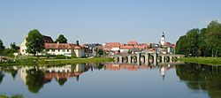
Tirschenreuth
Tirschenreuth | |
|---|---|
 Panorama of the Old Town of Tirschenreuth | |
| Coordinates: 49°53′N 12°20′E / 49.883°N 12.333°E | |
| Country | Germany |
| State | Bavaria |
| Admin. region | Upper Palatinate |
| District | Tirschenreuth |
| Government | |
| • Mayor (2020–26) | Franz Stahl[1] (CSU) |
| Area | |
| • Total | 66.54 km2 (25.69 sq mi) |
| Elevation | 504 m (1,654 ft) |
| Population (2022-12-31)[2] | |
| • Total | 8,655 |
| • Density | 130/km2 (340/sq mi) |
| Time zone | UTC+01:00 (CET) |
| • Summer (DST) | UTC+02:00 (CEST) |
| Postal codes | 95643 |
| Dialling codes | 09631 |
| Vehicle registration | TIR, KEM |
| Website | www.stadt-tirschenreuth.de |
Tirschenreuth (Northern Bavarian: Dirschnrad, Diascharad) is the capital city of the district of Tirschenreuth. It is in the northeast of Bavaria, close to the Czech-Bavarian border.
Geography[change | change source]
Tirschenreuth is in the north of Upper Palatinate administrative region, about 75 miles north of Regensburg and 35 miles east of Bayreuth.
Incorporations[change | change source]
The following villages were incorporated in Tirschenreuth
- Großklenau
- Kleinklenau
- Brunn
- Gründlbach
- Haid
- Höfen
- Hohenwald
- Kleinkonreuth
- Lengenfeld
- Lohnsitz
- Marchaney
- Matzersreuth
- Mooslohe
- Pilmersreuth a. d. Straße
- Pilmersreuth a. Wald
- Rosall
- Rothenbürg
- Sägmühle
- Wondreb
- Wondrebhammer
- Zeidlweid
- Ziegelhütte
Twin towns and cities[change | change source]

Tirschenreuth is twinned with:
 La Ville-du-Bois, France (2001)
 Planá, Czech Republic (2008)
 Lauf an der Pegnitz, Germany (2011)
 Santa Fe Springs, California, United States
References[change | change source]
- ↑ Liste der ersten Bürgermeister/Oberbürgermeister in kreisangehörigen Gemeinden, Bayerisches Landesamt für Statistik, 15 July 2021.
- ↑ Genesis Online-Datenbank des Bayerischen Landesamtes für Statistik Tabelle 12411-003r Fortschreibung des Bevölkerungsstandes: Gemeinden, Stichtag (Einwohnerzahlen auf Grundlage des Zensus 2011)


