Tomioka, Fukushima
Tomioka
富岡町 | |
|---|---|
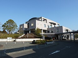
 Tomioka Town Hall | |
 Location of Tomioka in Fukushima Prefecture | |
| Coordinates: 37°19′59″N 141°01′01″E / 37.33306°N 141.01694°E | |
| Country | Japan |
| Region | Tōhoku |
| Prefecture | Fukushima |
| District | Futaba |
| Government | |
| • -Mayor | Katsuya Endou |
| Area | |
| • Total | 68.47 km2 (26.44 sq mi) |
| Population (October 2016) | |
| • Total | 0 |
| • Density | 0/km2 (0/sq mi) |
| Time zone | UTC+9 (Japan Standard Time) |
| - Tree | Sakura |
| - Flower | Azalea |
| - Bird | Motacillidae |
| Phone number | 0120-33-6466 |
| Address | Motooka Otsuka 622-1, Tomioka-machi, Futaba-gun, Fukushima-ken 979-1192 |
| Website | Official website |
Tomioka (富岡町, Tomioka-machi) is a Japanese town in Fukushima Prefecture on the island of Honshu.
History[change | change source]
Tomioka is close to Fukushima Daiichi Nuclear Power Plant. The town is inside the 20 km exclusion zone which was created after the Fukushima nuclear disaster in 2011.[1] Animals still live in the Tomioka "no-go zone".[2]
The Fukushima Daini Nuclear Power Plant is partly in Tomioka. The town government has moved temporarily to Kōriyama since 17 March 2011.
Gallery[change | change source]
-
Fukushima disaster evacuation zones
Related pages[change | change source]
References[change | change source]
- ↑ Harada, Koji. "Nuclear zone holdouts, old dog ‘Miracle’ live on," The Japan Times. November 28, 2012. Retrieved 2013-3-12.
- ↑ "Animals in Fukushima no-go zone," Kyodo News. 13 March 2013. Retrieved 2013-3-13.
Wikimedia Commons has media related to Tomioka, Fukushima.


