
Trachselwald
Trachselwald | |
|---|---|
 Coat of arms | |
Location of Trachselwald  | |
 Trachselwald  Trachselwald | |
| Coordinates: 47°1′N 7°43′E / 47.017°N 7.717°E | |
| Country | Switzerland |
| Canton | Bern |
| District | Emmental |
| Government | |
| • Mayor | Gemeindepräsident Christian Kopp (as of January 2009) |
| Area | |
| • Total | 15.98 km2 (6.17 sq mi) |
| Elevation | 685 m (2,247 ft) |
| Highest elevation | 1,200 m (3,900 ft) |
| Lowest elevation | 660 m (2,170 ft) |
| Population (31 December 2018)[2] | |
| • Total | 960 |
| • Density | 60/km2 (160/sq mi) |
| Time zone | UTC+01:00 (Central European Time) |
| • Summer (DST) | UTC+02:00 (Central European Summer Time) |
| Postal code(s) | 3456 |
| SFOS number | 0958 |
| Surrounded by | Langnau im Emmental, Lauperswil, Lützelflüh, Rüderswil, Sumiswald |
| Website | www SFSO statistics |
Trachselwald is a municipality in the administrative district of Emmental in the Swiss canton of Bern.
Gallery[change | change source]
-
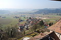 Trachselwald
 -
 Trachselwald Castle
 -
 Church of Trachselwald
_072.JPG)

_028.JPG)
References[change | change source]
- ↑ 1.0 1.1 "Arealstatistik Standard - Gemeinden nach 4 Hauptbereichen". Federal Statistical Office. Retrieved 13 January 2019.
- ↑ "Ständige Wohnbevölkerung nach Staatsangehörigkeitskategorie Geschlecht und Gemeinde; Provisorische Jahresergebnisse; 2018". Federal Statistical Office. 9 April 2019. Retrieved 11 April 2019.
Other websites[change | change source]
![]() Media related to Trachselwald at Wikimedia Commons
Media related to Trachselwald at Wikimedia Commons
- Official website of Trachselwald (in German)