
Traunstein (mountain)
| Traunstein | |
|---|---|
 Traunstein from Traunkirchen | |
| Highest point | |
| Elevation | 1,691 m (5,548 ft) |
| Prominence | 694 m (2,277 ft)[1] |
| Isolation | 11.8 km (7.3 mi) |
| Coordinates | 47°52′25″N 13°50′26″E / 47.87361°N 13.84056°E |
| Geography | |
 Traunstein Location in Austria | |
| Location | Upper Austria, Austria |
| Parent range | Upper Austrian Prealps |
Traunstein is the highest mountain on the east side of Lake Traunsee. It is in the district of Gmunden, Austria. The Traunstein is 1691 metres (5548 ft) high. The height is the reason why it can be seen from very far away.[2]
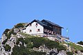
On the top are two cabins, the Naturfreundehütte and the Gmundnerhütte.
-
 Traunsteinhütte (Naturfreundehütte)
 -
 Gmundnerhütte


References[change | change source]
- ↑ "Traunstein -peakbagger". peakbagger.com. Retrieved 16 March 2015.
- ↑ "Bergtour zum Traunstein". www.ausflugstipps.at.