
Trettachspitze
| Trettachspitze | |
|---|---|
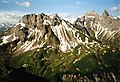
 The Trettachspitze from the north | |
| Highest point | |
| Elevation | 2595m |
| Prominence | 145 m ↓ Trettachscharte → Mädelegabel |
| Isolation | 0.4 km → Mädelegabel |
| Coordinates | 47°18′00″N 10°17′00″E / 47.3°N 10.283333°E |
| Geography | |
| Parent range | Central ridge, Allgäu Alps |
| Geology | |
| Mountain type | Dolomite |
| Climbing | |
| First ascent | 1855 by Urban, Alois and Mathias Jochum |

The Trettachspitze is a mountain in the Allgäu Alps in Germany. It is made of Dolomite and is 2,595 metres (8,514 ft) high.[1] It is one of the best-known mountains in the Allgäu Alps.
It is the only high rocky mountain in the Allgäu Alps that is completely in Germany. With the Mädelegabel (2,645 metres, 8,678 feet) and the Hochfrottspitze (2,649 metres, 8,691 feet) it forms the famous threesome of mountains on the main ridge of the Allgäu Alps. It is found north of the Mädelegabel. It was first climbed in 1855 by 3 brothers, Urban, Alois and Mathias Jochum.
Gallery[change | change source]
-
 West face of the Trettachspitze
 -
 The Trettachspitze from the Hierenalpe
 -
 The Mädelegabel Group from the Guggersee
 -
 The Kratzer, Mädelegabel and Trettachspitze


Additional reading[change | change source]
- Ernst Enzenperger: Die Gruppe der Mädelegabel, München, Jos. Köselsche Buchhandlung, 1909
- Meineke, Stefan (1998). Allgäu-Kletterführer (in German). ISBN 3931982084.
- Thaddäus, Steiner (2007). Allgäuer Bergnamen (in German) (3rd ed.). Fink Kunstverlag Josef. ISBN 9783898703895.
- Thaddäus Steiner: Die Flurnamen der Gemeinde Oberstdorf im Allgäu, München, Selbstverlag des Verbandes für Flurnamenforschung in Bayern, 1972
- Thaddäus Steiner: Hieß die Trettachspitze einst Giis(t)kopf in Unser Oberstdorf, Blätter zur Oberstdorfer Heimatgeschichte. Heft 9/1986, S. 68.
- Seibert, Dieter (2004). Allgäuer Alpen und Ammergauer Alpen alpin (in German). ISBN 3763311262.
- Alpenvereinskarte 1:25.000, Blatt 2/1, Allgäuer- Lechtaler Alpen, West