Tuguegarao
Tuguegarao, officially called the City of Tuguegarao, is a city in the Cagayan Province of Northeastern Philippines. Tuguegarao is the capital and largest city of the Cagayan Province in the Philippines. The city has a population of 170,000 people, making it the most populous city in the Cagayan Province of Northeastern Philippines. The highest temperature recorded in the Philippines was in Tuguegarao, where it hit 42 degrees Celsius back in May 11,1969. The city is surrounded by the Sierra Madre Mountain Range to the right.
Tuguegarao
Lungsod ng Tuguegarao | |
|---|---|
City | |
| City of Tuguegarao | |
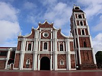
From top, clockwise: Central Business District along Bonifacio Street; Bagumbayan horno (kiln) ruins; St. Peter Metropolitan Cathedral; Buntun Bridge, the country's longest river bridge; Ermita de Piedra de San Jacinto (Stone Chapel of St. Hyacinth) | |
| Nickname: Premier Ibanag City | |
| Founded | May 9, 1604 |
| Cityhood | December 18, 1999 |
History[change | change source]
Tuguegarao was founded in May 9, 1604, and it's cityhood was founded in December 18, 1999. In 1720, Father Antonio Lobato, O.P developed a street network together with the construction of Tuguegarao Cathedral. In 1839, Tuguegarao was transfered from Lal-o as the Manila-Tuguegarao road was opened, which had socio-economic progress. American troops occupied the town in December 12, 1899. Some changes in the city were noticed over the course of provincial administrations. The first provincial capitol was built in 1909. The Cagayan Valley College of Arts and Trades was founded by an American named Claude Andrews. During World War II, the city and its airfield was captured by the Japanese Imperial Army on December 12, 1941, as part of the Japanese invasion of Appari. The city soon became the capital and seat of the regional government of Cagayan Valley back in 1975.
Geography[change | change source]
Tuguegarao's location is in the bottom part of the province. The city is bordered by Iguig at the top; Cagayan River and Solana to the left; and to the right by Peñablanca. The city is almost enclosed by the Cagayan River in the leftwards and downwards part of the city. Small bodies of waters are found in the city. Historically, the residents of this town mainly relied on fishing, farming, and hunting. Additionally, natives have ventured on weaving cloth. The city comprises of forty-nine barangays.
Religion[change | change source]
The dominant religion of Tuguegarao and all the rest of the Philippines is Catholic Christianity, due to the invasion of Spanish people in 1521. The remaining religions are divided with Islam and other Christian groups.
Climate[change | change source]
Tuguegarao experiences a hot climate. The average temperature during March and April is 38 degrees Celsius, one of the highest in the country. On May 11, 1969, the highest temperature in the Philippines was recorded in Tuguegarao at 42 degrees Celsius, beating the previous record of 39 degrees Celsius which was also measured in Tuguegarao in May 1912. The city was tagged as the "Hottest City in the Philippines".
Culture[change | change source]
Every August, an annual festival takes place in Tuguegarao, celebrated in commemoration of the city's patron saint, San Jacinto de Polonia, whose feast day falls on August 16. The main event of the celebration is its opening day. The concept started back in 2014. Other highlights of the weeklong festival include contests, where various schools participate, everyone dressed in colorful costumes and props.
Transportation[change | change source]
Transportation plays a main part in keeping Tuguegarao's economy up and running.
Gallery[change | change source]
Tuguegarao buildings.
Church of San Jacinto in Tuguegarao.
The ruins of Horno in Tuguegarao.
Buntun bridge at nautical twilight.
Tuguegarao Cathedral, the most popular church in Tuguegarao.


