
Ueberstrass
Ueberstrass
Íwerstrooss | |
|---|---|
 The town hall in Ueberstrass | |
.svg) Coat of arms | |
Location of Ueberstrass  | |
 Ueberstrass  Ueberstrass | |
| Coordinates: 47°33′11″N 7°09′32″E / 47.5531°N 7.1589°E | |
| Country | France |
| Region | Grand Est |
| Department | Haut-Rhin |
| Arrondissement | Altkirch |
| Canton | Masevaux |
| Intercommunality | Canton of Hirsingue |
| Government | |
| • Mayor (2001–2008) | Bernard Ley |
| Area 1 | 5.12 km2 (1.98 sq mi) |
| Population (2006) | 350 |
| • Density | 68/km2 (180/sq mi) |
| Time zone | UTC+01:00 (CET) |
| • Summer (DST) | UTC+02:00 (CEST) |
| INSEE/Postal code | 68340 /68580 |
| Elevation | 354–427 m (1,161–1,401 ft) (avg. 370 m or 1,210 ft) |
| 1 French Land Register data, which excludes lakes, ponds, glaciers > 1 km2 (0.386 sq mi or 247 acres) and river estuaries. | |
Ueberstrass (Alemannic German: Íwerstrooss; German: Überstrass) is a commune. It is in the Haut-Rhin department of east France.
Sights[change | change source]
- The church of Sainte-Thérèse-de-l'enfant-Jésus
- The chapel of Our Lady of Grunenwald
- The chapel of Saint-Jean, dating from the fifteenth century
-
 Sainte-Thérèse-de-l'enfant-Jésus Church
 -
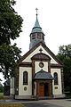 The chapel of Our Lady of Grunenwald


Related pages[change | change source]
References[change | change source]
Other websites[change | change source]
![]() Media related to Ueberstrass at Wikimedia Commons
Media related to Ueberstrass at Wikimedia Commons