Uniontown, Pennsylvania
Uniontown, Pennsylvania | |
|---|---|
From left to right, from top: Downtown, State Theatre Center for the Arts, Adam Clarke Nutt Mansion, Gallatin School, and Hopwood House. | |
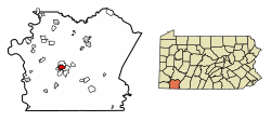
 Location of Uniontown in Fayette County, Pennsylvania. | |
| Coordinates: 39°54′0″N 79°43′28″W / 39.90000°N 79.72444°W | |
| Country | United States |
| State | Pennsylvania |
| County | Fayette |
| Established | July 4, 1776 |
| Area | |
| • Total | 2.05 sq mi (5.32 km2) |
| • Land | 2.05 sq mi (5.32 km2) |
| • Water | 0.00 sq mi (0.00 km2) |
| Elevation | 999 ft (304 m) |
| Population | |
| • Total | 9,984 |
| • Density | 4,731.74/sq mi (1,827.24/km2) |
| Time zone | UTC−5 (EST) |
| • Summer (DST) | UTC−4 (EDT) |
| ZIP Code | 15401 |
| Area code(s) | 724, 878 |
| FIPS code | 42-78528 |
Uniontown is a city in Fayette County, Pennsylvania, United States, 46 miles (74 km) southeast of Pittsburgh. The population was 9,984 at the 2020 census.[2] It is the county seat and largest city of Fayette County.[3]
References[change | change source]
- ↑ "2019 U.S. Gazetteer Files". United States Census Bureau. Retrieved July 28, 2020.
- ↑ 2.0 2.1 "QuickFacts: Uniontown city, Pennsylvania". United States Census Bureau. Retrieved September 11, 2023.
- ↑ "Find a County". National Association of Counties. Archived from the original on May 31, 2011. Retrieved June 7, 2011.


