
User:KevRobbSIMPLE/sandbox
| Barraba New South Wales | |||||||||
|---|---|---|---|---|---|---|---|---|---|
 Queen Street, Bararba | |||||||||
 Barraba | |||||||||
| Coordinates | 30°22′42″S 150°36′38″E / 30.37833°S 150.61056°E | ||||||||
| Population | 1410[1] (2016) | ||||||||
| Established | 1850's | ||||||||
| Time zone | AEST (UTC+10) | ||||||||
| • Summer (DST) | AEDT (UTC+11) | ||||||||
| Location | |||||||||
| LGA(s) | Tamworth Regional Council | ||||||||
| County | Darling | ||||||||
| State electorate(s) | Tamworth | ||||||||
| Federal division(s) | New England | ||||||||
| |||||||||
Barraba is a village in New South Wales, Australia. This village is in the New England region and it is in the local government area of Tamworth Regional Council. This village is also in the Bundarra-Barraba Important Bird Area. This area is for the conservation of an endangered bird, the Regent Honeyeater (Anthochaera phrygia).
Barraba is 477 kilometres (296 miles) north-west from Sydney and 548 kilometres (341 miles) south-west from Brisbane. Barraba is 90 kilometres (56 miles) north from Tamworth, which is the nearest city. The Manilla River flows next to Barraba. This village is on a road called Fossickers Way and it is in a mountain range called the Nandewar Range.

History[change | change source]
Indigenous Australians called the Kamileroi lived in the district before the European people arrived.[2] The first European in the district was an explorer and botanist named Allan Cunningham, who came there in 1827.[3] The first farm in the district, Barraba Station, began in 1837 or 1838.[2][4] The site of the village was surveyed in 1852.[5]
The discovery of gold helped the village to grow bigger.[5] The first post office was opened in 1856[6] and the first school was opened in 1861.[2] The first Anglican church was built in 1876[4] and the first bank was also opened in 1876.[4] The first hotel, The Commerical Hotel, was built in 1878[4] and the first court house was built in 1881.[4] Barraba was officially called a village in 1885.[4][5] The hospital was built in 1891[4] and the Methodist church was built in 1898.[4]
Barraba's newspaper, The Barraba Gazette, began publishing in 1901.[4] The Catholic church was built in 1906.[4] The railway came to Barraba in 1908,[7] however the last train went to Barraba in 1983 and the line closed in 1987.[8] The Connors Creek Dam was built in 1933.[4] This dam improved the water supply of the village.

Mining[change | change source]
Copper[change | change source]
Copper was disovered at Gulf Creek in 1889 and the first mine was started in 1892.[2] Gulf Creek is 22 kilometres (14 miles) north-east from Barraba. A small village began to grow, which had a hotel, a school, and a post office.[9] This copper mine was the biggest copper mine in New South Wales in 1903 and the little village had 300 people living there. The mine was closed in the 1930's, and the post office was closed in 1966.[6] The little village was abandoned.

Asbestos[change | change source]
Asbestos was mined from 1919 until 1983 at Woodsreef, which was a little village 15 kilometres (10 miles) east from Barraba. The mine was made bigger in 1974. This mine produced 5,000,000 metric tonnes of white asbestos.
The abandoned mine left behind 75,000,000 metric tonnes of waste rocks and 25,000,000 metric tonnes of asbestos. The asbestos heap covers 43 hectares (107 acres) and is up to 70 metres (230 feet) high.[10]
A television report in 2008 described the growing worry that the remaining asbestos could harm the health for the people who live in Barraba and for the people who visit the village.[11] A foundation, The Asbestos Diseases Foundation of Australia, demanded that the mine should be cleaned up. This foundation also demanded that people must not be allowed to go to the mine. A public dirt road crossed the mine site but that road was closed in 2013. The little village was abandoned.
The government health service, Hunter-New England Health, did an urgent study about the possible harm to the health of the people of Barraba, but that study has not been published.[12]
-
 the asbestos mine at Woodsreef
 -
 asbestos
 -
 cloth made from asbestos
 -
 asbestosis, a disease caused by asbestos


Diatomite[change | change source]
Diatomite, or diatomaceous earth, is a mineral made from the fossils of diatoms. This mineral is used to make explosives, filters, abrasives, insecticide, thermal materials, catalysis support, in farming, and in construction. A mine was started near Barraba in 1982.
_Monterey_Formation_at_a_diatomite_quarry_just_south_of_Lompoc.jpg)
Jewels and Fossils[change | change source]
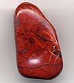
Pyrites, jasper, garnets, zeolite, and red, yellow, and brown quartz can be found around Barraba. Searching for these jewels is called fossicking. People can also find fossils around Barraba.
-
 pyrite
 -
 red jasper
 -
 garnet
 -
 zeolite


Farming[change | change source]
The farms in the district have cattle for beef, merino sheep for wool and mutton, and they can also grow wheat.
-
 cattle for beef
 -
 Merino sheep
 -
 wheat
wheat


Climate[change | change source]
The summers in Barraba are hot and humid, and the winters here are cold and dry. The highest recorded temperature is 41.8° Celsius (107° Fahrenheit) and the lowest recorded temperature is -9.4° Celsius (15° Fahrenheit). The average yearly rainfall is 688.7 millimetres (27 inches) and the most rain that fell in one day is 194.3 millimetres (7.5 inches) which fell on 25 February 1955.[13]
Water[change | change source]
Before Split Rock Dam was built, the people in Barraba got their water from the Manilla River, Barraba Creek, and Connors Creek Dam. When these sources were almost empty, the people got there water from emergency wells.[14][15]
The Split Rock Dam was built in 1988 and a pipeline from that dam to Barraba was built in 2015.
.JPG)
Photographs[change | change source]
-
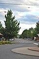 Queen Street is the main street of Barraba
 -
 the court house, Barraba
 -
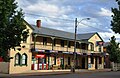 the Commercial Hotel, Barraba
 -
 the Anglican church, Barraba
 -
 the Methodist (now Uniting) church, Barraba
 -
 the Catholic church, Barraba
 -
 the clock tower, Barraba
 -
 the first bank, Barraba


Links[change | change source]
- Barraba's webpage
- Barraba's webpage on Facebook
- the "Frost over Barraba" arts festival
- Barraba's festival
- from the website of the Tamworth Regional Council
- from the website of the Fossickers Way
- video: Connors Creek Dam
- video: the asbestos mine at Woodsreef
- video: Split Rock Dam
References[change | change source]
- ↑ "2016 Census QuickStats – Barraba (State Suburb)". Australian Bureau of Statistics. July 6, 2018. Retrieved August 18, 2018.
- ↑ 2.0 2.1 2.2 2.3 "Barraba". Sydney Morning Herald Traveller. November 13, 2008. Retrieved November 14, 2011.
- ↑ "Barraba". Visit Tamworth. Tamworth Regional Council. Retrieved November 14, 2011.
- ↑ 4.00 4.01 4.02 4.03 4.04 4.05 4.06 4.07 4.08 4.09 4.10 "Barraba Dateline". Barraba NSW – The Community Website. Archived from the original on March 17, 2012. Retrieved November 14, 2011.
- ↑ 5.0 5.1 5.2 Boileau, Joanna (February 2007). "Thematic History of Nundle, Manilla and Barraba". Tamworth Regional Council. pp. 124–125. Retrieved November 14, 2011.
- ↑ 6.0 6.1 "Post Office History". Post Office List – NSW. Premier Postal Auctions. Retrieved November 14, 2011.
- ↑ "THE BARRABA RAILWAY". The Sydney Morning Herald. National Library of Australia. September 22, 1908. p. 7. Retrieved November 15, 2011.
- ↑ Bozier, Rolfe. "Barraba Branch". NSWrail.net. Retrieved November 15, 2011.
- ↑ "MINING IN NEW SOUTH WALES". The Sydney Morning Herald. National Library of Australia. July 29, 1901. p. 8. Retrieved November 15, 2011.
- ↑ Woodsreef Asbestos Mine Site Rehabilitation Private Members Statement, 29 August 2008. Archived April 3, 2011, at the Wayback Machine
- ↑ Abandoned asbestos mine causes community outrage
- ↑ Woodsreef health report under wraps Archived July 6, 2011, at the Wayback Machine
- ↑ "Climate Statistics for Barraba Post Office". Climate statistics for Australian locations. Bureau of Meteorology. Retrieved November 16, 2011.
- ↑ Barraba Water Supply Archived 2011-06-28 at the Wayback Machine
- ↑ Barraba's water supply critical