
Vauxhall station
| Vauxhall | |
|---|---|
 | |
 Vauxhall Location of Vauxhall in Greater London | |
| Location | Vauxhall |
| Local authority | London Borough of Lambeth |
| Managed by | South Western Railway |
| Station code | VXH |
| DfT category | B |
| Number of platforms | 10 |
| Accessible | Yes[1] |
| Fare zone | 1 and 2 |
| London Underground annual entry and exit | |
| 2017 | |
| 2018 | |
| 2019 | |
| 2020 | |
| 2021 | |
| National Rail annual entry and exit | |
| 2013–14 | |
| 2014–15 | |
| 2015–16 | |
| 2016–17 | |
| Key dates | |
| 11 July 1848 | Opened (LSWR) |
| 23 July 1971 | Opened (London Underground) |
| Other information | |
| External links | |
| WGS84 | 51°29′07″N 0°07′22″W / 51.4854°N 0.1229°W |
Vauxhall station is an important railway station in the London district of Vauxhall. It is a National Rail, London Underground and London Buses interchange station. Its position is at the Vauxhall Cross road junction, opposite the southern approach to Vauxhall Bridge. The station is on the boundary of zones 1 and 2 of the London Travelcard area.
The bus station is at ground level across the road from the rail station. It is the second busiest London bus station, after that at Victoria. It has a photovoltaic roof supplying much of its electricity.
Services[change | change source]
Vauxhall underground is served by the Victoria Line and is between Pimlico and Stockwell.
Vauxhall rail station is served by South West Trains services to and from London Waterloo. The typical off-peak service is:
- 29tph to London Waterloo
- 4tph to Chessington
- 4tph to Dorking
- 1every two hours to Guildford via Cobham
- 8tph to Guildford via Epsom
- 2tph to Hampton Court
- 2tph round the Hounslow loop via Hounslow and Richmond, returning to Waterloo
- 2tph round the Hounslow loop via Richmond and Hounslow, returning to Waterloo
- 2tph round the Kingston loop via Kingston and Richmond, returning to Waterloo
- 2tph round the Kingston loop via Richmond and Kingston, returning to Waterloo
- 2tph to Shepperton
- 2tph to Windsor & Eton Riverside
- 2tph to Woking
London buses routes 2, 36 (24 hour service), 77, 87, 88 (24 hour service), 156, 185, 196, 344 (24 hour service), 360, 436 and Night Bus routes N2, N87, N136 serve the station.
-
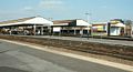 Vauxhall railway station platforms from the western end
 -
 A 1914 Railway Clearing House map of lines around Vauxhall station


References[change | change source]
- ↑ Standard Tube Map (PDF) (Map). Not to scale. Transport for London. May 2019. Archived (PDF) from the original on 1 June 2019.
- ↑ "Multi-year station entry-and-exit figures (2007–2017)". London Underground station passenger usage data. Transport for London. January 2018. Archived from the original (XLSX) on 31 July 2018. Retrieved 22 July 2018.
- ↑ "Station Usage Data" (CSV). Usage Statistics for London Stations, 2018. Transport for London. 21 August 2019. Archived from the original on 22 May 2020. Retrieved 27 April 2020.
- ↑ "Station Usage Data" (XLSX). Usage Statistics for London Stations, 2019. Transport for London. 23 September 2020. Archived from the original on 9 November 2020. Retrieved 9 November 2020.
- ↑ "Station Usage Data" (XLSX). Usage Statistics for London Stations, 2020. Transport for London. 16 April 2021. Retrieved 1 January 2022.
- ↑ "Station Usage Data" (XLSX). Usage Statistics for London Stations, 2021. Transport for London. 12 July 2022. Retrieved 7 September 2022.
- ↑ 7.0 7.1 7.2 7.3 "Station usage estimates". Rail statistics. Office of Rail Regulation. Please note: Some methodology may vary year on year.
Other websites[change | change source]
- Train times and station information for Vauxhall station from National Rail
- Plan of the mainline station Archived 2007-09-28 at the Wayback Machine
| Preceding station | Following station | |||
|---|---|---|---|---|
towards Brixton | Victoria line | towards Walthamstow Central |
||
| National Rail | ||||
| London Waterloo | South West Trains South Western Main Line |
Clapham Junction or Queenstown Road (Battersea) | ||