
Ville Platte, Louisiana
Ville Platte, Louisiana | |
|---|---|
| City of Ville Platte | |
| Etymology: Ville Platte, French ('Ville' being the French word for 'town' and 'platte' meaning 'flat') | |
 Interactive map of Ville Platte | |
| Coordinates: 30°41′21″N 92°16′39″W / 30.68917°N 92.27750°W | |
| Country | |
| State | |
| Parish | Evangeline |
| Founded | 1824 |
| Incorporated as a town | 1858 |
| Qualified to be incorporated as a city | 1950 |
| Founded by | Marcellin Garand |
| Government | |
| • Type | Mayor-council |
| • Mayor | Ryan Leday Williams |
| Area | |
| • Total | 4.02 sq mi (10.40 km2) |
| • Land | 4.02 sq mi (10.40 km2) |
| • Water | 0.00 sq mi (0.00 km2) |
| Elevation | 72 ft (22 m) |
| Population | |
| • Total | 6,303 |
| • Density | 1,569.08/sq mi (605.85/km2) |
| Time zone | UTC-6 (CST) |
| • Summer (DST) | UTC-5 (CDT) |
| ZIP code | 70586 |
| Area code | 337 |
| FIPS code | 22-78715 |
| Website | City of Ville Platte |
Ville Platte is the parish seat of Evangeline Parish, Louisiana, United States.
References[change | change source]
- ↑ "2020 U.S. Gazetteer Files". United States Census Bureau. Retrieved March 20, 2022.
- ↑ "QuickFacts: Ville Platt city, Louisiana". United States Census Bureau. Retrieved March 2, 2024.
Municipalities and communities of Evangeline Parish, Louisiana, United States | ||
|---|---|---|
| City | 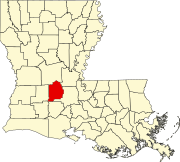 | |
| Towns | ||
| Villages | ||
| CDP | ||
| Other unincorporated communities | ||
| Footnotes | ‡This populated place also has portions in an adjacent parish or parishes | |