
Vézère
| Vézère | |
|---|---|
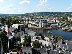
 Le Saillant, bridge over the river Vézère | |
 | |
| Location | |
| Country | France |
| Physical characteristics | |
| Source | |
| - location | Plateau de Millevaches |
| - elevation | 970 m (3,180 ft) |
| Mouth | |
| - location | Dordogne |
| - coordinates | 44°52′53″N 0°53′26″E / 44.88139°N 0.89056°E |
| Length | 211 km (131 mi) |
| Basin size | 3,708 km2 (1,432 sq mi) |
| Discharge | |
| - average | 50 m3/s (1,800 cu ft/s) |
| Basin features | |
| Progression | Dordogne→ Gironde estuary→ Atlantic Ocean |
The Vézère (Occitan: Vesera) is a river of southwestern France that flows through the Corrèze and Dordogne, in the Nouvelle-Aquitaine region. It is a right tributary of the Dordogne river.
The valley of the Vézère river is known for its prehistoric cave systems, with numerous cave paintings. UNESCO collectively designated these as a World Heritage Site in 1979.
Geography[change | change source]
The Vézère has a length of 211.2 km (131.2 mi), and a drainage basin with an area of approximately 9,656 km2 (3,728 sq mi).[1]
Its average yearly discharge (volume of water which passes through a section of the river per unit of time) is 57.7 m3/s (2,040 cu ft/s) at Campagne in the Dordogne department.[2]

Average monthly discharge (m3/s) at Campagne (1968-2017)[2]
Course[change | change source]
The Vézère starts in the Plateau de Millevaches, part of the Massif Central, in the commune of Meymac, Corrèze department, at an elevation of about 900 m (2,953 ft).[3]
It flows generally southwest through the Corrèze and Dordogne departments before flowing into the Dordogne river in Limeuil at about 5 m (16 ft) of altitude.[4]
The Vézère flows through 1 region, 2 departments and 53 communes.[1] The main communes are:
- Nouvelle-Aquitaine region
Main tributaries[change | change source]
The main tributaries (more than 20 km long) of the Vézère river are:
- Left tributaries
- Right tributaries
Gallery[change | change source]
-
 The Vézère river in Terrasson-Lavilledieu
 -
 The Vézère river in Montignac.
 -
 Confluence of the Dordogne, in front, and the Vézère.
.JPG)
.JPG)

Related pages[change | change source]
References[change | change source]
- ↑ 1.0 1.1 "La Vézère (P---0100)" (in French). SANDRE - Portail national d'accès aux référentiels sur l'eau. Archived from the original on 3 March 2016. Retrieved 10 March 2017.
- ↑ 2.0 2.1 "La Vézère à Campagne" (in French). Banque Hydro. Archived from the original on 6 March 2017. Retrieved 10 March 2017.
- ↑ "Sources de la Vézère" (in French). Géoportail. Retrieved 10 March 2017.
- ↑ "Confluence de la Vézère" (in French). Géoportail. Retrieved 10 March 2017.
- ↑ "Rivière d'Ars (P3010530)" (in French). SANDRE - Portail national d'accès aux référentiels sur l'eau. Archived from the original on 3 March 2016. Retrieved 10 March 2017.
- ↑ "Le Brézou (P31-0430)" (in French). SANDRE - Portail national d'accès aux référentiels sur l'eau. Archived from the original on 3 March 2016. Retrieved 10 March 2017.
- ↑ "La Corrèze (P3--0250)" (in French). SANDRE - Portail national d'accès aux référentiels sur l'eau. Retrieved 10 March 2017.
- ↑ "La Soudaine (P30-0400)" (in French). SANDRE - Portail national d'accès aux référentiels sur l'eau. Archived from the original on 3 March 2016. Retrieved 10 March 2017.
- ↑ "Le Bradascou (P31-0400)" (in French). SANDRE - Portail national d'accès aux référentiels sur l'eau. Archived from the original on 3 March 2016. Retrieved 10 March 2017.
- ↑ "La Loyre (P32-0400)" (in French). SANDRE - Portail national d'accès aux référentiels sur l'eau. Archived from the original on 4 March 2016. Retrieved 10 March 2017.
Other websites[change | change source]
- Banque Hydro - Station P4271010 - La Vézère à Campagne Archived 2015-02-19 at the Wayback Machine (in French)
- World Heritage profile