
Watkins Glen, New York
Watkins Glen, New York | |
|---|---|
 Franklin Street in Watkins Glen | |
 Watkins Glen Location within the state of New York  Watkins Glen Watkins Glen (the United States) | |
| Coordinates: 42°22′52″N 76°52′16″W / 42.38111°N 76.87111°W | |
| Country | United States |
| State | New York |
| County | Schuyler |
| Area | |
| • Total | 2.2 sq mi (5.8 km2) |
| • Land | 1.9 sq mi (4.8 km2) |
| • Water | 0.4 sq mi (1.0 km2) |
| Elevation | 463 ft (141 m) |
| Population (2020) | |
| • Total | 1,863 |
| • Estimate (2022) | 1,809 |
| • Density | 850/sq mi (320/km2) |
| Time zone | UTC-5 (Eastern (EST)) |
| • Summer (DST) | UTC-4 (EDT) |
| ZIP code | 14891 |
| Area code | 607 |
| FIPS code | 36-78696[1] |
| GNIS feature ID | 0974082[2] |
Watkins Glen is a village in and the county seat of Schuyler County,[3] New York, United States.
References[change | change source]
- ↑ "American FactFinder". United States Census Bureau. Retrieved 2008-01-31.
- ↑ "US Board on Geographic Names". United States Geological Survey. 2007-10-25. Retrieved 2008-01-31.
- ↑ "Find a County". National Association of Counties. Retrieved 2011-06-07.
Municipalities and communities of Schuyler County, New York, United States | ||
|---|---|---|
| CDPs | 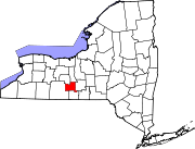 | |
| Towns | ||
| Villages | ||
| Hamlets | ||