
Yell County, Arkansas
Yell County | |
|---|---|
 Yell County Courthouse, Dardanelle | |
 Location within the U.S. state of Arkansas | |
 Arkansas's location within the U.S. | |
| Coordinates: 34°59′54″N 93°27′09″W / 34.9983°N 93.4525°W | |
| Country | |
| State | |
| Founded | December 5, 1840 |
| Named for | Archibald Yell |
| Seat | Danville (western district); Dardanelle (eastern district) |
| Largest city | Dardanelle |
| Area | |
| • Total | 949 sq mi (2,460 km2) |
| • Land | 930 sq mi (2,400 km2) |
| • Water | 19 sq mi (50 km2) 2.0% |
| Population | |
| • Total | 20,263 |
| • Density | 21/sq mi (8.2/km2) |
| Time zone | UTC−6 (Central) |
| • Summer (DST) | UTC−5 (CDT) |
| Website | yellcountyar |
Yell County is a county of the U.S. state of Arkansas. As of the 2020 census, the population was 20,263.[1] The county seats are Dardanelle and Danville.[2] It was founded on December 5, 1840.
References[change | change source]
- ↑ 1.0 1.1 "QuickFacts: Yell County, Arkansas". United States Census Bureau. Retrieved August 8, 2023.
- ↑ "Find a County". National Association of Counties. Retrieved 2011-06-07.
Municipalities and communities of Yell County, Arkansas, United States | ||
|---|---|---|
| Cities | 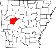 | |
| Town | ||
| CDPs | ||
| Other unincorporated communities | ||
| Footnotes | ‡This populated place also has portions in an adjacent county or counties | |
