
Yonne
Yonne | |
|---|---|
 Prefecture building of the Yonne department, in Auxerre. | |
 Flag  Coat of arms | |
 Yonne in France | |
| Coordinates: 47°48′N 3°34′E / 47.800°N 3.567°E | |
| Country | France |
| Region | Bourgogne-Franche-Comté |
| Département | 4 March 1790 |
| Prefecture | Auxerre |
| Subprefectures | Avallon, Sens |
| Government | |
| • President | André Villiers[1] |
| Area | |
| • Total | 7,427.4 km2 (2,867.7 sq mi) |
| Population (2014)[3] | |
| • Total | 341,814 |
| • Density | 46/km2 (120/sq mi) |
| Demonym | Icaunais |
| Time zone | UTC+1 (CET) |
| • Summer (DST) | UTC+2 (CEST) |
| ISO 3166 code | FR-89 |
| Arrondissements | 3 |
| Cantons | 21 |
| Communes | 428 |
| Website | www.cg89.fr |
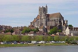
Yonne is a department in the centre of France, in the Bourgogne-Franche-Comté region. The largest city in the department, and its prefecture (capital), is Auxerre.
The department is named after the Yonne river, a tributary of the Seine, that flows through the department. The Celts name of the river was Ica-onna (Latin: Icauna) and from this name come the name of the river and of the people living in the department: Icaunais.[4]
History[change | change source]
During Roman times, the main city in the territory of the present department was Sens, the capital of one Roman province.[4]
Yonne is one of the original 83 departments created during the French Revolution on 4 March 1790 with Auxerre as its capital.[5] It was formed from combined parts of the old provinces of Burgundy, Champagne and Île-de-France.[4]
It was divided in seven districts: Auxerre, Sens, Joigny, Saint-Fargeau, Avallon, Tonnerre and Saint-Florentin.[5]
In 1800, with the creation of the arrondissements in France, the seven districts were changed into five arrondissements: Auxerre, Avallon, Joigny, Sens and Tonnerre. On 10 September 1926, the arrondissements of Joigny and Tonnerre were eliminated.[5]
Geography[change | change source]

Yonne is part of the Bourgogne-Franche-Comté region. It has an area of 7,427.4 km2 (2,868 sq mi).[2] The highest point of the department is Bois de la Pérouse (47°18′57″N 4°1′8″E / 47.31583°N 4.01889°E), 607 m (1,991 ft) high.[6]
The department borders with five departments in four regions:
- Bourgogne-Franche-Comté region
- Grand Est region
- Aube (northeast)
- Centre-Val de Loire region
- Loiret (west)
- Île-de-France region
- Seine-et-Marne (northwest)
Places next to Yonne | ||||||||||
|---|---|---|---|---|---|---|---|---|---|---|
| ||||||||||
The northern part of the department is formed by plains that are part of the great plain of Paris. The mountains of the Morvan and the hills of the Auxerrois (the region around the city of Auxerre) are in the southern half of the department.
The main river in the department is the Yonne, a tributary of the Seine river that flows through the department from south to north. Other rivers that flow through the department are the Armançon, Loing, Ouanne and Serein rivers.
Climate[change | change source]
The Köppen climate classification type for the climate at Auxerre is an "Oceanic climate" (also known as Maritime Temperate climate) and of the subtype "Cfb".[7]
The average temperature for the year in Auxerre is 11.5 °C (52.7 °F). The warmest month, on average, is July with an average temperature of 20.2 °C (68.4 °F). The coolest month, on average is January, with an average temperature of 3.6 °C (38.5 °F).
The average amount of precipitation for the year in Auxerre is 957.6 mm (37.70 in). The month with the most precipitation on average is December with 106.7 mm (4.20 in) of precipitation. The month with the least precipitation on average is April with an average of 63.5 mm (2.50 in).[7]
Administration[change | change source]
Yonne is managed by the Departmental Council of Yonne in Auxerre. The department is part of the Bourgogne-Franche-Comté region.
Administrative divisions[change | change source]
There are 3 arrondissements (districts), 21 cantons and 428 communes (municipalities) in Yonne.[8]
| INSEE code |
Arrondissement | Capital | Population[9] (2014) |
Area[10] (km²) |
Density (Inh./km²) |
Communes |
|---|---|---|---|---|---|---|
| 891 | Auxerre | Auxerre | 179,922 | 3,514.6 | 51.2 | 171 |
| 892 | Avallon | Avallon | 47,594 | 2,209.2 | 21.5 | 139 |
| 893 | Sens | Sens | 114,298 | 1,703.6 | 67.1 | 118 |
The following is a list of the 21 cantons of the Yonne department (with their INSEE codes), following the French canton reorganisation which came into effect in March 2015:[11]
- Auxerre-1 (8901)
- Auxerre-2 (8902)
- Auxerre-3 (8903)
- Auxerre-4 (8904)
- Avallon (8905)
- Brienon-sur-Armançon (8906)
- Chablis (8907)
- Charny (8908)
- Cœur de Puisaye (8909)
- Gâtinais en Bourgogne (8910)
- Joigny (8911)
- Joux-la-Ville (8912)
- Migennes (8913)
- Pont-sur-Yonne (8914)
- Saint-Florentin (8915)
- Sens-1 (8916)
- Sens-2 (8917)
- Thorigny-sur-Oreuse (8918)
- Tonnerrois (8919)
- Villeneuve-sur-Yonne (8920)
- Vincelles (8921)
Demographics[change | change source]
The inhabitants of Yonne are known, in French, as Icaunais (women: Icaunaises).[12]
Yonne had a population, in 2014, of 341,814,[3] for a population density of 46.0 inhabitants/km2. The arrondissement of Auxerre, with 179,922 inhabitants, is the arrondissement with more inhabitants.[9]
Evolution of the population in Yonne

The cities with more than 5,000 inhabitants in the department are:
| City | Population[9] (2014) |
Arrondissement |
|---|---|---|
| Auxerre | 34,843 | Auxerre |
| Sens | 25,507 | Sens |
| Joigny | 9,672 | Auxerre |
| Avallon | 7,025 | Avallon |
| Migennes | 7,019 | Auxerre |
| Villeneuve-sur-Yonne | 5,352 | Sens |
| Charny Orée de Puisaye | 5,145 | Auxerre |
Gallery[change | change source]
-
-
 Sens on the Yonne river
 -

-

.jpg)


Related pages[change | change source]
References[change | change source]
- ↑ "Les 42 élus" (in French). Conseil Départemental de l'Yonne. Retrieved 15 June 2017.[permanent dead link]
- ↑ 2.0 2.1 "Département de l'Yonne (89)". Comparateur de territoire (in French). Institut national de la statistique et des études économiques - INSEE. Retrieved 15 June 2017.
- ↑ 3.0 3.1 "Populations légales 2014: Recensement de la population - Régions, départements, arrondissements, cantons et communes" (in French). Institut national de la statistique et des études économiques - INSEE. Retrieved 15 June 2017.
- ↑ 4.0 4.1 4.2 "L'histoire de l'Yonne". Conseil Général de l'Yonne (in French). Archived from the original on 21 October 2014. Retrieved 24 November 2014.
- ↑ 5.0 5.1 5.2 "Historique de l'Yonne". Le SPLAF (in French). Retrieved 24 November 2014.
- ↑ "Bois de la Pérouse, France". Peakbagger.com. Retrieved 15 June 2017.
- ↑ 7.0 7.1 "Auxerre, France - Climate Summary". Weatherbase. Retrieved 24 November 2014.
- ↑ "Département de l'Yonne (89)". Géographie administrative et d'étude (in French). Institut national de la statistique et des études économiques - INSEE. Retrieved 15 June 2017.
- ↑ 9.0 9.1 9.2 "Régions, départements, arrondissements, cantons et communes" (PDF). Populations légales 2014 (in French). Institut national de la statistique et des études économiques - INSEE. Retrieved 15 June 2017.
- ↑ "Département de l'Yonne (89)". Comparateur de territoire (in French). Institut national de la statistique et des études économiques - INSEE. Retrieved 15 June 2017.
- ↑ "Décret n° 2014-156 du 13 février 2014 portant délimitation des cantons dans le département de l'Yonne" (in French). Legifrance.gouv.fr. 13 February 2014. Retrieved 30 April 2015.
- ↑ "Yonne (89)" (in French). habitants.fr. Retrieved 24 November 2014.
Other websites[change | change source]
- General Council website (in French)
- Prefecture website (in French)
- Wild flowers of Yonne