
Yuba City, California
Yuba City, California
Yubu | |
|---|---|
 Downtown Yuba | |
|
Flag  Seal | |
 Location in Sutter County and the state of California | |
 Yuba City Location in California  Yuba City Location in the United States | |
| Coordinates: 39°8′5″N 121°37′34″W / 39.13472°N 121.62611°W | |
| Country | United States |
| State | California |
| County | Sutter |
| Incorporated | January 23, 1908[1] |
| Government | |
| • Type | Council-Manager |
| Area | |
| • Total | 14.98 sq mi (38.79 km2) |
| • Land | 14.90 sq mi (38.59 km2) |
| • Water | 0.08 sq mi (0.20 km2) 0.53% |
| Elevation | 59 ft (18 m) |
| Population | |
| • Total | 70,117 |
| • Density | 4,700/sq mi (1,800/km2) |
| Time zone | UTC-8 (Pacific) |
| • Summer (DST) | UTC-7 (PDT) |
| ZIP codes | 95991–95993[5] |
| Area code | 530 |
| FIPS code | 06-86972 |
| GNIS feature ID | 1660222 |
| Website | www |
Yuba City is a city in the U.S. state of California. It is the county seat of Sutter County.
References[change | change source]
- ↑ "California Cities by Incorporation Date". California Association of Local Agency Formation Commissions. Archived from the original (Word) on October 17, 2013. Retrieved August 25, 2014.
- ↑ "2019 U.S. Gazetteer Files". United States Census Bureau. Retrieved July 1, 2020.
- ↑ "Yuba City". Geographic Names Information System. United States Geological Survey. Retrieved November 9, 2014.
- ↑ "Yuba City (city) QuickFacts". United States Census Bureau. Retrieved December 11, 2021.
- ↑ "ZIP Code(tm) Lookup". United States Postal Service. Archived from the original on November 16, 2014. Retrieved November 9, 2014.
Municipalities and communities of Sutter County, California, United States | ||
|---|---|---|
| Cities | 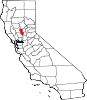 | |
| CDPs | ||
| Unincorporated communities | ||