
File:Donington as of 2006.svg

Size of this PNG preview of this SVG file: 800 × 555 pixels. Other resolutions: 320 × 222 pixels | 640 × 444 pixels | 1,024 × 710 pixels | 1,280 × 888 pixels | 2,560 × 1,776 pixels | 1,338 × 928 pixels.
Original file (SVG file, nominally 1,338 × 928 pixels, file size: 44 KB)
| This is a file from the Wikimedia Commons. Information from its description page there is shown below. Commons is a freely licensed media file repository. You can help. |
Summary
| Description |
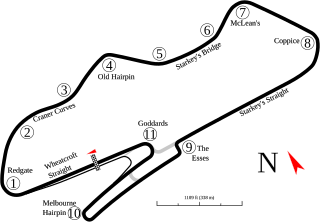
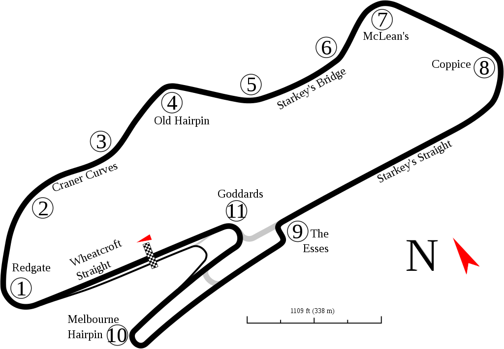
English: Track map for Donington Park as of 2006. This may or may not be the current version of the track. Changes are expected by w:2010. This is as shown in Google Earth as of the creation date. |
| Date | 9-2-2008 |
| Source | Own work |
| Author | Will Pittenger |
| Other versions |
Derivative works of this file: Donington as of 2010.svg
|

This W3C-unspecified vector image was created with Inkscape .
| Camera location | | View this and other nearby images on: OpenStreetMap |
|---|
Licensing
I, the copyright holder of this work, hereby publish it under the following license:
This file is licensed under the Creative Commons Attribution-Share Alike 3.0 Unported license.
- You are free:
- to share – to copy, distribute and transmit the work
- to remix – to adapt the work
- Under the following conditions:
- attribution – You must give appropriate credit, provide a link to the license, and indicate if changes were made. You may do so in any reasonable manner, but not in any way that suggests the licensor endorses you or your use.
- share alike – If you remix, transform, or build upon the material, you must distribute your contributions under the same or compatible license as the original.
File history
Click on a date/time to view the file as it appeared at that time.
| Date/Time | Thumbnail | Dimensions | User | Comment | |
|---|---|---|---|---|---|
| current | 18:04, 7 June 2016 | | 1,338 × 928 (44 KB) | Gpmat | Brigge→Bridge |
| 12:36, 2 September 2008 |  | 1,338 × 928 (44 KB) | Will Pittenger | Found that a name (for a straight) was missing and added that. | |
| 12:17, 2 September 2008 |  | 1,338 × 928 (42 KB) | Will Pittenger | {{Information |Description={{en|1=Track map for w:Donington Park as of w:2006. This may or may not be the current version of the track. Changes are expected by w:2010. This is as shown in Google Earth as of the creation date.}} |Source=Ow |
File usage
The following 2 pages use this file:
Global file usage
The following other wikis use this file:
- Usage on ar.wikipedia.org
- جائزة بريطانيا الكبرى للدراجات النارية 2002
- جائزة بريطانيا الكبرى للدراجات النارية 2003
- جائزة بريطانيا الكبرى للدراجات النارية 2004
- جائزة بريطانيا الكبرى للدراجات النارية 2005
- جائزة بريطانيا الكبرى للدراجات النارية 2008
- جائزة بريطانيا الكبرى للدراجات النارية 2009
- جائزة بريطانيا الكبرى للدراجات النارية 2006
- جائزة بريطانيا الكبرى للدراجات النارية 1988
- جائزة بريطانيا الكبرى للدراجات النارية 1989
- جائزة بريطانيا الكبرى للدراجات النارية 1990
- جائزة بريطانيا الكبرى للدراجات النارية 1991
- جائزة بريطانيا الكبرى للدراجات النارية 1992
- جائزة بريطانيا الكبرى للدراجات النارية 1993
- جائزة بريطانيا الكبرى للدراجات النارية 1994
- جائزة بريطانيا الكبرى للدراجات النارية 1995
- جائزة بريطانيا الكبرى للدراجات النارية 1996
- جائزة بريطانيا الكبرى للدراجات النارية 1997
- جائزة بريطانيا الكبرى للدراجات النارية 1998
- جائزة بريطانيا الكبرى للدراجات النارية 1999
- جائزة بريطانيا الكبرى للدراجات النارية 2000
- جائزة بريطانيا الكبرى للدراجات النارية 2001
- Usage on ast.wikipedia.org
- Usage on bg.wikipedia.org
- Usage on bn.wikipedia.org
- Usage on ca.wikipedia.org
- Usage on cs.wikipedia.org
- Usage on de.wikipedia.org
- Usage on en.wikipedia.org
- List of Formula One circuits
- European Grand Prix
- Donington Park
- 1993 European Grand Prix
- 1992 500 km of Donington
- 2006 1000 km of Donington
- 2001 ELMS at Donington Park
- 2003 FIA Sportscar Championship Donington
- 1988 British motorcycle Grand Prix
- 1989 British motorcycle Grand Prix
- 1990 British motorcycle Grand Prix
- 1991 British motorcycle Grand Prix
- 1992 British motorcycle Grand Prix
- 1993 British motorcycle Grand Prix
- 2007 Donington Park Superbike World Championship round
- 1990 480 km of Donington
- 1997 FIA GT Donington 4 Hours
- 2007 British motorcycle Grand Prix
- 1997 International Sports Racing Series Donington
- 2004 FIA GT Donington 500km
- 2003 FIA GT Donington 500km
View more global usage of this file.