
File:FeatherRiverMap.jpg

Size of this preview: 529 × 599 pixels. Other resolutions: 212 × 240 pixels | 424 × 480 pixels | 694 × 786 pixels.
Original file (694 × 786 pixels, file size: 245 KB, MIME type: image/jpeg)
| This is a file from the Wikimedia Commons. Information from its description page there is shown below. Commons is a freely licensed media file repository. You can help. |
Summary
| Description |
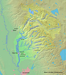
English: Partial map of the Feather River basin. For the actual shape of the perimeter, refer to the USGS maps for the 9 watersheds of the basin. |
||
| Date | |||
| Source | background layer from public-domain DEMIS Mapserver | ||
| Author | Shannon1 (coloring of basin, etc.) | ||
| Permission (Reusing this file) |
I, the copyright holder of this work, hereby publish it under the following licenses:
This file is licensed under the Creative Commons Attribution-Share Alike 4.0 International, 3.0 Unported, 2.5 Generic, 2.0 Generic and 1.0 Generic license.
You may select the license of your choice. |

File history
Click on a date/time to view the file as it appeared at that time.
| Date/Time | Thumbnail | Dimensions | User | Comment | |
|---|---|---|---|---|---|
| current | 21:16, 31 January 2015 | | 694 × 786 (245 KB) | Shannon1 | fixed bear and south yuba river course |
| 22:20, 8 August 2010 |  | 694 × 786 (244 KB) | Shannon1 | fixed some names, added cities, update generally | |
| 23:51, 29 January 2010 |  | 696 × 762 (310 KB) | Shannon1 | {{Information |Description={{en|1=Map of the Feather River watershed, CA}} |Source=Background from http://www2.demis.nl/mapserver/mapper.asp |Author=Background layer attributed to DEMIS Mapserver, modified by Shannon1 |Date=2010-01-29 |Permission=Map cre |
File usage
There are no pages that use this file.
Global file usage
The following other wikis use this file:
- Usage on de.wikipedia.org
- Usage on fr.wikipedia.org
- Usage on www.wikidata.org