
File:Ly-map.png
No higher resolution available.
Ly-map.png (326 × 350 pixels, file size: 9 KB, MIME type: image/png)
| This is a file from the Wikimedia Commons. Information from its description page there is shown below. Commons is a freely licensed media file repository. You can help. |
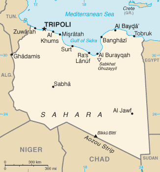
| Description | Libya | |||
| Source | CIA World Factbook | |||
| Author | CIA map | |||
| Other versions |
|


This image is in the public domain because it contains materials that originally came from the United States Central Intelligence Agency's World Factbook.
|
 |
File history
Click on a date/time to view the file as it appeared at that time.
| Date/Time | Thumbnail | Dimensions | User | Comment | |
|---|---|---|---|---|---|
| current | 19:03, 25 February 2011 | | 326 × 350 (9 KB) | Ras67 | cropped |
| 16:35, 7 August 2010 |  | 328 × 353 (13 KB) | ليبي صح | https://www.cia.gov/library/publications/the-world-factbook/maps/maptemplate_ly.html | |
| 21:02, 3 March 2005 |  | 330 × 353 (11 KB) | Alfio | CIA map of Libya |
File usage
The following page uses this file:
Global file usage
The following other wikis use this file:
- Usage on ar.wikipedia.org
- Usage on azb.wikipedia.org
- Usage on be-tarask.wikipedia.org
- Usage on bn.wikipedia.org
- Usage on bs.wikipedia.org
- Usage on ca.wikipedia.org
- Usage on ckb.wikipedia.org
- Usage on cs.wikinews.org
- Usage on da.wikipedia.org
- Usage on de.wikipedia.org
- Usage on de.wikinews.org
- Usage on diq.wikipedia.org
- Usage on dsb.wikipedia.org
- Usage on el.wikipedia.org
- Usage on el.wikinews.org
- Usage on en.wikipedia.org
- Usage on eo.wikipedia.org
- Usage on fa.wikipedia.org
- Usage on fi.wikipedia.org
- Usage on fi.wikinews.org
- Usage on fr.wikipedia.org
- Usage on gag.wikipedia.org
- Usage on gd.wikipedia.org
- Usage on gl.wikipedia.org
- Usage on he.wikipedia.org
- Usage on hif.wikipedia.org
View more global usage of this file.