
File:Map Gaels Brythons Picts patterns.png
Size of this preview: 563 × 600 pixels. Other resolutions: 225 × 240 pixels | 450 × 480 pixels | 778 × 829 pixels.
Original file (778 × 829 pixels, file size: 75 KB, MIME type: image/png)
| This is a file from the Wikimedia Commons. Information from its description page there is shown below. Commons is a freely licensed media file repository. You can help. |
| Description |
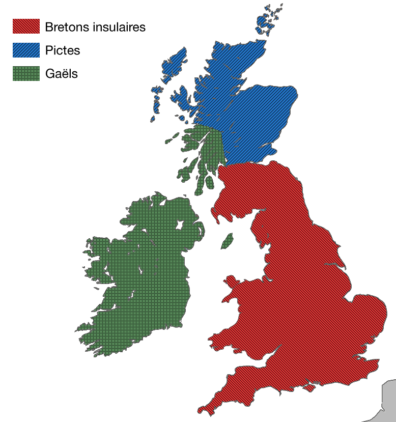
English: A map showing the approximate areas where the Gaelic (green), Brythonic (red) and Pictish (blue) languages were spoken around 450-500 CE. |
| Date | (UTC) |
| Source | |
| Author |
|
| This is a retouched picture, which means that it has been digitally altered from its original version. Modifications: Patterns added for increased accessibility. The original can be viewed here: Map Gaels Brythons Picts.png:
|
I, the copyright holder of this work, hereby publish it under the following licenses:
This file is licensed under the Creative Commons Attribution-Share Alike 3.0 Unported, 2.5 Generic, 2.0 Generic and 1.0 Generic license.
- You are free:
- to share – to copy, distribute and transmit the work
- to remix – to adapt the work
- Under the following conditions:
- attribution – You must give appropriate credit, provide a link to the license, and indicate if changes were made. You may do so in any reasonable manner, but not in any way that suggests the licensor endorses you or your use.
- share alike – If you remix, transform, or build upon the material, you must distribute your contributions under the same or compatible license as the original.

|
Permission is granted to copy, distribute and/or modify this document under the terms of the GNU Free Documentation License, Version 1.2 or any later version published by the Free Software Foundation; with no Invariant Sections, no Front-Cover Texts, and no Back-Cover Texts. A copy of the license is included in the section entitled GNU Free Documentation License. |
You may select the license of your choice.
Original upload log
This image is a derivative work of the following images:
- File:Map_Gaels_Brythons_Picts.png licensed with Cc-by-sa-3.0,2.5,2.0,1.0, GFDL
- 2009-03-27T04:37:32Z Asarlaí 643x829 (67122 Bytes) {{Information |Description={{en|1=A map showing the approximate areas where the Gaelic (green), Brythonic (red) and Pictish (blue) languages were spoken around 450-500 CE.}} |Source=Own work, based on [http://commons.wikimedi
Uploaded with derivativeFX
File history
Click on a date/time to view the file as it appeared at that time.
| Date/Time | Thumbnail | Dimensions | User | Comment | |
|---|---|---|---|---|---|
| current | 08:57, 22 August 2009 | | 778 × 829 (75 KB) | Aspérule | {{Information |Description={{en|1=A map showing the approximate areas where the Gaelic (green), Brythonic (red) and Pictish (blue) languages were spoken around 450-500 CE.}} |Source=*File:Map_Gaels_Brythons_Picts.png |Date=2009-08-22 08:56 (UTC) |Au |
File usage
The following page uses this file:
Global file usage
The following other wikis use this file:
- Usage on el.wikipedia.org
- Usage on fr.wikipedia.org
- Usage on he.wikipedia.org