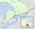
File:Ontario 401 map.svg

Size of this PNG preview of this SVG file: 512 × 389 pixels. Other resolutions: 316 × 240 pixels | 632 × 480 pixels | 1,011 × 768 pixels | 1,280 × 973 pixels | 2,560 × 1,945 pixels.
Original file (SVG file, nominally 512 × 389 pixels, file size: 360 KB)
File history
Click on a date/time to view the file as it appeared at that time.
| Date/Time | Thumbnail | Dimensions | User | Comment | |
|---|---|---|---|---|---|
| current | 21:50, 23 February 2021 |  | 512 × 389 (360 KB) | Floydian | fix whitespace |
| 21:11, 23 February 2021 |  | 512 × 391 (266 KB) | Floydian | fixes | |
| 19:56, 23 February 2021 |  | 512 × 391 (275 KB) | Floydian | Update for 2021 | |
| 21:27, 15 January 2014 |  | 900 × 750 (657 KB) | Floydian | Change colour of other freeways to match ONRD maps in other articles | |
| 18:20, 25 February 2012 |  | 900 × 750 (655 KB) | Floydian | fix inset colours | |
| 16:06, 25 February 2012 |  | 900 × 750 (655 KB) | Floydian | adjust | |
| 16:01, 25 February 2012 |  | 900 × 750 (655 KB) | Floydian | Canada inset for people who rely on an infobox picture to tell them the whole article | |
| 15:59, 25 February 2012 |  | 900 × 750 (655 KB) | Floydian | Canada inset for people who rely on an infobox picture to tell them the whole article | |
| 22:24, 25 May 2010 |  | 900 × 750 (576 KB) | Floydian | ||
| 03:18, 3 March 2010 |  | 1,060 × 810 (652 KB) | Floydian | {{Information |Description=A map of Ontario's 400-series freeways, with Provincial Highway 401 in orange. |Source=modified from File:Canada_Ontario_location_map.svg |Date=~~~~~ |Author=~~~ |Permission= |other_versions= }} [[Category:Maps of Ontario H |
File usage
The following page uses this file:
Global file usage
The following other wikis use this file:
- Usage on da.wikipedia.org
- Usage on de.wikipedia.org
- Usage on fa.wikipedia.org
- Usage on fi.wikipedia.org
- Usage on it.wikipedia.org
- Usage on ja.wikipedia.org
- Usage on no.wikipedia.org
- Usage on ru.wikipedia.org
- Usage on sk.wikipedia.org
- Usage on www.wikidata.org
- Usage on zh.wikipedia.org
