
File:Piri Reis map interpretation RG.jpg

Size of this preview: 744 × 600 pixels. Other resolutions: 298 × 240 pixels | 595 × 480 pixels.
Original file (800 × 645 pixels, file size: 187 KB, MIME type: image/jpeg)
| This is a file from the Wikimedia Commons. Information from its description page there is shown below. Commons is a freely licensed media file repository. You can help. |
Summary
| Description |
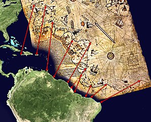
English: Possible interpretation of the Piri Reis map. Middle and south america on the left, north africa in the upper right, south atlantic ocean in the middle.
An alternate (and more likely) interpretation of those ancient map can be found here: File:Piri Reis map interpretation.jpg |
| Date | |
| Source | Own work, based on de:Datei:Karte des piri reis.jpg and File:Whole world - land and oceans.jpg. Both sources are public domain. |
| Author | TMg, based on an image by Segantini. |
| Other versions |
|

Licensing
| I, the copyright holder of this work, release this work into the public domain. This applies worldwide. In some countries this may not be legally possible; if so: I grant anyone the right to use this work for any purpose, without any conditions, unless such conditions are required by law. |
File history
Click on a date/time to view the file as it appeared at that time.
| Date/Time | Thumbnail | Dimensions | User | Comment | |
|---|---|---|---|---|---|
| current | 20:32, 29 March 2006 | | 800 × 645 (187 KB) | TMg | == Beschreibung == {{Information| |Description = Possible interpretation of the Piri Reis map. Middle and south america on the left, north africa in the upper right, south [[w |
File usage
The following page uses this file:
Global file usage
The following other wikis use this file:
- Usage on ar.wikipedia.org
- Usage on ca.wikipedia.org
- Usage on de.wikipedia.org
- Usage on el.wikipedia.org
- Usage on es.wikipedia.org
- Usage on gl.wikipedia.org
- Usage on hu.wikipedia.org