
List of municipalities in New Jersey
This is a list of the 564[1] municipalities in the U.S. state of New Jersey, ordered by population. There are five types of municipality in the state:
New Jersey covers 8,722 square miles (22,590 km2). That makes the average land size of a municipality in the state about 15 square miles (39 km2). However, but note in the map at right that the sizes are very different.

All land within New Jersey is in a municipality.
List of municipalities[change | change source]
- Largest municipalities in New Jersey by population
-
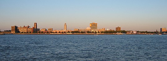
 Newark, New Jersey's largest city by population
 -
 Jersey City, New Jersey's second-largest city by population
 -
 Paterson, New Jersey's third-largest city by population
 -
 Elizabeth, New Jersey's fourth-largest city by population
 -
 Trenton, the state capital of New Jersey
 -
 Camden, the largest city in South Jersey by population


| Name | Type | County | Population (2020)[2] | Population (2010)[3] | Change | Land area[2] | Population density[2] | Form of government | Incorporated[4] | |
|---|---|---|---|---|---|---|---|---|---|---|
| sq mi | km2 | |||||||||
| Newark | City | Essex | 311,549 | 277,140 | +12.4% | 24.144 | 62.53 | 12,903.8/sq mi (4,982.2/km2) | Faulkner Act (mayor–council) | 1693[note 1] |
| Jersey City | City | Hudson | 292,449 | 247,597 | +18.1% | 14.744 | 38.19 | 19,835.1/sq mi (7,658.4/km2) | Faulkner Act (mayor–council) | 1838 |
| Paterson | City | Passaic | 159,732 | 146,199 | +9.3% | 8.413 | 21.79 | 18,986.3/sq mi (7,330.7/km2) | Faulkner Act (mayor–council) | 1831[note 2] |
| Elizabeth | City | Union | 137,298 | 124,969 | +9.9% | 12.319 | 31.91 | 11,145.2/sq mi (4,303.2/km2) | Faulkner Act (mayor–council) | 1855 |
| Lakewood Township | Township | Ocean | 135,158 | 92,843 | +45.6% | 24.681 | 63.92 | 5,476.2/sq mi (2,114.4/km2) | Township (New Jersey) | 1892 |
| Edison | Township | Middlesex | 107,588 | 99,967 | +7.6% | 30.068 | 77.88 | 3,578.2/sq mi (1,381.6/km2) | Faulkner Act (mayor–council) | 1870[note 3] |
| Woodbridge Township | Township | Middlesex | 103,639 | 99,585 | +4.1% | 23.258 | 60.24 | 4,456.1/sq mi (1,720.5/km2) | Faulkner Act (mayor–council) | 1798 |
| Toms River | Township | Ocean | 95,438 | 91,239 | +4.6% | 40.541 | 105.00 | 2,354.1/sq mi (908.9/km2) | Faulkner Act (mayor–council) | 1798[note 4] |
| Hamilton Township | Township | Mercer | 92,297 | 88,464 | +4.3% | 39.438 | 102.14 | 2,340.3/sq mi (903.6/km2) | Faulkner Act (mayor–council) | 1842 |
| Trenton | City | Mercer | 90,871 | 84,913 | +7.0% | 7.579 | 19.63 | 11,989.8/sq mi (4,629.3/km2) | Faulkner Act (mayor–council) | 1792 |
| Clifton | City | Passaic | 90,296 | 84,136 | +7.3% | 11.275 | 29.20 | 8,008.5/sq mi (3,092.1/km2) | 1923 Municipal Manager Law | 1917 |
| Cherry Hill Township | Township | Camden | 74,553 | 71,045 | +4.9% | 24.072 | 62.35 | 3,097.1/sq mi (1,195.8/km2) | Faulkner Act (mayor–council) | 1844[note 5] |
| Brick Township | Township | Ocean | 73,620 | 75,072 | −1.9% | 25.587 | 66.27 | 2,877.2/sq mi (1,110.9/km2) | Faulkner Act (mayor–council) | 1850 |
| Camden | City | Camden | 71,791 | 77,344 | −7.2% | 8.921 | 23.11 | 8,047.4/sq mi (3,107.1/km2) | Faulkner Act (mayor–council) | 1828 |
| Bayonne | City | Hudson | 71,686 | 63,024 | +13.7% | 5.821 | 15.08 | 12,315.1/sq mi (4,754.9/km2) | Faulkner Act (mayor–council) | 1861[note 6] |
| Passaic | City | Passaic | 70,537 | 69,781 | +1.1% | 3.133 | 8.11 | 22,514.2/sq mi (8,692.8/km2) | Faulkner Act (mayor–council) | 1873 |
| East Orange | City | Essex | 69,612 | 64,270 | +8.3% | 3.928 | 10.17 | 17,722.0/sq mi (6,842.5/km2) | City (New Jersey) | 1863 |
| Union City | City | Hudson | 68,589 | 66,455 | +3.2% | 1.287 | 3.33 | 53,293.7/sq mi (20,576.8/km2) | Walsh Act | 1925 |
| Franklin Township | Township | Somerset | 68,364 | 62,300 | +9.7% | 46.170 | 119.58 | 1,480.7/sq mi (571.7/km2) | Faulkner Act (council–manager) | 1798 |
| Middletown Township | Township | Monmouth | 67,106 | 66,522 | +0.9% | 40.949 | 106.06 | 1,638.8/sq mi (632.7/km2) | Special charter (New Jersey) | 1798 |
| Old Bridge Township | Township | Middlesex | 66,876 | 65,375 | +2.3% | 38.181 | 98.89 | 1,751.6/sq mi (676.3/km2) | Faulkner Act (mayor–council) | 1869[note 7] |
| Gloucester Township | Township | Camden | 66,034 | 64,634 | +2.2% | 22.954 | 59.45 | 2,876.8/sq mi (1,110.7/km2) | Faulkner Act (mayor–council) | 1798 |
| North Bergen | Township | Hudson | 63,361 | 60,773 | +4.3% | 5.136 | 13.30 | 12,336.6/sq mi (4,763.2/km2) | Walsh Act | 1843 |
| Irvington | Township | Essex | 61,176 | 53,926 | +13.4% | 2.914 | 7.55 | 20,993.8/sq mi (8,105.8/km2) | Faulkner Act (mayor–council) | 1874 |
| Piscataway | Township | Middlesex | 60,804 | 56,044 | +8.5% | 18.794 | 48.68 | 3,235.3/sq mi (1,249.2/km2) | Faulkner Act (mayor–council) | 1798 |
| Vineland | City | Cumberland | 60,780 | 60,724 | +0.1% | 68.393 | 177.14 | 888.7/sq mi (343.1/km2) | Faulkner Act (mayor–council) | 1952 |
| Hoboken | City | Hudson | 60,419 | 50,005 | +20.8% | 1.250 | 3.24 | 48,335.2/sq mi (18,662.3/km2) | Faulkner Act (mayor–council) | 1849 |
| Union Township | Township | Union | 59,728 | 56,642 | +5.4% | 9.051 | 23.44 | 6,599.0/sq mi (2,547.9/km2) | Township (New Jersey) | 1808 |
| Jackson Township | Township | Ocean | 58,544 | 54,856 | +6.7% | 99.174 | 256.86 | 590.3/sq mi (227.9/km2) | Faulkner Act (mayor–council) | 1844 |
| Parsippany-Troy Hills | Township | Morris | 56,162 | 53,238 | +5.5% | 23.632 | 61.21 | 2,376.5/sq mi (917.6/km2) | Faulkner Act (mayor–council) | 1928 |
| Perth Amboy | City | Middlesex | 55,436 | 50,814 | +9.1% | 4.662 | 12.07 | 11,891.0/sq mi (4,591.1/km2) | Faulkner Act (mayor–council) | 1718 |
| New Brunswick | City | Middlesex | 55,266 | 55,181 | +0.2% | 5.233 | 13.55 | 10,561.1/sq mi (4,077.7/km2) | Faulkner Act (mayor–council) | 1784 |
| Wayne | Township | Passaic | 54,838 | 54,717 | +0.2% | 23.722 | 61.44 | 2,311.7/sq mi (892.6/km2) | Faulkner Act (mayor–council) | 1847 |
| Plainfield | City | Union | 54,586 | 49,808 | +9.6% | 5.959 | 15.43 | 9,160.3/sq mi (3,536.8/km2) | Special charter (New Jersey) | 1869 |
| Howell Township | Township | Monmouth | 53,537 | 51,075 | +4.8% | 60.271 | 156.10 | 888.3/sq mi (343.0/km2) | Faulkner Act (council–manager) | 1801 |
| Bloomfield | Township | Essex | 53,105 | 47,315 | +12.2% | 5.337 | 13.82 | 9,950.3/sq mi (3,841.8/km2) | Special charter (New Jersey) | 1812 |
| West New York | Town | Hudson | 52,912 | 49,708 | +6.4% | 0.994 | 2.57 | 53,231.4/sq mi (20,552.8/km2) | Walsh Act | 1898 |
| East Brunswick | Township | Middlesex | 49,715 | 47,512 | +4.6% | 21.784 | 56.42 | 2,282.2/sq mi (881.2/km2) | Faulkner Act (mayor–council) | 1860 |
| West Orange | Township | Essex | 48,843 | 46,207 | +5.7% | 12.003 | 31.09 | 4,069.2/sq mi (1,571.1/km2) | Faulkner Act (mayor–council) | 1863 |
| Washington Township | Township | Gloucester | 48,677 | 48,559 | +0.2% | 21.346 | 55.29 | 2,280.4/sq mi (880.5/km2) | Faulkner Act (mayor–council) | 1836 |
| Monroe Township | Township | Middlesex | 48,594 | 39,132 | +24.2% | 41.943 | 108.63 | 1,158.6/sq mi (447.3/km2) | Faulkner Act (mayor–council) | 1838 |
| Egg Harbor Township | Township | Atlantic | 47,842 | 43,323 | +10.4% | 67.047 | 173.65 | 713.6/sq mi (275.5/km2) | Township (New Jersey) | 1798 |
| South Brunswick | Township | Middlesex | 47,043 | 43,417 | +8.4% | 40.614 | 105.19 | 1,158.3/sq mi (447.2/km2) | Faulkner Act (council–manager) | 1798 |
| Evesham Township | Township | Burlington | 46,826 | 45,538 | +2.8% | 29.156 | 75.51 | 1,606.1/sq mi (620.1/km2) | Faulkner Act (council–manager) | 1798 |
| Hackensack | City | Bergen | 46,030 | 43,010 | +7.0% | 4.191 | 10.85 | 10,983.1/sq mi (4,240.6/km2) | 1923 Municipal Manager Law | 1693[note 8] |
| Bridgewater Township | Township | Somerset | 45,977 | 44,464 | +3.4% | 31.888 | 82.59 | 1,441.8/sq mi (556.7/km2) | Faulkner Act (mayor–council) | 1798 |
| Sayreville | Borough | Middlesex | 45,345 | 42,704 | +6.2% | 15.830 | 41.00 | 2,864.5/sq mi (1,106.0/km2) | Borough (New Jersey) | 1876[note 9] |
| Manchester Township | Township | Ocean | 45,115 | 43,070 | +4.7% | 81.417 | 210.87 | 554.1/sq mi (213.9/km2) | Faulkner Act (mayor–council) | 1865 |
| Mount Laurel | Township | Burlington | 44,633 | 41,864 | +6.6% | 21.724 | 56.26 | 2,054.5/sq mi (793.2/km2) | Faulkner Act (council–manager) | 1872 |
| North Brunswick | Township | Middlesex | 43,905 | 40,742 | +7.8% | 12.032 | 31.16 | 3,649.0/sq mi (1,408.9/km2) | Faulkner Act (mayor–council–administrator) | 1798 |
| Berkeley Township | Township | Ocean | 43,754 | 41,255 | +6.1% | 42.710 | 110.62 | 1,024.4/sq mi (395.5/km2) | Faulkner Act (mayor–council) | 1875 |
| Linden | City | Union | 43,738 | 40,499 | +8.0% | 10.688 | 27.68 | 4,092.3/sq mi (1,580.0/km2) | City (New Jersey) | 1925 |
| Hillsborough Township | Township | Somerset | 43,276 | 38,303 | +13.0% | 54.614 | 141.45 | 792.4/sq mi (305.9/km2) | Township (New Jersey) | 1771 |
| Kearny | Town | Hudson | 41,999 | 40,684 | +3.2% | 8.844 | 22.91 | 4,748.9/sq mi (1,833.6/km2) | Town (New Jersey) | 1867 |
| Marlboro Township | Township | Monmouth | 41,502 | 40,191 | +3.3% | 30.340 | 78.58 | 1,367.9/sq mi (528.1/km2) | Faulkner Act (mayor–council) | 1848 |
| Teaneck | Township | Bergen | 41,246 | 39,776 | +3.7% | 6.041 | 15.65 | 6,827.7/sq mi (2,636.2/km2) | Faulkner Act (council–manager) | 1895 |
| Montclair | Township | Essex | 40,921 | 37,669 | +8.6% | 6.238 | 16.16 | 6,560.0/sq mi (2,532.8/km2) | Faulkner Act (council–manager) | 1868 |
| Manalapan Township | Township | Monmouth | 40,905 | 38,872 | +5.2% | 30.651 | 79.39 | 1,334.5/sq mi (515.3/km2) | Township (New Jersey) | 1848 |
| Fort Lee | Borough | Bergen | 40,191 | 35,345 | +13.7% | 2.518 | 6.52 | 15,961.5/sq mi (6,162.8/km2) | Borough (New Jersey) | 1904 |
| Winslow Township | Township | Camden | 39,907 | 39,499 | +1.0% | 57.417 | 148.71 | 695.0/sq mi (268.3/km2) | Township (New Jersey) | 1845 |
| Atlantic City | City | Atlantic | 38,497 | 39,558 | −2.7% | 10.760 | 27.87 | 3,577.8/sq mi (1,381.4/km2) | Faulkner Act (mayor–council) | 1854 |
| Belleville | Township | Essex | 38,222 | 35,926 | +6.4% | 3.296 | 8.54 | 11,596.5/sq mi (4,477.4/km2) | Faulkner Act (council–manager) | 1839 |
| Galloway Township | Township | Atlantic | 37,813 | 37,349 | +1.2% | 88.668 | 229.65 | 426.5/sq mi (164.7/km2) | Faulkner Act (council–manager) | 1798 |
| Ewing Township | Township | Mercer | 37,264 | 35,790 | +4.1% | 15.206 | 39.38 | 2,450.6/sq mi (946.2/km2) | Faulkner Act (mayor–council) | 1834 |
| Monroe Township | Township | Gloucester | 37,117 | 36,129 | +2.7% | 46.421 | 120.23 | 799.6/sq mi (308.7/km2) | Faulkner Act (mayor–council) | 1859 |
| Pennsauken Township | Township | Camden | 37,074 | 35,885 | +3.3% | 10.479 | 27.14 | 3,537.9/sq mi (1,366.0/km2) | Township (New Jersey) | 1892 |
| Freehold Township | Township | Monmouth | 35,369 | 36,184 | −2.3% | 38.653 | 100.11 | 915.0/sq mi (353.3/km2) | Township (New Jersey) | 1798 |
| Fair Lawn | Borough | Bergen | 34,927 | 32,457 | +7.6% | 5.135 | 13.30 | 6,801.8/sq mi (2,626.2/km2) | Faulkner Act (council–manager) | 1924 |
| Orange | Township | Essex | 34,447 | 30,134 | +14.3% | 2.213 | 5.73 | 15,565.7/sq mi (6,010.0/km2) | Faulkner Act (mayor–council) | 1806 |
| Lawrence Township | Township | Mercer | 33,077 | 33,472 | −1.2% | 21.725 | 56.27 | 1,522.5/sq mi (587.8/km2) | Faulkner Act (council–manager) | 1798[note 10] |
| Garfield | City | Bergen | 32,655 | 30,487 | +7.1% | 2.111 | 5.47 | 15,469.0/sq mi (5,972.6/km2) | 1923 Municipal Manager Law | 1898[note 11] |
| Deptford Township | Township | Gloucester | 31,977 | 30,561 | +4.6% | 17.331 | 44.89 | 1,845.1/sq mi (712.4/km2) | Faulkner Act (council–manager) | 1798 |
| Willingboro Township | Township | Burlington | 31,889 | 31,629 | +0.8% | 7.725 | 20.01 | 4,128.0/sq mi (1,593.8/km2) | Faulkner Act (council–manager) | 1798 |
| Long Branch | City | Monmouth | 31,667 | 30,719 | +3.1% | 5.124 | 13.27 | 6,180.1/sq mi (2,386.1/km2) | Faulkner Act (mayor–council) | 1867[note 12] |
| Livingston | Township | Essex | 31,330 | 29,366 | +6.7% | 13.785 | 35.70 | 2,272.8/sq mi (877.5/km2) | Faulkner Act (council–manager) | 1813 |
| Voorhees Township | Township | Camden | 31,069 | 29,131 | +6.7% | 11.471 | 29.71 | 2,708.5/sq mi (1,045.8/km2) | Township (New Jersey) | 1899 |
| Westfield | Town | Union | 31,032 | 30,316 | +2.4% | 6.724 | 17.42 | 4,615.1/sq mi (1,781.9/km2) | Special charter (New Jersey) | 1798[note 13] |
| Princeton | Borough | Mercer | 30,681 | 28,400 | +8.0% | 17.946 | 46.48 | 1,709.6/sq mi (660.1/km2) | Borough (New Jersey) | 1813/2013[note 14] |
| Nutley | Township | Essex | 30,143 | 28,117 | +7.2% | 3.372 | 8.73 | 8,939.2/sq mi (3,451.4/km2) | Walsh Act | 1874[note 15] |
| East Windsor Township | Township | Mercer | 30,045 | 27,165 | +10.6% | 15.567 | 40.32 | 1,930.0/sq mi (745.2/km2) | Faulkner Act (council–manager) | 1798 |
| Rahway | City | Union | 29,556 | 27,291 | +8.3% | 3.896 | 10.09 | 7,586.2/sq mi (2,929.0/km2) | Faulkner Act (mayor–council) | 1858 |
| West Windsor | Township | Mercer | 29,518 | 27,147 | +8.7% | 25.549 | 66.17 | 1,155.3/sq mi (446.1/km2) | Faulkner Act (mayor–council) | 1798 |
| Englewood | City | Bergen | 29,308 | 26,764 | +9.5% | 4.925 | 12.76 | 5,950.9/sq mi (2,297.7/km2) | Special charter (New Jersey) | 1899 |
| Mount Olive Township | Township | Morris | 28,886 | 27,935 | +3.4% | 29.617 | 76.71 | 975.3/sq mi (376.6/km2) | Faulkner Act (mayor–council) | 1871 |
| Lacey Township | Township | Ocean | 28,655 | 27,346 | +4.8% | 83.248 | 215.61 | 344.2/sq mi (132.9/km2) | Township (New Jersey) | 1871 |
| Stafford Township | Township | Ocean | 28,617 | 26,503 | +8.0% | 46.114 | 119.43 | 620.6/sq mi (239.6/km2) | Faulkner Act (small municipality) | 1798 |
| Bergenfield | Borough | Bergen | 28,321 | 26,652 | +6.3% | 2.904 | 7.52 | 9,752.4/sq mi (3,765.4/km2) | Borough (New Jersey) | 1894 |
| Neptune Township | Township | Monmouth | 28,061 | 27,912 | +0.5% | 8.127 | 21.05 | 3,452.8/sq mi (1,333.1/km2) | Township (New Jersey) | 1879 |
| Bernards Township | Township | Somerset | 27,830 | 26,535 | +4.9% | 24.201 | 62.68 | 1,150.0/sq mi (444.0/km2) | Township (New Jersey) | 1798 |
| Ocean Township | Township | Monmouth | 27,672 | 27,190 | +1.8% | 10.867 | 28.15 | 2,546.4/sq mi (983.2/km2) | Faulkner Act (council–manager) | 1849 |
| Millville | City | Cumberland | 27,491 | 28,370 | −3.1% | 41.999 | 108.78 | 654.6/sq mi (252.7/km2) | Walsh Act | 1801[note 16] |
| Hamilton Township | Township | Atlantic | 27,484 | 26,342 | +4.3% | 110.895 | 287.22 | 247.8/sq mi (95.7/km2) | Township (New Jersey) | 1813 |
| Bridgeton | City | Cumberland | 27,263 | 24,958 | +9.2% | 6.228 | 16.13 | 4,377.5/sq mi (1,690.2/km2) | Faulkner Act (mayor–council) | 1865 |
| Pemberton Township | Township | Burlington | 26,903 | 27,644 | −2.7% | 61.556 | 159.43 | 437.0/sq mi (168.7/km2) | Faulkner Act (mayor–council) | 1846 |
| Paramus | Borough | Bergen | 26,698 | 26,164 | +2.0% | 10.445 | 27.05 | 2,556.1/sq mi (986.9/km2) | Borough (New Jersey) | 1922 |
| Wall Township | Township | Monmouth | 26,525 | 25,890 | +2.5% | 30.659 | 79.41 | 865.2/sq mi (334.1/km2) | Township (New Jersey) | 1851 |
| Randolph | Township | Morris | 26,504 | 25,349 | +4.6% | 20.905 | 54.14 | 1,267.8/sq mi (489.5/km2) | Faulkner Act (council–manager) | 1806 |
| Lodi | Borough | Bergen | 26,206 | 23,943 | +9.5% | 2.272 | 5.88 | 11,534.3/sq mi (4,453.4/km2) | 1923 Municipal Manager Law | 1894 |
| Ridgewood | Village | Bergen | 25,979 | 24,156 | +7.5% | 5.742 | 14.87 | 4,524.4/sq mi (1,746.9/km2) | Faulkner Act (council–manager) | 1894 |
| Cliffside Park | Borough | Bergen | 25,693 | 23,510 | +9.3% | 0.956 | 2.48 | 26,875.5/sq mi (10,376.7/km2) | 1895 | |
| Maplewood | Township | Essex | 25,684 | 23,594 | +8.9% | 3.874 | 10.03 | 6,629.8/sq mi (2,559.8/km2) | 1861[note 17] | |
| Mahwah | Township | Bergen | 25,487 | 25,850 | −1.4% | 25.392 | 65.76 | 1,003.7/sq mi (387.5/km2) | Faulkner Act (mayor–council) | 1849[note 18] |
| Rockaway Township | Township | Morris | 25,341 | 24,136 | +5.0% | 41.733 | 108.09 | 607.2/sq mi (234.4/km2) | Faulkner Act (mayor–council) | 1844 |
| Carteret | Borough | Middlesex | 25,326 | 22,625 | +11.9% | 4.391 | 11.37 | 5,767.7/sq mi (2,226.9/km2) | 1906[note 19] | |
| Scotch Plains | Township | Union | 24,968 | 23,385 | +6.8% | 9.021 | 23.36 | 2,767.8/sq mi (1,068.7/km2) | Faulkner Act (council–manager) | 1878[note 20] |
| West Milford | Township | Passaic | 24,862 | 25,734 | −3.4% | 75.932 | 196.66 | 327.4/sq mi (126.4/km2) | Faulkner Act (mayor–council–administrator) | 1834 |
| Medford | Township | Burlington | 24,497 | 22,999 | +6.5% | 38.799 | 100.49 | 631.4/sq mi (243.8/km2) | Faulkner Act (council–manager) | 1847 |
| South Plainfield | Borough | Middlesex | 24,338 | 23,324 | +4.3% | 8.296 | 21.49 | 2,933.7/sq mi (1,132.7/km2) | 1926 | |
| Barnegat Township | Township | Ocean | 24,296 | 20,726 | +17.2% | 34.239 | 88.68 | 709.6/sq mi (274.0/km2) | 1846[note 21] | |
| Plainsboro Township | Township | Middlesex | 24,084 | 22,866 | +5.3% | 11.738 | 30.40 | 2,051.8/sq mi (792.2/km2) | 1919 | |
| Burlington Township | Township | Burlington | 23,983 | 22,306 | +7.5% | 13.476 | 34.90 | 1,779.7/sq mi (687.1/km2) | 1798 | |
| Cranford | Township | Union | 23,847 | 22,594 | +5.5% | 4.835 | 12.52 | 4,932.2/sq mi (1,904.3/km2) | 1871 | |
| Montgomery Township | Township | Somerset | 23,690 | 22,185 | +6.8% | 32.300 | 83.66 | 733.4/sq mi (283.2/km2) | 1798 | |
| Raritan Township | Township | Hunterdon | 23,447 | 21,936 | +6.9% | 37.482 | 97.08 | 625.6/sq mi (241.5/km2) | 1838 | |
| Glassboro | Borough | Gloucester | 23,149 | 18,533 | +24.9% | 9.320 | 24.14 | 2,483.8/sq mi (959.0/km2) | 1878 | |
| Morris Township | Township | Morris | 22,974 | 22,254 | +3.2% | 15.682 | 40.62 | 1,465.0/sq mi (565.6/km2) | 1798 | |
| Roxbury | Township | Morris | 22,950 | 23,033 | −0.4% | 20.852 | 54.01 | 1,100.6/sq mi (424.9/km2) | Faulkner Act (council–manager) | 1798 |
| North Plainfield | Borough | Somerset | 22,808 | 21,677 | +5.2% | 2.807 | 7.27 | 8,125.4/sq mi (3,137.2/km2) | 1885 | |
| Summit | City | Union | 22,719 | 21,404 | +6.1% | 5.994 | 15.52 | 3,790.3/sq mi (1,463.4/km2) | City (New Jersey) | 1899 |
| Roselle | Borough | Union | 22,695 | 20,936 | +8.4% | 2.635 | 6.82 | 8,612.9/sq mi (3,325.5/km2) | 1894 | |
| Lyndhurst | Township | Bergen | 22,519 | 20,334 | +10.7% | 4.584 | 11.87 | 4,912.5/sq mi (1,896.7/km2) | Walsh Act | 1852[note 22] |
| Hillside | Township | Union | 22,456 | 21,314 | +5.4% | 2.767 | 7.17 | 8,115.6/sq mi (3,133.5/km2) | 1913 | |
| Montville | Township | Morris | 22,450 | 21,457 | +4.6% | 18.627 | 48.24 | 1,205.2/sq mi (465.3/km2) | Special charter (New Jersey) | 1867 |
| Vernon Township | Township | Sussex | 22,358 | 23,867 | −6.3% | 67.595 | 175.07 | 330.8/sq mi (127.7/km2) | Faulkner Act (mayor–council)[6] | 1798 |
| West Deptford Township | Township | Gloucester | 22,197 | 21,528 | +3.1% | 15.357 | 39.77 | 1,445.4/sq mi (558.1/km2) | 1871 | |
| Secaucus | Town | Hudson | 22,181 | 16,198 | +36.9% | 5.826 | 15.09 | 3,807.2/sq mi (1,470.0/km2) | Town (New Jersey) | 1900 |
| Lower Township | Township | Cape May | 22,057 | 22,844 | −3.4% | 27.378 | 70.91 | 805.6/sq mi (311.0/km2) | Faulkner Act (council–manager) | 1798 |
| Millburn | Township | Essex | 21,710 | 20,065 | +8.2% | 9.333 | 24.17 | 2,326.2/sq mi (898.2/km2) | 1857 | |
| Lindenwold | Borough | Camden | 21,641 | 17,479 | +23.8% | 3.902 | 10.11 | 5,546.1/sq mi (2,141.4/km2) | 1929 | |
| Elmwood Park | Borough | Bergen | 21,422 | 19,131 | +12.0% | 2.643 | 6.85 | 8,105.2/sq mi (3,129.4/km2) | 1916[note 23] | |
| Moorestown | Township | Burlington | 21,355 | 20,554 | +3.9% | 14.729 | 38.15 | 1,449.9/sq mi (559.8/km2) | Faulkner Act (council–manager) | 1922 |
| Little Egg Harbor Township | Township | Ocean | 20,784 | 19,722 | +5.4% | 47.346 | 122.63 | 439.0/sq mi (169.5/km2) | 1798 | |
| Pleasantville | City | Atlantic | 20,629 | 20,149 | +2.4% | 5.721 | 14.82 | 3,605.8/sq mi (1,392.2/km2) | City (New Jersey) | 1889 |
| Jefferson Township | Township | Morris | 20,538 | 21,085 | −2.6% | 38.903 | 100.76 | 527.9/sq mi (203.8/km2) | 1804 | |
| Middle Township | Township | Cape May | 20,380 | 18,791 | +8.5% | 70.238 | 181.92 | 290.2/sq mi (112.0/km2) | 1798 | |
| Palisades Park | Borough | Bergen | 20,292 | 19,403 | +4.6% | 1.239 | 3.21 | 16,377.7/sq mi (6,323.5/km2) | 1899 | |
| Morristown | Town | Morris | 20,180 | 18,392 | +9.7% | 2.909 | 7.53 | 6,937.1/sq mi (2,678.4/km2) | Faulkner Act (mayor–council) | 1865 |
| Hazlet | Township | Monmouth | 20,125 | 20,249 | −0.6% | 5.569 | 14.42 | 3,613.8/sq mi (1,395.3/km2) | 1848[note 24] | |
| Maple Shade Township | Township | Burlington | 19,980 | 18,911 | +5.7% | 3.827 | 9.91 | 5,220.8/sq mi (2,015.8/km2) | Faulkner Act (council–manager) | 1798[note 25] |
| Hawthorne | Borough | Passaic | 19,637 | 18,579 | +5.7% | 3.318 | 8.59 | 5,918.3/sq mi (2,285.1/km2) | 1898 | |
| Sparta | Township | Sussex | 19,600 | 19,622 | −0.1% | 36.788 | 95.28 | 532.8/sq mi (205.7/km2) | Faulkner Act (council–manager) | 1845 |
| Harrison | Town | Hudson | 19,450 | 13,574 | +43.3% | 1.211 | 3.14 | 16,061.1/sq mi (6,201.2/km2) | Town (New Jersey) | 1840 |
| Aberdeen Township | Township | Monmouth | 19,329 | 18,157 | +6.5% | 5.444 | 14.10 | 3,550.5/sq mi (1,370.9/km2) | Faulkner Act (council–manager) | 1857[note 26] |
| Tinton Falls | Borough | Monmouth | 19,181 | 17,613 | +8.9% | 15.475 | 40.08 | 1,239.5/sq mi (478.6/km2) | 1950[note 27] | |
| Point Pleasant | Borough | Ocean | 18,941 | 18,210 | +4.0% | 3.491 | 9.04 | 5,425.7/sq mi (2,094.9/km2) | 1920 | |
| Rutherford | Borough | Bergen | 18,834 | 17,892 | +5.3% | 2.781 | 7.20 | 6,772.4/sq mi (2,614.8/km2) | 1881 | |
| South Orange | Township | Essex | 18,484 | 16,126 | +14.6% | 2.846 | 7.37 | 6,494.7/sq mi (2,507.6/km2) | Special charter (New Jersey) | 1869 |
| Dover | Town | Morris | 18,460 | 18,061 | +2.2% | 2.676 | 6.93 | 6,898.4/sq mi (2,663.5/km2) | Town (New Jersey) | 1896 |
| Washington Township | Township | Morris | 18,197 | 18,411 | −1.2% | 44.582 | 115.47 | 408.2/sq mi (157.6/km2) | 1798 | |
| Delran Township | Township | Burlington | 17,882 | 16,820 | +6.3% | 6.630 | 17.17 | 2,697.1/sq mi (1,041.4/km2) | 1880 | |
| Dumont | Borough | Bergen | 17,863 | 17,304 | +3.2% | 1.949 | 5.05 | 9,165.2/sq mi (3,538.7/km2) | 1894 | |
| Hopewell Township | Township | Mercer | 17,491 | 16,896 | +3.5% | 58.071 | 150.40 | 301.2/sq mi (116.3/km2) | 1798 | |
| Holmdel Township | Township | Monmouth | 17,400 | 16,696 | +4.2% | 17.847 | 46.22 | 975.0/sq mi (376.4/km2) | 1857 | |
| Weehawken | Township | Hudson | 17,197 | 12,417 | +38.5% | 0.784 | 2.03 | 21,934.9/sq mi (8,469.1/km2) | Faulkner Act (council–manager) | 1859 |
| Springfield Township | Township | Union | 17,178 | 15,569 | +10.3% | 5.157 | 13.36 | 3,331.0/sq mi (1,286.1/km2) | 1798 | |
| Denville Township | Township | Morris | 17,107 | 16,341 | +4.7% | 11.992 | 31.06 | 1,426.5/sq mi (550.8/km2) | 1913 | |
| Cinnaminson Township | Township | Burlington | 17,064 | 15,540 | +9.8% | 7.424 | 19.23 | 2,298.5/sq mi (887.5/km2) | 1860 | |
| Madison | Borough | Morris | 16,937 | 15,817 | +7.1% | 4.313 | 11.17 | 3,927.0/sq mi (1,516.2/km2) | 1889 | |
| New Milford | Borough | Bergen | 16,923 | 16,264 | +4.1% | 2.283 | 5.91 | 7,412.6/sq mi (2,862.0/km2) | 1922 | |
| Wyckoff | Township | Bergen | 16,585 | 16,635 | −0.3% | 6.591 | 17.07 | 2,516.3/sq mi (971.5/km2) | 1926 | |
| North Arlington | Borough | Bergen | 16,457 | 15,311 | +7.5% | 2.484 | 6.43 | 6,625.2/sq mi (2,558.0/km2) | 1896 | |
| Franklin Township | Township | Gloucester | 16,380 | 16,773 | −2.3% | 55.830 | 144.60 | 293.4/sq mi (113.3/km2) | 1820 | |
| Readington Township | Township | Hunterdon | 16,128 | 16,116 | +0.1% | 47.558 | 123.17 | 339.1/sq mi (130.9/km2) | 1798 | |
| South River | Borough | Middlesex | 16,118 | 15,845 | +1.7% | 2.785 | 7.21 | 5,787.4/sq mi (2,234.5/km2) | 1898 | |
| Warren Township | Township | Somerset | 15,923 | 15,217 | +4.6% | 19.566 | 50.68 | 813.8/sq mi (314.2/km2) | 1806 | |
| Pequannock Township | Township | Morris | 15,571 | 15,392 | +1.2% | 6.787 | 17.58 | 2,294.2/sq mi (885.8/km2) | Faulkner Act (council–manager) | 1798 |
| Clark | Township | Union | 15,544 | 14,707 | +5.7% | 4.273 | 11.07 | 3,637.7/sq mi (1,404.5/km2) | 1864 | |
| Robbinsville Township | Township | Mercer | 15,476 | 13,635 | +13.5% | 20.441 | 52.94 | 757.1/sq mi (292.3/km2) | Faulkner Act (mayor–council) | 1859[note 28] |
| Tenafly | Borough | Bergen | 15,409 | 14,473 | +6.5% | 4.586 | 11.88 | 3,360.0/sq mi (1,297.3/km2) | Special charter (New Jersey) | 1894 |
| Haddon Township | Township | Camden | 15,407 | 14,488 | +6.3% | 2.692 | 6.97 | 5,723.3/sq mi (2,209.8/km2) | Walsh Act | 1865 |
| Phillipsburg | Town | Warren | 15,249 | 14,791 | +3.1% | 3.191 | 8.26 | 4,778.8/sq mi (1,845.1/km2) | 1861 | |
| Mantua Township | Township | Gloucester | 15,235 | 15,147 | +0.6% | 16.005 | 41.45 | 951.9/sq mi (367.5/km2) | 1853 | |
| Asbury Park | City | Monmouth | 15,188 | 16,008 | −5.1% | 1.429 | 3.70 | 10,628.4/sq mi (4,103.6/km2) | Faulkner Act (council–manager) | 1874 |
| Highland Park | Borough | Middlesex | 15,072 | 13,926 | +8.2% | 1.821 | 4.72 | 8,276.8/sq mi (3,195.7/km2) | 1905 | |
| Metuchen | Borough | Middlesex | 15,049 | 13,478 | +11.7% | 2.849 | 7.38 | 5,282.2/sq mi (2,039.5/km2) | 1900 | |
| Fairview | Borough | Bergen | 15,025 | 13,712 | +9.6% | 0.844 | 2.19 | 17,802.1/sq mi (6,873.4/km2) | 1894 | |
| Branchburg | Township | Somerset | 14,940 | 14,432 | +3.5% | 20.071 | 51.98 | 744.4/sq mi (287.4/km2) | 1845 | |
| Ramsey | Borough | Bergen | 14,798 | 14,459 | +2.3% | 5.503 | 14.25 | 2,689.1/sq mi (1,038.3/km2) | 1908 | |
| Hammonton | Town | Atlantic | 14,711 | 14,756 | −0.3% | 40.749 | 105.54 | 361.0/sq mi (139.4/km2) | Town (New Jersey) | 1866 |
| Hanover Township | Township | Morris | 14,677 | 13,659 | +7.5% | 10.513 | 27.23 | 1,396.1/sq mi (539.0/km2) | 1740 | |
| Middlesex | Borough | Middlesex | 14,636 | 13,620 | +7.5% | 3.488 | 9.03 | 4,196.1/sq mi (1,620.1/km2) | 1913 | |
| Verona | Township | Essex | 14,572 | 13,297 | +9.6% | 2.794 | 7.24 | 5,215.5/sq mi (2,013.7/km2) | Faulkner Act (council–manager) | 1907 |
| Hopatcong | Borough | Sussex | 14,362 | 14,950 | −3.9% | 10.889 | 28.20 | 1,318.9/sq mi (509.2/km2) | 1898[note 29] | |
| Edgewater | Borough | Bergen | 14,336 | 11,513 | +24.5% | 0.971 | 2.51 | 14,764.2/sq mi (5,700.5/km2) | 1894[note 30] | |
| Saddle Brook | Township | Bergen | 14,294 | 13,642 | +4.8% | 2.692 | 6.97 | 5,309.8/sq mi (2,050.1/km2) | 1716[note 31] | |
| Collingswood | Borough | Camden | 14,186 | 13,835 | +2.5% | 1.830 | 4.74 | 7,751.9/sq mi (2,993.0/km2) | Walsh Act | 1888 |
| Roselle Park | Borough | Union | 13,967 | 13,183 | +5.9% | 1.225 | 3.17 | 11,401.6/sq mi (4,402.2/km2) | 1901 | |
| New Providence | Borough | Union | 13,650 | 12,171 | +12.2% | 3.688 | 9.55 | 3,701.2/sq mi (1,429.0/km2) | 1899 | |
| Harrison Township | Township | Gloucester | 13,641 | 12,411 | +9.9% | 18.932 | 49.03 | 720.5/sq mi (278.2/km2) | 1844[note 32] | |
| Eatontown | Borough | Monmouth | 13,597 | 12,559 | +8.3% | 5.841 | 15.13 | 2,327.9/sq mi (898.8/km2) | 1873 | |
| Clinton Township | Township | Hunterdon | 13,505 | 13,409 | +0.7% | 29.869 | 77.36 | 452.1/sq mi (174.6/km2) | Faulkner Act (small municipality) | 1841 |
| Woodland Park | Borough | Passaic | 13,484 | 11,819 | +14.1% | 2.939 | 7.61 | 4,588.0/sq mi (1,771.4/km2) | Faulkner Act (small municipality) | 1914[note 33] |
| Little Falls | Township | Passaic | 13,360 | 13,982 | −4.4% | 2.795 | 7.24 | 4,780.0/sq mi (1,845.6/km2) | 1868 | |
| Berkeley Heights | Township | Union | 13,285 | 12,754 | +4.2% | 6.220 | 16.11 | 2,135.9/sq mi (824.7/km2) | 1809[note 34] | |
| Ridgefield Park | Village | Bergen | 13,224 | 12,729 | +3.9% | 1.705 | 4.42 | 7,756.0/sq mi (2,994.6/km2) | 1892 | |
| Cedar Grove | Township | Essex | 12,980 | 12,373 | +4.9% | 4.237 | 10.97 | 3,063.5/sq mi (1,182.8/km2) | Faulkner Act (council–manager) | 1892[note 35] |
| Red Bank | Borough | Monmouth | 12,936 | 12,206 | +6.0% | 1.746 | 4.52 | 7,408.9/sq mi (2,860.6/km2) | 1870 | |
| Florence Township | Township | Burlington | 12,812 | 12,109 | +5.8% | 9.769 | 25.30 | 1,311.5/sq mi (506.4/km2) | 1872 | |
| Lumberton | Township | Burlington | 12,803 | 12,554 | +2.0% | 12.881 | 33.36 | 993.9/sq mi (383.7/km2) | 1860 | |
| Oakland | Borough | Bergen | 12,748 | 12,754 | 0.0% | 8.502 | 22.02 | 1,499.4/sq mi (578.9/km2) | 1902 | |
| Pennsville Township | Township | Salem | 12,684 | 13,332 | −4.9% | 21.266 | 55.08 | 596.4/sq mi (230.3/km2) | 1798[note 36] | |
| Florham Park | Borough | Morris | 12,585 | 11,696 | +7.6% | 7.308 | 18.93 | 1,722.1/sq mi (664.9/km2) | Borough (New Jersey) | 1899 |
| Woolwich Township | Township | Gloucester | 12,577 | 10,200 | +23.3% | 21.072 | 54.58 | 596.9/sq mi (230.5/km2) | 1798 | |
| Haddonfield | Borough | Camden | 12,550 | 11,593 | +8.3% | 2.796 | 7.24 | 4,488.6/sq mi (1,733.1/km2) | Walsh Act | 1875 |
| Upper Township | Township | Cape May | 12,539 | 12,307 | +1.9% | 62.027 | 160.65 | 202.2/sq mi (78.1/km2) | 1798 | |
| Freehold Borough | Borough | Monmouth | 12,538 | 12,052 | +4.0% | 1.932 | 5.00 | 6,489.6/sq mi (2,505.6/km2) | 1869 | |
| Somerville | Borough | Somerset | 12,346 | 12,098 | +2.0% | 2.338 | 6.06 | 5,280.6/sq mi (2,038.9/km2) | 1863 | |
| Glen Rock | Borough | Bergen | 12,133 | 11,601 | +4.6% | 2.703 | 7.00 | 4,488.7/sq mi (1,733.1/km2) | 1894 | |
| Hasbrouck Heights | Borough | Bergen | 12,125 | 11,842 | +2.4% | 1.523 | 3.94 | 7,961.3/sq mi (3,073.9/km2) | 1894 | |
| River Edge | Borough | Bergen | 12,049 | 11,340 | +6.3% | 1.833 | 4.75 | 6,573.4/sq mi (2,538.0/km2) | 1894 | |
| Guttenberg | Town | Hudson | 12,017 | 11,176 | +7.5% | 0.193 | 0.50 | 62,264.2/sq mi (24,040.3/km2) | Town (New Jersey) | 1859 |
| Bound Brook | Borough | Somerset | 11,988 | 10,402 | +15.2% | 1.661 | 4.30 | 7,217.3/sq mi (2,786.6/km2) | 1891 | |
| Wallington | Borough | Bergen | 11,868 | 11,335 | +4.7% | 0.994 | 2.57 | 11,939.6/sq mi (4,609.9/km2) | 1894 | |
| Bordentown Township | Township | Burlington | 11,791 | 11,367 | +3.7% | 8.663 | 22.44 | 1,361.1/sq mi (525.5/km2) | 1852 | |
| Ringwood | Borough | Passaic | 11,735 | 12,228 | −4.0% | 25.588 | 66.27 | 458.6/sq mi (177.1/km2) | Faulkner Act (council–manager) | 1918 |
| Bellmawr | Borough | Camden | 11,707 | 11,583 | +1.1% | 2.984 | 7.73 | 3,923.3/sq mi (1,514.8/km2) | 1926 | |
| East Greenwich Township | Township | Gloucester | 11,706 | 9,555 | +22.5% | 14.443 | 37.41 | 810.5/sq mi (312.9/km2) | 1881 | |
| Ridgefield | Borough | Bergen | 11,501 | 11,032 | +4.3% | 2.543 | 6.59 | 4,522.6/sq mi (1,746.2/km2) | Walsh Act | 1892 |
| Gloucester City | City | Camden | 11,484 | 11,456 | +0.2% | 2.315 | 6.00 | 4,960.7/sq mi (1,915.3/km2) | Special charter (New Jersey) | 1868 |
| Wanaque | Borough | Passaic | 11,317 | 11,116 | +1.8% | 8.066 | 20.89 | 1,403.0/sq mi (541.7/km2) | 1918 | |
| Westwood | Borough | Bergen | 11,282 | 10,908 | +3.4% | 2.259 | 5.85 | 4,994.2/sq mi (1,928.3/km2) | 1894 | |
| Ocean City | City | Cape May | 11,229 | 11,701 | −4.0% | 6.753 | 17.49 | 1,662.8/sq mi (642.0/km2) | 1884 | |
| Pompton Lakes | Borough | Passaic | 11,127 | 11,097 | +0.3% | 2.887 | 7.48 | 3,854.2/sq mi (1,488.1/km2) | 1895 | |
| East Hanover Township | Township | Morris | 11,105 | 11,157 | −0.5% | 7.875 | 20.40 | 1,410.2/sq mi (544.5/km2) | Faulkner Act (small municipality) | 1928 |
| Franklin Lakes | Borough | Bergen | 11,079 | 10,590 | +4.6% | 9.414 | 24.38 | 1,176.9/sq mi (454.4/km2) | 1922 | |
| Totowa | Borough | Passaic | 11,065 | 10,804 | +2.4% | 4.000 | 10.36 | 2,766.3/sq mi (1,068.1/km2) | 1898 | |
| West Caldwell | Township | Essex | 11,012 | 10,759 | +2.4% | 5.097 | 13.20 | 2,160.5/sq mi (834.2/km2) | 1904 | |
| Little Ferry | Borough | Bergen | 10,987 | 10,626 | +3.4% | 1.477 | 3.83 | 7,438.7/sq mi (2,872.1/km2) | 1894 | |
| Chatham Township | Township | Morris | 10,983 | 10,452 | +5.1% | 9.078 | 23.51 | 1,209.8/sq mi (467.1/km2) | 1806 | |
| Manville | Borough | Somerset | 10,953 | 10,344 | +5.9% | 2.361 | 6.11 | 4,639.1/sq mi (1,791.2/km2) | 1929 | |
| Lincoln Park | Borough | Morris | 10,915 | 10,521 | +3.7% | 6.398 | 16.57 | 1,706.0/sq mi (658.7/km2) | 1922 | |
| Beachwood | Borough | Ocean | 10,859 | 11,045 | −1.7% | 2.763 | 7.16 | 3,930.1/sq mi (1,517.4/km2) | 1917 | |
| Wantage Township | Township | Sussex | 10,811 | 11,358 | −4.8% | 66.760 | 172.91 | 161.9/sq mi (62.5/km2) | 1798 | |
| Pine Hill | Borough | Camden | 10,764 | 10,245 | +5.1% | 4.866 | 12.60 | 2,212.1/sq mi (854.1/km2) | 1929[note 37] | |
| Somers Point | City | Atlantic | 10,469 | 10,795 | −3.0% | 4.010 | 10.39 | 2,610.7/sq mi (1,008.0/km2) | City (New Jersey) | 1886 |
| Waterford Township | Township | Camden | 10,421 | 10,649 | −2.1% | 36.002 | 93.24 | 289.5/sq mi (111.8/km2) | 1798 | |
| Millstone Township | Township | Monmouth | 10,376 | 10,566 | −1.8% | 36.607 | 94.81 | 283.4/sq mi (109.4/km2) | 1844 | |
| Southampton Township | Township | Burlington | 10,317 | 10,464 | −1.4% | 43.957 | 113.85 | 234.7/sq mi (90.6/km2) | 1845 | |
| Hackettstown | Town | Warren | 10,248 | 9,724 | +5.4% | 3.612 | 9.36 | 2,837.2/sq mi (1,095.4/km2) | Special charter (New Jersey) | 1853 |
| Hillsdale | Borough | Bergen | 10,143 | 10,219 | −0.7% | 2.902 | 7.52 | 3,495.2/sq mi (1,349.5/km2) | 1898 | |
| Wood-Ridge | Borough | Bergen | 10,137 | 7,626 | +32.9% | 1.114 | 2.89 | 9,099.6/sq mi (3,513.4/km2) | 1894 | |
| Maywood | Borough | Bergen | 10,080 | 9,555 | +5.5% | 1.287 | 3.33 | 7,832.2/sq mi (3,024.0/km2) | 1894 | |
| Waldwick | Borough | Bergen | 10,058 | 9,625 | +4.5% | 2.046 | 5.30 | 4,915.9/sq mi (1,898.0/km2) | 1919 | |
| East Rutherford | Borough | Bergen | 10,022 | 8,913 | +12.4% | 3.712 | 9.61 | 2,699.9/sq mi (1,042.4/km2) | 1889 | |
| Mount Holly | Township | Burlington | 9,981 | 9,536 | +4.7% | 2.824 | 7.31 | 3,534.3/sq mi (1,364.6/km2) | Faulkner Act (council–manager) | 1798[note 38] |
| Kinnelon | Borough | Morris | 9,966 | 10,248 | −2.8% | 18.029 | 46.69 | 552.8/sq mi (213.4/km2) | 1922 | |
| Woodbury | City | Gloucester | 9,963 | 10,174 | −2.1% | 2.020 | 5.23 | 4,932.2/sq mi (1,904.3/km2) | City (New Jersey) | 1854 |
| Colts Neck Township | Township | Monmouth | 9,957 | 10,142 | −1.8% | 30.715 | 79.55 | 324.2/sq mi (125.2/km2) | 1847[note 39] | |
| River Vale | Township | Bergen | 9,909 | 9,659 | +2.6% | 4.070 | 10.54 | 2,434.6/sq mi (940.0/km2) | 1906 | |
| Keansburg | Borough | Monmouth | 9,755 | 10,105 | −3.5% | 1.072 | 2.78 | 9,099.8/sq mi (3,513.5/km2) | Faulkner Act (council–manager) | 1917 |
| Burlington City | City | Burlington | 9,743 | 9,920 | −1.8% | 3.035 | 7.86 | 3,210.2/sq mi (1,239.5/km2) | 1784 | |
| Matawan | Borough | Monmouth | 9,565 | 8,810 | +8.6% | 2.266 | 5.87 | 4,221.1/sq mi (1,629.8/km2) | 1895 | |
| Chesterfield Township | Township | Burlington | 9,422 | 7,699 | +22.4% | 21.311 | 55.20 | 442.1/sq mi (170.7/km2) | 1798 | |
| South Amboy | City | Middlesex | 9,411 | 8,631 | +9.0% | 1.538 | 3.98 | 6,119.0/sq mi (2,362.6/km2) | 1798 | |
| Leonia | Borough | Bergen | 9,304 | 8,937 | +4.1% | 1.523 | 3.94 | 6,109.0/sq mi (2,358.7/km2) | 1894 | |
| Washington Township | Township | Bergen | 9,285 | 9,102 | +2.0% | 2.953 | 7.65 | 3,144.3/sq mi (1,214.0/km2) | 1840 | |
| Chatham Borough | Borough | Morris | 9,212 | 8,962 | +2.8% | 2.347 | 6.08 | 3,925.0/sq mi (1,515.5/km2) | 1892 | |
| Ventnor City | City | Atlantic | 9,210 | 10,650 | −13.5% | 1.955 | 5.06 | 4,711.0/sq mi (1,818.9/km2) | Walsh Act | 1903 |
| Cresskill | Borough | Bergen | 9,155 | 8,573 | +6.8% | 2.065 | 5.35 | 4,433.4/sq mi (1,711.7/km2) | 1894 | |
| Absecon | City | Atlantic | 9,137 | 8,411 | +8.6% | 5.468 | 14.16 | 1,671.0/sq mi (645.2/km2) | City (New Jersey) | 1872 |
| Westampton | Township | Burlington | 9,121 | 8,813 | +3.5% | 10.974 | 28.42 | 831.1/sq mi (320.9/km2) | 1850 | |
| Haledon | Borough | Passaic | 9,052 | 8,318 | +8.8% | 1.215 | 3.15 | 7,450.2/sq mi (2,876.5/km2) | 1908 | |
| Caldwell | Borough | Essex | 9,027 | 7,822 | +15.4% | 1.178 | 3.05 | 7,663.0/sq mi (2,958.7/km2) | 1892 | |
| Edgewater Park | Township | Burlington | 8,930 | 8,881 | +0.6% | 2.919 | 7.56 | 3,059.3/sq mi (1,181.2/km2) | 1924 | |
| North Haledon | Borough | Passaic | 8,927 | 8,417 | +6.1% | 3.464 | 8.97 | 2,577.1/sq mi (995.0/km2) | 1901 | |
| Mansfield Township | Township | Burlington | 8,897 | 8,544 | +4.1% | 21.733 | 56.29 | 409.4/sq mi (158.1/km2) | 1798 | |
| Park Ridge | Borough | Bergen | 8,883 | 8,645 | +2.8% | 2.607 | 6.75 | 3,407.4/sq mi (1,315.6/km2) | 1894 | |
| Ocean Township | Township | Ocean | 8,835 | 8,332 | +6.0% | 20.866 | 54.04 | 423.4/sq mi (163.5/km2) | 1876 | |
| Boonton Town | Town | Morris | 8,815 | 8,347 | +5.6% | 2.335 | 6.05 | 3,775.2/sq mi (1,457.6/km2) | Town (New Jersey) | 1866 |
| Clayton | Borough | Gloucester | 8,807 | 8,179 | +7.7% | 7.075 | 18.32 | 1,244.8/sq mi (480.6/km2) | 1858 | |
| Pitman | Borough | Gloucester | 8,780 | 9,011 | −2.6% | 2.218 | 5.74 | 3,958.5/sq mi (1,528.4/km2) | 1905 | |
| Bogota | Borough | Bergen | 8,778 | 8,187 | +7.2% | 0.755 | 1.96 | 11,626.5/sq mi (4,489.0/km2) | 1894 | |
| Pittsgrove Township | Township | Salem | 8,777 | 9,393 | −6.6% | 44.899 | 116.29 | 195.5/sq mi (75.5/km2) | 1798 | |
| Lopatcong Township | Township | Warren | 8,776 | 8,014 | +9.5% | 7.316 | 18.95 | 1,199.6/sq mi (463.2/km2) | Faulkner Act (small municipality) | 1851 |
| Audubon | Borough | Camden | 8,707 | 8,819 | −1.3% | 1.482 | 3.84 | 5,875.2/sq mi (2,268.4/km2) | Walsh Act | 1905 |
| Carneys Point Township | Township | Salem | 8,637 | 8,049 | +7.3% | 16.912 | 43.80 | 510.7/sq mi (197.2/km2) | 1798[note 40] | |
| Long Hill Township | Township | Morris | 8,629 | 8,702 | −0.8% | 11.797 | 30.55 | 731.5/sq mi (282.4/km2) | 1866[note 41] | |
| Closter | Borough | Bergen | 8,594 | 8,373 | +2.6% | 3.160 | 8.18 | 2,719.6/sq mi (1,050.0/km2) | 1904 | |
| West Long Branch | Borough | Monmouth | 8,587 | 8,097 | +6.1% | 2.856 | 7.40 | 3,006.7/sq mi (1,160.9/km2) | 1908 | |
| Montvale | Borough | Bergen | 8,436 | 7,844 | +7.5% | 4.023 | 10.42 | 2,096.9/sq mi (809.6/km2) | 1894 | |
| Northfield | City | Atlantic | 8,434 | 8,624 | −2.2% | 3.582 | 9.28 | 2,354.6/sq mi (909.1/km2) | City (New Jersey) | 1905 |
| Kenilworth | Borough | Union | 8,427 | 7,914 | +6.5% | 2.147 | 5.56 | 3,925.0/sq mi (1,515.5/km2) | 1907 | |
| Newton | Town | Sussex | 8,374 | 7,997 | +4.7% | 3.360 | 8.70 | 2,492.3/sq mi (962.3/km2) | Faulkner Act (council–manager) | 1864 |
| Upper Saddle River | Borough | Bergen | 8,353 | 8,208 | +1.8% | 5.253 | 13.61 | 1,590.1/sq mi (613.9/km2) | 1894 | |
| Runnemede | Borough | Camden | 8,324 | 8,468 | −1.7% | 2.051 | 5.31 | 4,058.5/sq mi (1,567.0/km2) | 1926 | |
| Bedminster | Township | Somerset | 8,272 | 8,165 | +1.3% | 26.123 | 67.66 | 316.7/sq mi (122.3/km2) | 1798 | |
| Oradell | Borough | Bergen | 8,244 | 7,978 | +3.3% | 2.411 | 6.24 | 3,419.3/sq mi (1,320.2/km2) | 1894[note 42] | |
| Spotswood | Borough | Middlesex | 8,163 | 8,257 | −1.1% | 2.307 | 5.98 | 3,538.4/sq mi (1,366.2/km2) | 1908 | |
| Hardyston Township | Township | Sussex | 8,125 | 8,213 | −1.1% | 31.985 | 82.84 | 254.0/sq mi (98.1/km2) | Special charter (New Jersey) | 1798 |
| Plumsted Township | Township | Ocean | 8,072 | 8,421 | −4.1% | 39.137 | 101.36 | 206.2/sq mi (79.6/km2) | 1845 | |
| Butler | Borough | Morris | 8,047 | 7,539 | +6.7% | 2.034 | 5.27 | 3,956.2/sq mi (1,527.5/km2) | 1901 | |
| Byram Township | Township | Sussex | 8,028 | 8,350 | −3.9% | 21.531 | 55.77 | 372.9/sq mi (144.0/km2) | Faulkner Act (council–manager) | 1798 |
| Riverside Township | Township | Burlington | 8,003 | 8,079 | −0.9% | 1.484 | 3.84 | 5,392.9/sq mi (2,082.2/km2) | 1895 | |
| North Hanover Township | Township | Burlington | 7,963 | 7,678 | +3.7% | 17.368 | 44.98 | 458.5/sq mi (177.0/km2) | 1905 | |
| Bernardsville | Borough | Somerset | 7,893 | 7,707 | +2.4% | 12.836 | 33.25 | 614.9/sq mi (237.4/km2) | 1924 | |
| Fairfield | Township | Essex | 7,872 | 7,466 | +5.4% | 10.128 | 26.23 | 777.3/sq mi (300.1/km2) | Faulkner Act (small municipality) | 1798[note 43] |
| Raritan | Borough | Somerset | 7,835 | 6,881 | +13.9% | 1.992 | 5.16 | 3,933.2/sq mi (1,518.6/km2) | 1868[note 44] | |
| Glen Ridge | Borough | Essex | 7,802 | 7,527 | +3.7% | 1.275 | 3.30 | 6,119.2/sq mi (2,362.6/km2) | 1895 | |
| Mansfield Township | Township | Warren | 7,781 | 7,725 | +0.7% | 29.586 | 76.63 | 263.0/sq mi (101.5/km2) | 1798 | |
| Bloomingdale | Borough | Passaic | 7,777 | 7,656 | +1.6% | 8.801 | 22.79 | 883.6/sq mi (341.2/km2) | 1918 | |
| Fanwood | Borough | Union | 7,774 | 7,318 | +6.2% | 1.340 | 3.47 | 5,801.5/sq mi (2,240.0/km2) | 1895 | |
| Brigantine | City | Atlantic | 7,716 | 9,450 | −18.3% | 6.522 | 16.89 | 1,183.1/sq mi (456.8/km2) | Faulkner Act (council–manager) | 1890 |
| Chester Township | Township | Morris | 7,713 | 7,838 | −1.6% | 29.132 | 75.45 | 264.8/sq mi (102.2/km2) | Faulkner Act (small municipality) | 1799 |
| Upper Deerfield Township | Township | Cumberland | 7,645 | 7,660 | −0.2% | 31.241 | 80.91 | 244.7/sq mi (94.5/km2) | 1922 | |
| Dunellen | Borough | Middlesex | 7,637 | 7,227 | +5.7% | 1.062 | 2.75 | 7,191.1/sq mi (2,776.5/km2) | 1887 | |
| Haddon Heights | Borough | Camden | 7,495 | 7,473 | +0.3% | 1.566 | 4.06 | 4,786.1/sq mi (1,847.9/km2) | 1904 | |
| Berlin Borough | Borough | Camden | 7,489 | 7,588 | −1.3% | 3.594 | 9.31 | 2,083.8/sq mi (804.6/km2) | 1927 | |
| Palmyra | Borough | Burlington | 7,438 | 7,398 | +0.5% | 1.849 | 4.79 | 4,022.7/sq mi (1,553.2/km2) | 1894 | |
| Rumson | Borough | Monmouth | 7,343 | 7,122 | +3.1% | 5.067 | 13.12 | 1,449.2/sq mi (559.5/km2) | 1907 | |
| Washington Borough | Borough | Warren | 7,299 | 6,461 | +13.0% | 1.965 | 5.09 | 3,714.5/sq mi (1,434.2/km2) | Faulkner Act (council–manager) | 1868 |
| Emerson | Borough | Bergen | 7,290 | 7,401 | −1.5% | 2.231 | 5.78 | 3,267.6/sq mi (1,261.6/km2) | 1903[note 45] | |
| Green Brook Township | Township | Somerset | 7,281 | 7,203 | +1.1% | 4.407 | 11.41 | 1,652.1/sq mi (637.9/km2) | 1872[note 46] | |
| Upper Freehold Township | Township | Monmouth | 7,273 | 6,902 | +5.4% | 46.476 | 120.37 | 156.5/sq mi (60.4/km2) | 1798 | |
| Wharton | Borough | Morris | 7,241 | 6,522 | +11.0% | 2.072 | 5.37 | 3,494.7/sq mi (1,349.3/km2) | 1895[note 47] | |
| Keyport | Borough | Monmouth | 7,204 | 7,240 | −0.5% | 1.381 | 3.58 | 5,216.5/sq mi (2,014.1/km2) | 1908 | |
| Barrington | Borough | Camden | 7,075 | 6,983 | +1.3% | 1.581 | 4.09 | 4,475.0/sq mi (1,727.8/km2) | 1917 | |
| Milltown | Borough | Middlesex | 7,037 | 6,893 | +2.1% | 1.554 | 4.02 | 4,528.3/sq mi (1,748.4/km2) | 1889 | |
| Buena Vista Township | Township | Atlantic | 7,033 | 7,570 | −7.1% | 41.080 | 106.40 | 171.2/sq mi (66.1/km2) | 1867 | |
| Mountainside | Borough | Union | 7,020 | 6,685 | +5.0% | 3.996 | 10.35 | 1,756.8/sq mi (678.3/km2) | 1895 | |
| Midland Park | Borough | Bergen | 7,014 | 7,128 | −1.6% | 1.571 | 4.07 | 4,464.7/sq mi (1,723.8/km2) | 1894 | |
| Stratford | Borough | Camden | 6,981 | 7,040 | −0.8% | 1.570 | 4.07 | 4,446.5/sq mi (1,716.8/km2) | 1925 | |
| Linwood | City | Atlantic | 6,971 | 7,092 | −1.7% | 3.811 | 9.87 | 1,829.2/sq mi (706.3/km2) | City (New Jersey) | 1889[note 48] |
| Allendale | Borough | Bergen | 6,848 | 6,505 | +5.3% | 3.097 | 8.02 | 2,211.2/sq mi (853.7/km2) | 1894 | |
| Tabernacle Township | Township | Burlington | 6,776 | 6,949 | −2.5% | 49.202 | 127.43 | 137.7/sq mi (53.2/km2) | 1901 | |
| North Caldwell | Borough | Essex | 6,694 | 6,183 | +8.3% | 3.068 | 7.95 | 2,181.9/sq mi (842.4/km2) | 1898 | |
| Rockaway Borough | Borough | Morris | 6,598 | 6,438 | +2.5% | 2.074 | 5.37 | 3,181.3/sq mi (1,228.3/km2) | 1894 | |
| Union Township | Township | Hunterdon | 6,507 | 5,908 | +10.1% | 18.765 | 48.60 | 346.8/sq mi (133.9/km2) | 1853 | |
| Washington Township | Township | Warren | 6,492 | 6,651 | −2.4% | 17.961 | 46.52 | 361.4/sq mi (139.5/km2) | 1849 | |
| Shamong Township | Township | Burlington | 6,460 | 6,490 | −0.5% | 44.452 | 115.13 | 145.3/sq mi (56.1/km2) | 1852 | |
| Watchung | Borough | Somerset | 6,449 | 5,801 | +11.2% | 6.016 | 15.58 | 1,072.0/sq mi (413.9/km2) | 1926 | |
| Carlstadt | Borough | Bergen | 6,372 | 6,127 | +4.0% | 3.947 | 10.22 | 1,614.4/sq mi (623.3/km2) | 1894 | |
| Prospect Park | Borough | Passaic | 6,372 | 5,865 | +8.6% | 0.465 | 1.20 | 13,703.2/sq mi (5,290.8/km2) | 1901 | |
| New Hanover Township | Township | Burlington | 6,367 | 7,385 | −13.8% | 22.334 | 57.84 | 285.1/sq mi (110.1/km2) | 1798 | |
| Roseland | Borough | Essex | 6,299 | 5,819 | +8.2% | 3.618 | 9.37 | 1,741.0/sq mi (672.2/km2) | 1908 | |
| Dennis Township | Township | Cape May | 6,285 | 6,467 | −2.8% | 60.421 | 156.49 | 104.0/sq mi (40.2/km2) | 1827 | |
| Fair Haven | Borough | Monmouth | 6,269 | 6,121 | +2.4% | 1.593 | 4.13 | 3,935.3/sq mi (1,519.4/km2) | 1912 | |
| Maurice River Township | Township | Cumberland | 6,218 | 7,976 | −22.0% | 93.166 | 241.30 | 66.7/sq mi (25.8/km2) | 1798 | |
| Paulsboro | Borough | Gloucester | 6,196 | 6,097 | +1.6% | 1.924 | 4.98 | 3,220.4/sq mi (1,243.4/km2) | 1904 | |
| Lebanon Township | Township | Hunterdon | 6,195 | 6,588 | −6.0% | 31.429 | 81.40 | 197.1/sq mi (76.1/km2) | 1798 | |
| Eastampton Township | Township | Burlington | 6,191 | 6,069 | +2.0% | 5.730 | 14.84 | 1,080.5/sq mi (417.2/km2) | Faulkner Act (council–manager) | 1880 |
| Morris Plains | Borough | Morris | 6,153 | 5,532 | +11.2% | 2.554 | 6.61 | 2,409.2/sq mi (930.2/km2) | 1926 | |
| Oceanport | Borough | Monmouth | 6,150 | 5,832 | +5.5% | 3.172 | 8.22 | 1,938.8/sq mi (748.6/km2) | 1920 | |
| Little Silver | Borough | Monmouth | 6,131 | 5,950 | +3.0% | 2.712 | 7.02 | 2,260.7/sq mi (872.9/km2) | 1923 | |
| Woodcliff Lake | Borough | Bergen | 6,128 | 5,730 | +6.9% | 3.376 | 8.74 | 1,815.2/sq mi (700.9/km2) | 1894[note 49] | |
| Hainesport Township | Township | Burlington | 6,035 | 6,110 | −1.2% | 6.470 | 16.76 | 932.8/sq mi (360.2/km2) | 1924 | |
| Mendham Township | Township | Morris | 6,016 | 5,869 | +2.5% | 17.784 | 46.06 | 338.3/sq mi (130.6/km2) | 1798 | |
| Logan Township | Township | Gloucester | 6,000 | 6,042 | −0.7% | 21.928 | 56.79 | 273.6/sq mi (105.6/km2) | Faulkner Act (small municipality) | 1877[note 50] |
| Andover Township | Township | Sussex | 5,996 | 6,319 | −5.1% | 20.044 | 51.91 | 299.1/sq mi (115.5/km2) | 1864 | |
| Manasquan | Borough | Monmouth | 5,938 | 5,897 | +0.7% | 1.380 | 3.57 | 4,302.9/sq mi (1,661.4/km2) | 1887 | |
| Mount Arlington | Borough | Morris | 5,909 | 5,050 | +17.0% | 2.140 | 5.54 | 2,761.2/sq mi (1,066.1/km2) | 1890 | |
| Belmar | Borough | Monmouth | 5,907 | 5,794 | +2.0% | 1.045 | 2.71 | 5,652.6/sq mi (2,182.5/km2) | Faulkner Act (small municipality) | 1885[note 51] |
| Hightstown | Borough | Mercer | 5,900 | 5,494 | +7.4% | 1.233 | 3.19 | 4,785.1/sq mi (1,847.5/km2) | 1853 | |
| Old Tappan | Borough | Bergen | 5,888 | 5,750 | +2.4% | 3.315 | 8.59 | 1,776.2/sq mi (685.8/km2) | 1894 | |
| Tewksbury Township | Township | Hunterdon | 5,870 | 5,993 | −2.1% | 31.645 | 81.96 | 185.5/sq mi (71.6/km2) | 1798 | |
| Berlin Township | Township | Camden | 5,867 | 5,357 | +9.5% | 3.342 | 8.66 | 1,755.5/sq mi (677.8/km2) | Faulkner Act (small municipality) | 1910 |
| Mullica Township | Township | Atlantic | 5,816 | 6,147 | −5.4% | 56.375 | 146.01 | 103.2/sq mi (39.8/km2) | 1838 | |
| Rochelle Park | Township | Bergen | 5,814 | 5,530 | +5.1% | 0.991 | 2.57 | 5,866.8/sq mi (2,265.2/km2) | 1871[note 52] | |
| Jamesburg | Borough | Middlesex | 5,783 | 5,915 | −2.2% | 0.882 | 2.28 | 6,556.7/sq mi (2,531.6/km2) | 1887 | |
| Union Beach | Borough | Monmouth | 5,723 | 6,245 | −8.4% | 1.782 | 4.62 | 3,211.6/sq mi (1,240.0/km2) | 1925 | |
| Blairstown | Township | Warren | 5,704 | 5,967 | −4.4% | 29.887 | 77.41 | 190.9/sq mi (73.7/km2) | 1845 | |
| Norwood | Borough | Bergen | 5,641 | 5,711 | −1.2% | 2.785 | 7.21 | 2,025.5/sq mi (782.0/km2) | 1905 | |
| Somerdale | Borough | Camden | 5,566 | 5,151 | +8.1% | 1.392 | 3.61 | 3,998.6/sq mi (1,543.9/km2) | 1929 | |
| Fairfield Township | Township | Cumberland | 5,546 | 6,295 | −11.9% | 41.119 | 106.50 | 134.9/sq mi (52.1/km2) | 1798 | |
| Greenwich Township | Township | Warren | 5,473 | 5,712 | −4.2% | 10.581 | 27.40 | 517.2/sq mi (199.7/km2) | 1798 | |
| Independence Township | Township | Warren | 5,469 | 5,662 | −3.4% | 19.830 | 51.36 | 275.8/sq mi (106.5/km2) | 1798 | |
| Englewood Cliffs | Borough | Bergen | 5,342 | 5,281 | +1.2% | 2.126 | 5.51 | 2,512.7/sq mi (970.2/km2) | 1895 | |
| Clementon | Borough | Camden | 5,338 | 5,000 | +6.8% | 1.893 | 4.90 | 2,819.9/sq mi (1,088.8/km2) | 1925 | |
| Allamuchy Township | Township | Warren | 5,335 | 4,323 | +23.4% | 19.992 | 51.78 | 266.9/sq mi (103.1/km2) | Faulkner Act (small municipality) | 1873 |
| Margate City | City | Atlantic | 5,317 | 6,354 | −16.3% | 1.416 | 3.67 | 3,754.9/sq mi (1,449.8/km2) | Walsh Act | 1885[note 53] |
| Frankford Township | Township | Sussex | 5,302 | 5,565 | −4.7% | 33.876 | 87.74 | 156.5/sq mi (60.4/km2) | 1798 | |
| Salem | City | Salem | 5,296 | 5,146 | +2.9% | 2.344 | 6.07 | 2,259.4/sq mi (872.4/km2) | City (New Jersey) | 1798[note 54] |
| Holland Township | Township | Hunterdon | 5,177 | 5,291 | −2.2% | 23.469 | 60.78 | 220.6/sq mi (85.2/km2) | 1874 | |
| Wildwood | City | Cape May | 5,157 | 5,325 | −3.2% | 1.541 | 3.99 | 3,346.5/sq mi (1,292.1/km2) | Walsh Act | 1895[note 55] |
| Brielle | Borough | Monmouth | 4,982 | 4,774 | +4.4% | 1.756 | 4.55 | 2,837.1/sq mi (1,095.4/km2) | 1919 | |
| Demarest | Borough | Bergen | 4,981 | 4,881 | +2.0% | 2.072 | 5.37 | 2,404.0/sq mi (928.2/km2) | 1903 | |
| Mendham Borough | Borough | Morris | 4,981 | 4,981 | 0.0% | 5.931 | 15.36 | 839.8/sq mi (324.2/km2) | 1906 | |
| Greenwich Township | Township | Gloucester | 4,917 | 4,899 | +0.4% | 8.982 | 23.26 | 547.4/sq mi (211.4/km2) | Faulkner Act (small municipality) | 1798 |
| Franklin Borough | Borough | Sussex | 4,912 | 5,045 | −2.6% | 4.356 | 11.28 | 1,127.6/sq mi (435.4/km2) | 1913 | |
| Hampton Township | Township | Sussex | 4,893 | 5,196 | −5.8% | 24.570 | 63.64 | 199.1/sq mi (76.9/km2) | 1864 | |
| Spring Lake Heights | Borough | Monmouth | 4,890 | 4,713 | +3.8% | 1.295 | 3.35 | 3,776.1/sq mi (1,458.0/km2) | 1927 | |
| Flemington | Borough | Hunterdon | 4,876 | 4,581 | +6.4% | 1.077 | 2.79 | 4,527.4/sq mi (1,748.0/km2) | 1910 | |
| South Bound Brook | Borough | Somerset | 4,863 | 4,563 | +6.6% | 0.645 | 1.67 | 7,539.5/sq mi (2,911.0/km2) | 1907 | |
| Penns Grove | Borough | Salem | 4,837 | 5,147 | −6.0% | 0.893 | 2.31 | 5,416.6/sq mi (2,091.4/km2) | 1894 | |
| Delanco Township | Township | Burlington | 4,824 | 4,283 | +12.6% | 2.358 | 6.11 | 2,045.8/sq mi (789.9/km2) | 1859[note 56] | |
| Alexandria Township | Township | Hunterdon | 4,809 | 4,938 | −2.6% | 27.534 | 71.31 | 174.7/sq mi (67.5/km2) | 1798 | |
| Point Pleasant Beach | Borough | Ocean | 4,766 | 4,665 | +2.2% | 1.424 | 3.69 | 3,346.9/sq mi (1,292.2/km2) | 1886 | |
| Northvale | Borough | Bergen | 4,761 | 4,640 | +2.6% | 1.265 | 3.28 | 3,763.6/sq mi (1,453.1/km2) | 1916 | |
| Harrington Park | Borough | Bergen | 4,741 | 4,664 | +1.7% | 1.846 | 4.78 | 2,568.3/sq mi (991.6/km2) | 1904 | |
| Commercial Township | Township | Cumberland | 4,669 | 5,178 | −9.8% | 31.914 | 82.66 | 146.3/sq mi (56.5/km2) | 1874 | |
| Mount Ephraim | Borough | Camden | 4,651 | 4,676 | −0.5% | 0.884 | 2.29 | 5,261.3/sq mi (2,031.4/km2) | Walsh Act | 1926 |
| Neptune City | Borough | Monmouth | 4,626 | 4,869 | −5.0% | 0.896 | 2.32 | 5,162.9/sq mi (1,993.4/km2) | 1881 | |
| Highlands | Borough | Monmouth | 4,621 | 5,005 | −7.7% | 0.740 | 1.92 | 6,244.6/sq mi (2,411.1/km2) | Faulkner Act (small municipality) | 1900 |
| White Township | Township | Warren | 4,606 | 4,882 | −5.7% | 27.366 | 70.88 | 168.3/sq mi (65.0/km2) | 1913 | |
| Delaware Township | Township | Hunterdon | 4,560 | 4,563 | −0.1% | 36.656 | 94.94 | 124.4/sq mi (48.0/km2) | 1838 | |
| Buena | Borough | Atlantic | 4,501 | 4,603 | −2.2% | 7.573 | 19.61 | 594.3/sq mi (229.5/km2) | 1948 | |
| Mountain Lakes | Borough | Morris | 4,472 | 4,160 | +7.5% | 2.641 | 6.84 | 1,693.3/sq mi (653.8/km2) | 1924 | |
| Garwood | Borough | Union | 4,454 | 4,226 | +5.4% | 0.650 | 1.68 | 6,852.3/sq mi (2,645.7/km2) | 1903 | |
| Elk Township | Township | Gloucester | 4,424 | 4,216 | +4.9% | 19.157 | 49.62 | 230.9/sq mi (89.2/km2) | 1891 | |
| Atlantic Highlands | Borough | Monmouth | 4,414 | 4,385 | +0.7% | 1.264 | 3.27 | 3,492.1/sq mi (1,348.3/km2) | 1887 | |
| Egg Harbor City | City | Atlantic | 4,396 | 4,243 | +3.6% | 10.851 | 28.10 | 405.1/sq mi (156.4/km2) | City (New Jersey) | 1858 |
| Hopewell Township | Township | Cumberland | 4,391 | 4,571 | −3.9% | 29.890 | 77.41 | 146.9/sq mi (56.7/km2) | 1798 | |
| Boonton Township | Township | Morris | 4,380 | 4,263 | +2.7% | 8.131 | 21.06 | 538.7/sq mi (208.0/km2) | 1867 | |
| Magnolia | Borough | Camden | 4,352 | 4,341 | +0.3% | 0.978 | 2.53 | 4,449.9/sq mi (1,718.1/km2) | 1915 | |
| Bradley Beach | Borough | Monmouth | 4,282 | 4,298 | −0.4% | 0.610 | 1.58 | 7,019.7/sq mi (2,710.3/km2) | Faulkner Act (small municipality) | 1893 |
| Medford Lakes | Borough | Burlington | 4,264 | 4,146 | +2.8% | 1.140 | 2.95 | 3,740.4/sq mi (1,444.2/km2) | 1923 Municipal Manager Law | 1939 |
| Westville | Borough | Gloucester | 4,264 | 4,288 | −0.6% | 1.024 | 2.65 | 4,164.1/sq mi (1,607.8/km2) | 1914 | |
| Ho-Ho-Kus | Borough | Bergen | 4,258 | 4,078 | +4.4% | 1.739 | 4.50 | 2,448.5/sq mi (945.4/km2) | 1908 | |
| Shrewsbury Borough | Borough | Monmouth | 4,184 | 3,809 | +9.8% | 2.161 | 5.60 | 1,936.1/sq mi (747.5/km2) | 1926 | |
| Pilesgrove Township | Township | Salem | 4,183 | 4,016 | +4.2% | 34.935 | 90.48 | 119.7/sq mi (46.2/km2) | 1798 | |
| Lambertville | City | Hunterdon | 4,139 | 3,906 | +6.0% | 1.084 | 2.81 | 3,818.3/sq mi (1,474.3/km2) | Faulkner Act (small municipality) | 1849 |
| Riverdale | Borough | Morris | 4,107 | 3,559 | +15.4% | 2.026 | 5.25 | 2,027.1/sq mi (782.7/km2) | 1923 | |
| Mine Hill Township | Township | Morris | 4,015 | 3,651 | +10.0% | 2.939 | 7.61 | 1,366.1/sq mi (527.5/km2) | 1923 | |
| Stillwater Township | Township | Sussex | 4,004 | 4,099 | −2.3% | 26.924 | 69.73 | 148.7/sq mi (57.4/km2) | 1824 | |
| Bordentown City | City | Burlington | 3,993 | 3,924 | +1.8% | 0.935 | 2.42 | 4,270.6/sq mi (1,648.9/km2) | Walsh Act | 1825[note 57] |
| Oaklyn | Borough | Camden | 3,930 | 4,038 | −2.7% | 0.627 | 1.62 | 6,267.9/sq mi (2,420.0/km2) | 1905 | |
| East Amwell Township | Township | Hunterdon | 3,917 | 4,013 | −2.4% | 28.455 | 73.70 | 137.7/sq mi (53.2/km2) | 1846 | |
| Harding Township | Township | Morris | 3,871 | 3,838 | +0.9% | 20.054 | 51.94 | 193.0/sq mi (74.5/km2) | 1922 | |
| Cranbury | Township | Middlesex | 3,842 | 3,857 | −0.4% | 13.283 | 34.40 | 289.2/sq mi (111.7/km2) | 1872 | |
| Merchantville | Borough | Camden | 3,820 | 3,821 | 0.0% | 0.593 | 1.54 | 6,441.8/sq mi (2,487.2/km2) | 1874 | |
| Kingwood Township | Township | Hunterdon | 3,802 | 3,845 | −1.1% | 35.006 | 90.67 | 108.6/sq mi (41.9/km2) | 1798 | |
| Montague Township | Township | Sussex | 3,792 | 3,847 | −1.4% | 45.231 | 117.15 | 83.8/sq mi (32.4/km2) | 1798 | |
| Bethlehem Township | Township | Hunterdon | 3,745 | 3,979 | −5.9% | 20.683 | 53.57 | 181.1/sq mi (69.9/km2) | 1798 | |
| Woodstown | Borough | Salem | 3,678 | 3,505 | +4.9% | 1.575 | 4.08 | 2,335.2/sq mi (901.6/km2) | 1882 | |
| South Toms River | Borough | Ocean | 3,643 | 3,684 | −1.1% | 1.157 | 3.00 | 3,148.7/sq mi (1,215.7/km2) | 1927 | |
| Green Township | Township | Sussex | 3,627 | 3,601 | +0.7% | 16.034 | 41.53 | 226.2/sq mi (87.3/km2) | 1824 | |
| North Wildwood | City | Cape May | 3,621 | 4,041 | −10.4% | 1.725 | 4.47 | 2,099.1/sq mi (810.5/km2) | City (New Jersey) | 1885[note 58] |
| Tuckerton | Borough | Ocean | 3,577 | 3,347 | +6.9% | 3.362 | 8.71 | 1,064.0/sq mi (410.8/km2) | 1901 | |
| High Bridge | Borough | Hunterdon | 3,546 | 3,648 | −2.8% | 2.391 | 6.19 | 1,483.1/sq mi (572.6/km2) | 1871[note 59] | |
| Stanhope | Borough | Sussex | 3,526 | 3,610 | −2.3% | 1.838 | 4.76 | 1,918.4/sq mi (740.7/km2) | 1904 | |
| Upper Pittsgrove Township | Township | Salem | 3,432 | 3,505 | −2.1% | 40.242 | 104.23 | 85.3/sq mi (32.9/km2) | 1846 | |
| South Harrison Township | Township | Gloucester | 3,395 | 3,162 | +7.4% | 15.895 | 41.17 | 213.6/sq mi (82.5/km2) | 1883 | |
| Netcong | Borough | Morris | 3,375 | 3,232 | +4.4% | 0.833 | 2.16 | 4,051.6/sq mi (1,564.3/km2) | 1894 | |
| Saddle River | Borough | Bergen | 3,372 | 3,152 | +7.0% | 4.916 | 12.73 | 685.9/sq mi (264.8/km2) | 1894 | |
| Haworth | Borough | Bergen | 3,343 | 3,382 | −1.2% | 1.937 | 5.02 | 1,725.9/sq mi (666.4/km2) | 1904 | |
| Alloway Township | Township | Salem | 3,283 | 3,467 | −5.3% | 33.477 | 86.71 | 98.1/sq mi (37.9/km2) | 1767[note 60] | |
| Franklin Township | Township | Hunterdon | 3,267 | 3,195 | +2.3% | 23.035 | 59.66 | 141.8/sq mi (54.7/km2) | 1845 | |
| Hamburg | Borough | Sussex | 3,266 | 3,277 | −0.3% | 1.145 | 2.97 | 2,852.4/sq mi (1,101.3/km2) | 1920 | |
| Springfield Township | Township | Burlington | 3,245 | 3,414 | −5.0% | 29.512 | 76.44 | 110.0/sq mi (42.5/km2) | Faulkner Act (council–manager) | 1798 |
| Pohatcong Township | Township | Warren | 3,241 | 3,339 | −2.9% | 13.370 | 34.63 | 242.4/sq mi (93.6/km2) | Faulkner Act (small municipality) | 1882 |
| Fredon Township | Township | Sussex | 3,235 | 3,437 | −5.9% | 17.640 | 45.69 | 183.4/sq mi (70.8/km2) | 1904 | |
| Monmouth Beach | Borough | Monmouth | 3,174 | 3,279 | −3.2% | 1.042 | 2.70 | 3,046.1/sq mi (1,176.1/km2) | Walsh Act | 1906 |
| Long Beach Township | Township | Ocean | 3,153 | 3,051 | +3.3% | 5.448 | 14.11 | 578.7/sq mi (223.4/km2) | Walsh Act | 1899 |
| Deerfield Township | Township | Cumberland | 3,136 | 3,119 | +0.5% | 16.842 | 43.62 | 186.2/sq mi (71.9/km2) | 1798 | |
| Moonachie | Borough | Bergen | 3,133 | 2,708 | +15.7% | 1.730 | 4.48 | 1,811.0/sq mi (699.2/km2) | 1910 | |
| Wildwood Crest | Borough | Cape May | 3,101 | 3,270 | −5.2% | 1.298 | 3.36 | 2,389.1/sq mi (922.4/km2) | Walsh Act | 1910 |
| Woodbury Heights | Borough | Gloucester | 3,098 | 3,055 | +1.4% | 1.246 | 3.23 | 2,486.4/sq mi (960.0/km2) | 1915 | |
| Lawrence Township | Township | Cumberland | 3,087 | 3,290 | −6.2% | 36.923 | 95.63 | 83.6/sq mi (32.3/km2) | 1885 | |
| National Park | Borough | Gloucester | 3,026 | 3,036 | −0.3% | 1.007 | 2.61 | 3,005.0/sq mi (1,160.2/km2) | 1902 | |
| West Amwell Township | Township | Hunterdon | 3,005 | 3,840 | −21.7% | 21.647 | 56.07 | 138.8/sq mi (53.6/km2) | 1846 | |
| Franklin Township | Township | Warren | 2,968 | 3,176 | −6.5% | 23.420 | 60.66 | 126.7/sq mi (48.9/km2) | 1839 | |
| Lawnside | Borough | Camden | 2,955 | 2,945 | +0.3% | 1.430 | 3.70 | 2,066.4/sq mi (797.8/km2) | 1926 | |
| Woodlynne | Borough | Camden | 2,902 | 2,978 | −2.6% | 0.218 | 0.56 | 13,311.9/sq mi (5,139.8/km2) | 1901 | |
| Knowlton Township | Township | Warren | 2,894 | 3,055 | −5.3% | 24.724 | 64.03 | 117.1/sq mi (45.2/km2) | 1798 | |
| Pennington | Borough | Mercer | 2,802 | 2,585 | +8.4% | 0.961 | 2.49 | 2,915.7/sq mi (1,125.8/km2) | 1890 | |
| Spring Lake | Borough | Monmouth | 2,789 | 2,993 | −6.8% | 1.332 | 3.45 | 2,093.8/sq mi (808.4/km2) | 1892 | |
| Clinton Town | Town | Hunterdon | 2,773 | 2,719 | +2.0% | 1.346 | 3.49 | 2,060.2/sq mi (795.4/km2) | Town (New Jersey) | 1865 |
| Cape May | City | Cape May | 2,768 | 3,607 | −23.3% | 2.473 | 6.41 | 1,119.3/sq mi (432.2/km2) | Faulkner Act (council–manager) | 1848[note 61] |
| Riverton | Borough | Burlington | 2,764 | 2,779 | −0.5% | 0.662 | 1.71 | 4,175.2/sq mi (1,612.1/km2) | 1893 | |
| Swedesboro | Borough | Gloucester | 2,711 | 2,584 | +4.9% | 0.731 | 1.89 | 3,708.6/sq mi (1,431.9/km2) | 1902 | |
| South Hackensack | Township | Bergen | 2,701 | 2,378 | +13.6% | 0.717 | 1.86 | 3,767.1/sq mi (1,454.5/km2) | 1935 | |
| Liberty Township | Township | Warren | 2,670 | 2,942 | −9.2% | 11.667 | 30.22 | 228.9/sq mi (88.4/km2) | 1926 | |
| Lakehurst | Borough | Ocean | 2,636 | 2,654 | −0.7% | 0.895 | 2.32 | 2,945.3/sq mi (1,137.2/km2) | 1921 | |
| Weymouth Township | Township | Atlantic | 2,614 | 2,715 | −3.7% | 11.822 | 30.62 | 221.1/sq mi (85.4/km2) | 1798 | |
| East Newark | Borough | Hudson | 2,594 | 2,406 | +7.8% | 0.103 | 0.27 | 25,184.5/sq mi (9,723.8/km2) | 1895 | |
| Quinton Township | Township | Salem | 2,580 | 2,666 | −3.2% | 23.793 | 61.62 | 108.4/sq mi (41.9/km2) | 1873 | |
| Peapack and Gladstone | Borough | Somerset | 2,558 | 2,582 | −0.9% | 5.733 | 14.85 | 446.2/sq mi (172.3/km2) | Borough (New Jersey) | 1912 |
| Belvidere | Town | Warren | 2,520 | 2,681 | −6.0% | 1.449 | 3.75 | 1,739.1/sq mi (671.5/km2) | Town (New Jersey) | 1845 |
| Harmony Township | Township | Warren | 2,503 | 2,667 | −6.1% | 23.750 | 61.51 | 105.4/sq mi (40.7/km2) | 1839 | |
| Beverly | City | Burlington | 2,499 | 2,577 | −3.0% | 0.541 | 1.40 | 4,619.2/sq mi (1,783.5/km2) | City (New Jersey) | 1850 |
| Helmetta | Borough | Middlesex | 2,455 | 2,178 | +12.7% | 0.828 | 2.14 | 2,965.0/sq mi (1,144.8/km2) | 1888 | |
| Oxford Township | Township | Warren | 2,444 | 2,514 | −2.8% | 5.959 | 15.43 | 410.1/sq mi (158.3/km2) | 1798 | |
| Seaside Heights | Borough | Ocean | 2,440 | 2,887 | −15.5% | 0.617 | 1.60 | 3,954.6/sq mi (1,526.9/km2) | 1913 | |
| Lafayette Township | Township | Sussex | 2,358 | 2,538 | −7.1% | 17.883 | 46.32 | 131.9/sq mi (50.9/km2) | 1845 | |
| Englishtown | Borough | Monmouth | 2,346 | 1,847 | +27.0% | 0.570 | 1.48 | 4,115.8/sq mi (1,589.1/km2) | 1888 | |
| Alpha | Borough | Warren | 2,328 | 2,369 | −1.7% | 1.681 | 4.35 | 1,384.9/sq mi (534.7/km2) | 1911 | |
| Wenonah | Borough | Gloucester | 2,283 | 2,278 | +0.2% | 0.996 | 2.58 | 2,292.2/sq mi (885.0/km2) | 1883 | |
| Ogdensburg | Borough | Sussex | 2,258 | 2,410 | −6.3% | 2.204 | 5.71 | 1,024.5/sq mi (395.6/km2) | 1914 | |
| Essex Fells | Borough | Essex | 2,244 | 2,113 | +6.2% | 1.408 | 3.65 | 1,593.8/sq mi (615.4/km2) | 1902 | |
| Frelinghuysen Township | Township | Warren | 2,199 | 2,230 | −1.4% | 23.623 | 61.18 | 93.1/sq mi (35.9/km2) | 1848 | |
| Gibbsboro | Borough | Camden | 2,189 | 2,274 | −3.7% | 2.152 | 5.57 | 1,017.2/sq mi (392.7/km2) | 1924 | |
| Pine Beach | Borough | Ocean | 2,139 | 2,127 | +0.6% | 0.636 | 1.65 | 3,363.2/sq mi (1,298.5/km2) | 1925 | |
| Woodbine | Borough | Cape May | 2,128 | 2,472 | −13.9% | 8.019 | 20.77 | 265.4/sq mi (102.5/km2) | 1903 | |
| Sea Isle City | City | Cape May | 2,104 | 2,114 | −0.5% | 2.204 | 5.71 | 954.6/sq mi (368.6/km2) | Walsh Act | 1882 |
| Sussex | Borough | Sussex | 2,024 | 2,130 | −5.0% | 0.593 | 1.54 | 3,413.2/sq mi (1,317.8/km2) | 1891[note 62] | |
| Laurel Springs | Borough | Camden | 1,978 | 1,908 | +3.7% | 0.451 | 1.17 | 4,385.8/sq mi (1,693.4/km2) | 1913 | |
| Sandyston Township | Township | Sussex | 1,977 | 1,998 | −1.1% | 41.303 | 106.97 | 47.9/sq mi (18.5/km2) | 1798 | |
| Avon-by-the-Sea | Borough | Monmouth | 1,933 | 1,901 | +1.7% | 0.426 | 1.10 | 4,537.6/sq mi (1,752.0/km2) | Walsh Act | 1900 |
| Ocean Gate | Borough | Ocean | 1,932 | 2,011 | −3.9% | 0.450 | 1.17 | 4,293.3/sq mi (1,657.7/km2) | 1918 | |
| Hopewell Borough | Borough | Mercer | 1,918 | 1,922 | −0.2% | 0.724 | 1.88 | 2,649.2/sq mi (1,022.9/km2) | 1891 | |
| Oldmans Township | Township | Salem | 1,910 | 1,773 | +7.7% | 19.510 | 50.53 | 97.9/sq mi (37.8/km2) | 1881 | |
| Sea Girt | Borough | Monmouth | 1,866 | 1,828 | +2.1% | 1.060 | 2.75 | 1,760.4/sq mi (679.7/km2) | 1917 | |
| Hope Township | Township | Warren | 1,835 | 1,952 | −6.0% | 18.086 | 46.84 | 101.5/sq mi (39.2/km2) | 1839 | |
| Brooklawn | Borough | Camden | 1,815 | 1,955 | −7.2% | 0.488 | 1.26 | 3,719.3/sq mi (1,436.0/km2) | 1924 | |
| Folsom | Borough | Atlantic | 1,811 | 1,885 | −3.9% | 8.264 | 21.40 | 219.1/sq mi (84.6/km2) | 1906 | |
| Lavallette | Borough | Ocean | 1,787 | 1,875 | −4.7% | 0.816 | 2.11 | 2,190.0/sq mi (845.6/km2) | 1887 | |
| Newfield | Borough | Gloucester | 1,774 | 1,553 | +14.2% | 1.738 | 4.50 | 1,020.7/sq mi (394.1/km2) | 1924 | |
| Alpine | Borough | Bergen | 1,762 | 1,849 | −4.7% | 6.401 | 16.58 | 275.3/sq mi (106.3/km2) | 1903 | |
| Allentown | Borough | Monmouth | 1,734 | 1,828 | −5.1% | 0.596 | 1.54 | 2,909.4/sq mi (1,123.3/km2) | 1889 | |
| Eagleswood Township | Township | Ocean | 1,722 | 1,603 | +7.4% | 16.103 | 41.71 | 106.9/sq mi (41.3/km2) | 1874 | |
| Lower Alloways Creek Township | Township | Salem | 1,717 | 1,770 | −3.0% | 45.309 | 117.35 | 37.9/sq mi (14.6/km2) | 1767 | |
| Lake Como | Borough | Monmouth | 1,697 | 1,759 | −3.5% | 0.252 | 0.65 | 6,734.1/sq mi (2,600.1/km2) | 1924[note 63] | |
| Glen Gardner | Borough | Hunterdon | 1,682 | 1,704 | −1.3% | 1.548 | 4.01 | 1,086.6/sq mi (419.5/km2) | 1919 | |
| Chester Borough | Borough | Morris | 1,681 | 1,649 | +1.9% | 1.592 | 4.12 | 1,055.9/sq mi (407.7/km2) | 1930 | |
| Estell Manor | City | Atlantic | 1,668 | 1,735 | −3.9% | 53.387 | 138.27 | 31.2/sq mi (12.0/km2) | Faulkner Act (small municipality) | 1925 |
| Lebanon Borough | Borough | Hunterdon | 1,665 | 1,358 | +22.6% | 0.902 | 2.34 | 1,845.9/sq mi (712.7/km2) | 1926 | |
| Island Heights | Borough | Ocean | 1,650 | 1,673 | −1.4% | 0.609 | 1.58 | 2,709.4/sq mi (1,046.1/km2) | Faulkner Act (small municipality) | 1887 |
| Hardwick Township | Township | Warren | 1,598 | 1,696 | −5.8% | 37.525 | 97.19 | 42.6/sq mi (16.4/km2) | 1798 | |
| Victory Gardens | Borough | Morris | 1,582 | 1,520 | +4.1% | 0.145 | 0.38 | 10,910.3/sq mi (4,212.5/km2) | 1951 | |
| Woodland Township | Township | Burlington | 1,544 | 1,788 | −13.6% | 92.638 | 239.93 | 16.7/sq mi (6.4/km2) | 1866 | |
| Chesilhurst | Borough | Camden | 1,536 | 1,634 | −6.0% | 1.715 | 4.44 | 895.6/sq mi (345.8/km2) | 1887 | |
| Farmingdale | Borough | Monmouth | 1,504 | 1,329 | +13.2% | 0.520 | 1.35 | 2,892.3/sq mi (1,116.7/km2) | 1903 | |
| Mannington Township | Township | Salem | 1,475 | 1,806 | −18.3% | 33.883 | 87.76 | 43.5/sq mi (16.8/km2) | 1798 | |
| Sea Bright | Borough | Monmouth | 1,449 | 1,412 | +2.6% | 0.720 | 1.86 | 2,012.5/sq mi (777.0/km2) | 1889 | |
| Hampton Borough | Borough | Hunterdon | 1,438 | 1,401 | +2.6% | 1.505 | 3.90 | 955.5/sq mi (368.9/km2) | 1895[note 64] | |
| Seaside Park | Borough | Ocean | 1,436 | 1,579 | −9.1% | 0.655 | 1.70 | 2,192.4/sq mi (846.5/km2) | 1898 | |
| Winfield Township | Township | Union | 1,423 | 1,471 | −3.3% | 0.181 | 0.47 | 7,861.9/sq mi (3,035.5/km2) | 1941 | |
| Downe Township | Township | Cumberland | 1,399 | 1,585 | −11.7% | 48.403 | 125.36 | 28.9/sq mi (11.2/km2) | 1798 | |
| Pemberton Borough | Borough | Burlington | 1,371 | 1,409 | −2.7% | 0.590 | 1.53 | 2,323.7/sq mi (897.2/km2) | 1826 | |
| Frenchtown | Borough | Hunterdon | 1,370 | 1,373 | −0.2% | 1.128 | 2.92 | 1,214.5/sq mi (468.9/km2) | 1867 | |
| Bass River Township | Township | Burlington | 1,355 | 1,443 | −6.1% | 75.124 | 194.57 | 18.0/sq mi (6.9/km2) | Walsh Act | 1864 |
| Elmer | Borough | Salem | 1,347 | 1,395 | −3.4% | 0.894 | 2.32 | 1,506.7/sq mi (581.7/km2) | 1893 | |
| Stow Creek Township | Township | Cumberland | 1,312 | 1,431 | −8.3% | 18.266 | 47.31 | 71.8/sq mi (27.7/km2) | 1798 | |
| Avalon | Borough | Cape May | 1,243 | 1,334 | −6.8% | 4.270 | 11.06 | 291.1/sq mi (112.4/km2) | 1892 | |
| Surf City | Borough | Ocean | 1,243 | 1,205 | +3.2% | 0.744 | 1.93 | 1,670.7/sq mi (645.1/km2) | 1894[note 65] | |
| Milford | Borough | Hunterdon | 1,232 | 1,233 | −0.1% | 1.182 | 3.06 | 1,042.3/sq mi (402.4/km2) | 1911 | |
| Port Republic | City | Atlantic | 1,101 | 1,115 | −1.3% | 7.462 | 19.33 | 147.5/sq mi (57.0/km2) | City (New Jersey) | 1905 |
| Ship Bottom | Borough | Ocean | 1,098 | 1,156 | −5.0% | 0.712 | 1.84 | 1,542.1/sq mi (595.4/km2) | 1925[note 66] | |
| Shrewsbury Township | Township | Monmouth | 1,076 | 1,141 | −5.7% | 0.099 | 0.26 | 10,868.7/sq mi (4,196.4/km2) | 1798 | |
| Beach Haven | Borough | Ocean | 1,027 | 1,170 | −12.2% | 0.979 | 2.54 | 1,049.0/sq mi (405.0/km2) | Walsh Act | 1890 |
| West Cape May | Borough | Cape May | 1,010 | 1,024 | −1.4% | 1.173 | 3.04 | 861.0/sq mi (332.4/km2) | Walsh Act | 1884 |
| Califon | Borough | Hunterdon | 1,005 | 1,076 | −6.6% | 0.959 | 2.48 | 1,048.0/sq mi (404.6/km2) | 1918 | |
| Elsinboro Township | Township | Salem | 1,001 | 1,036 | −3.4% | 11.931 | 30.90 | 83.9/sq mi (32.4/km2) | 1798 | |
| Audubon Park | Borough | Camden | 991 | 1,023 | −3.1% | 0.150 | 0.39 | 6,606.7/sq mi (2,550.9/km2) | 1947 | |
| Bay Head | Borough | Ocean | 930 | 968 | −3.9% | 0.585 | 1.52 | 1,589.7/sq mi (613.8/km2) | 1886 | |
| Hi-Nella | Borough | Camden | 927 | 870 | +6.6% | 0.223 | 0.58 | 4,157.0/sq mi (1,605.0/km2) | 1929 | |
| Far Hills | Borough | Somerset | 924 | 919 | +0.5% | 4.847 | 12.55 | 190.6/sq mi (73.6/km2) | 1921 | |
| Deal | Borough | Monmouth | 900 | 750 | +20.0% | 1.184 | 3.07 | 760.1/sq mi (293.5/km2) | Walsh Act | 1898 |
| Longport | Borough | Atlantic | 893 | 895 | −0.2% | 0.395 | 1.02 | 2,260.8/sq mi (872.9/km2) | Walsh Act | 1898 |
| Interlaken | Borough | Monmouth | 828 | 820 | +1.0% | 0.331 | 0.86 | 2,501.5/sq mi (965.8/km2) | 1922 | |
| Roosevelt | Borough | Monmouth | 808 | 882 | −8.4% | 1.940 | 5.02 | 416.5/sq mi (160.8/km2) | 1937[note 67] | |
| Stone Harbor | Borough | Cape May | 796 | 866 | −8.1% | 1.420 | 3.68 | 560.6/sq mi (216.4/km2) | 1914 | |
| Bloomsbury | Borough | Hunterdon | 792 | 870 | −9.0% | 0.932 | 2.41 | 849.8/sq mi (328.1/km2) | 1905 | |
| Branchville | Borough | Sussex | 791 | 841 | −5.9% | 0.593 | 1.54 | 1,333.9/sq mi (515.0/km2) | 1898 | |
| Greenwich Township | Township | Cumberland | 771 | 804 | −4.1% | 17.772 | 46.03 | 43.4/sq mi (16.8/km2) | 1798 | |
| Rocky Hill | Borough | Somerset | 743 | 682 | +8.9% | 0.611 | 1.58 | 1,216.0/sq mi (469.5/km2) | 1889 | |
| Wrightstown | Borough | Burlington | 720 | 802 | −10.2% | 1.850 | 4.79 | 389.2/sq mi (150.3/km2) | 1918 | |
| Washington Township | Township | Burlington | 693 | 687 | +0.9% | 101.661 | 263.30 | 6.8/sq mi (2.6/km2) | 1802 | |
| Barnegat Light | Borough | Ocean | 640 | 574 | +11.5% | 0.831 | 2.15 | 770.2/sq mi (297.4/km2) | 1904[note 68] | |
| Andover Borough | Borough | Sussex | 595 | 606 | −1.8% | 1.348 | 3.49 | 441.4/sq mi (170.4/km2) | 1904 | |
| West Wildwood | Borough | Cape May | 540 | 603 | −10.4% | 0.286 | 0.74 | 1,888.1/sq mi (729.0/km2) | Walsh Act | 1920 |
| Fieldsboro | Borough | Burlington | 526 | 540 | −2.6% | 0.279 | 0.72 | 1,885.3/sq mi (727.9/km2) | 1850 | |
| Stockton | Borough | Hunterdon | 495 | 538 | −8.0% | 0.546 | 1.41 | 906.6/sq mi (350.0/km2) | 1898 | |
| Allenhurst | Borough | Monmouth | 472 | 496 | −4.8% | 0.250 | 0.65 | 1,888.0/sq mi (729.0/km2) | Walsh Act | 1897 |
| Corbin City | City | Atlantic | 471 | 492 | −4.3% | 7.697 | 19.94 | 61.2/sq mi (23.6/km2) | City (New Jersey) | 1922 |
| Millstone Borough | Borough | Somerset | 448 | 418 | +7.2% | 0.681 | 1.76 | 657.9/sq mi (254.0/km2) | 1894 | |
| Shiloh | Borough | Cumberland | 444 | 516 | −14.0% | 1.203 | 3.12 | 369.1/sq mi (142.5/km2) | 1929 | |
| Rockleigh | Borough | Bergen | 407 | 531 | −23.4% | 1.003 | 2.60 | 405.8/sq mi (156.7/km2) | 1923 | |
| Harvey Cedars | Borough | Ocean | 391 | 337 | +16.0% | 0.561 | 1.45 | 697.0/sq mi (269.1/km2) | Walsh Act | 1894 |
| Mantoloking | Borough | Ocean | 331 | 296 | +11.8% | 0.386 | 1.00 | 857.5/sq mi (331.1/km2) | 1911 | |
| Cape May Point | Borough | Cape May | 305 | 291 | +4.8% | 0.295 | 0.76 | 1,033.9/sq mi (399.2/km2) | Walsh Act | 1908 |
| Loch Arbour | Village | Monmouth | 224 | 194 | +15.5% | 0.087 | 0.23 | 2,574.7/sq mi (994.1/km2) | Walsh Act | 1957 |
| Teterboro | Borough | Bergen | 61 | 67 | −9.0% | 1.107 | 2.87 | 55.1/sq mi (21.3/km2) | 1923 Municipal Manager Law | 1917 |
| Tavistock | Borough | Camden | 9 | 5 | +80.0% | 0.273 | 0.71 | 33.0/sq mi (12.7/km2) | Walsh Act | 1921 |
| Walpack Township | Township | Sussex | 7 | 16 | −56.2% | 24.171 | 62.60 | 0.3/sq mi (0.12/km2) | Township (New Jersey) | 1798 |
Notes[change | change source]
- ↑ As a Township. Reincorporated as a City in 1836.
- ↑ As a Township. Reincorporated as a City in 1851.
- ↑ As Raritan Township. Renamed Edison in 1954.
- ↑ As Dover Township. Renamed Toms River in 2006.
- ↑ As Delaware Township. Renamed Cherry Hill in 1961.
- ↑ As a Township. Reincorporated as a City in 1869.
- ↑ As Madison Township. Renamed Old Bridge in 1975.
- ↑ As New Barbadoes Township. Renamed and reincorporated as Hackensack City in 1921.
- ↑ As a Township. Reincorporated as a Borough in 1919.
- ↑ As Maidenhead Township. Renamed Lawrence in 1816.
- ↑ As a Borough. Reincorporated as a City in 1917.
- ↑ As Long Branch Commission. Renamed and reincorporated as Long Branch City in 1903.
- ↑ As a Township. Reincorporated as a Town in 1903.
- ↑ Princeton Township and Princeton Borough merged on January 1, 2013. The 2010 population is tabulated from the sum of the two municipalities' 2010 populations. Though it has a borough form of government, the municipality type is classified by the state government as other.[5]
- ↑ As Franklin Township. Renamed Nutley in 1902.
- ↑ As a Township. Reincorporated as a City in 1866.
- ↑ As South Orange Township. Renamed Maplewood in 1922.
- ↑ As Hohokus Township. Renamed Mahwah in 1944.
- ↑ As Roosevelt Borough. Renamed Carteret in 1922.
- ↑ As Fanwood Township. Renamed Scotch Plains in 1917.
- ↑ As Union Township. Renamed Barnegat in 1977.
- ↑ As Union Township. Renamed Lyndhurst in 1917.
- ↑ As East Paterson Borough. Renamed Elmwood Park in 1973.
- ↑ As Raritan Township. Renamed Hazlet in 1967.
- ↑ As Chester Township. Renamed Maple Shade in 1945.
- ↑ As Matavan Township. Renamed Aberdeen in 1977.
- ↑ As New Shrewsbury Borough. Renamed Tinton Falls in 1975.
- ↑ As Washington Township. Renamed Robbinsville in 2008.
- ↑ As Town of Brooklyn. Renamed Hopatcong in 1901.
- ↑ As Undercliff Borough. Renamed Edgewater in 1899.
- ↑ As Saddle River Township. Renamed Saddle Brook in 1955.
- ↑ As Spicer Township. Renamed Harrison in 1845.
- ↑ As West Paterson Borough. Renamed Woodland Park in 2009.
- ↑ As New Providence Township. Renamed Berkeley Heights in 1951.
- ↑ As Verona Township. Renamed Cedar Grove in 1908.
- ↑ As Lower Penns Neck Township. Renamed Pennsville in 1965.
- ↑ Pine Hill and Pine Valley merged on January 1, 2022. The 2010 and 2020 populations and area are tabulated from the sum of the same from the two municipalities.[7]
- ↑ As Northampton Township. Renamed Mount Holly in 1931.
- ↑ As Atlantic Township. Renamed Colts Neck in 1962.
- ↑ As Upper Penns Neck Township. Renamed Carneys Point in 1976.
- ↑ As Passaic Township. Renamed Long Hill in 1992.
- ↑ As Delford Borough. Renamed Oradell in 1920.
- ↑ As Caldwell Township. Renamed Fairfield in 1963.
- ↑ As a Town. Reincorporated as a Borough in 1948.
- ↑ As Etna Borough. Renamed Emerson in 1909.
- ↑ As North Plainfield Township. Renamed Green Brook in 1932.
- ↑ As Port Oram Borough. Renamed Wharton in 1902.
- ↑ As a Borough. Reincorporated as a City in 1931.
- ↑ As Woodcliff Borough. Renamed Woodcliff Lake in 1910.
- ↑ As West Woolwich Township. Renamed Logan in 1878.
- ↑ As Ocean Beach Borough. Renamed Belmar in 1890.
- ↑ As Midland Township. Renamed Rochelle Park in 1929.
- ↑ As South Atlantic City. Renamed Margate City in 1909.
- ↑ As a Township. Reincorporated as a City in 1858.
- ↑ As a Borough. Reincorporated as a City in 1912.
- ↑ As Beverly Township. Renamed Delanco in 1926.
- ↑ As a Borough. Reincorporated as a City in 1867.
- ↑ As Anglesea Borough. Renamed North Wildwood in 1906. Reincorporated as a City in 1917.
- ↑ As a Township. Reincorporated as a Borough in 1898.
- ↑ As Upper Alloways Creek Township. Renamed Alloway in 1884.
- ↑ As Cape Island Borough. Reincorporated as a City in 1851. Renamed Cape May in 1869.
- ↑ As Deckertown Borough. Renamed Sussex in 1902.
- ↑ As South Belmar Borough. Renamed Lake Como in 2005.
- ↑ As Junction Borough. Renamed Hampton in 1909.
- ↑ As Long Beach City Borough. Renamed Surf City in 1899.
- ↑ As Ship Bottom-Beach Arlington Borough. Renamed Ship Bottom in 1947.
- ↑ As Jersey Homesteads Borough. Renamed Roosevelt in 1945.
- ↑ As Barnegat City Borough. Renamed Barnegat Light in 1948.
References[change | change source]
- ↑ "New Jersey Municipalities". The Official Web Site for The State of New Jersey. Archived from the original on 2018-03-19. Retrieved 2018-11-05.
- ↑ 2.0 2.1 2.2 "Raw 2020 U.S. Census Data". United States Census Bureau. August 12, 2021. Retrieved August 13, 2021.
- ↑ Census 2010: New Jersey - USATODAY.com
- ↑ Snyder, John P. "The Story of New Jersey's Civil Boundaries: 1606-1968" (PDF). Retrieved 29 August 2016.
- ↑ Knapp, Krystal (October 1, 2012). "Merged Municipality Will Be Called Princeton, New Jersey". Planet Princeton. Archived from the original on November 27, 2012. Retrieved January 2, 2013.
- ↑ "Vernon Township Mayor's Office website". Archived from the original on 2018-10-13. Retrieved 2015-08-25.
- ↑ Symons, Michael (December 30, 2021). "NJ about to subtract one of its tiniest towns in rare merger". New Jersey 101.5. Retrieved January 16, 2022.