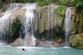
Erawan National Park
| Erawan National Park | |
|---|---|
IUCN category II (national park) | |
 Erawan Waterfall | |
 | |
| Location | Kanchanaburi Province, Thailand |
| Nearest city | Kanchanaburi |
| Coordinates | 14°23′N 99°07′E / 14.383°N 99.117°E |
| Area | 550 km2 (210 sq mi) |
| Established | 14 August 1975 [1] |
| Visitors | 650,852 (in 2019) |
| Governing body | Department of National Park, Wildlife and Plant Conservation (DNP) |
Erawan National Park is a national park in Kanchanaburi Province, Thailand. It is located in the Tenasserim Hills in the western part of Thailand. It covers an area of 550 square kilometers.[2]
Location[change | change source]
It is located in the Tenasserim Hills of Kanchanaburi Province. It is around 129 kilometers west of Bangkok.
History[change | change source]
It was established in June 1975 as the 12th national park of Thailand.
Geography[change | change source]
It is a part of the Tenasserim mountain range. It has mountains made of limestone which are between 165 and 996 meters high. There are four caves. They are called Mi Cave, Phartat Cave, Rua Cave and Wang Bahdan Cave.[3]
Wildlife[change | change source]
Hornbill and kingfisher are common birds that are seen here. It is home to over 120 species of birds and many animals.
Asian elephants, tigers, gibbon, and various types of deer are among the other animals found in Erawan National Park.
References[change | change source]
- ↑ [1] [bare URL PDF]
- ↑ "ข้อมูลพื้นที่อุทยานแห่งชาติ ที่ประกาศในราชกิจจานุบกษา 133 แห่ง" [National Park Area Information published in the 133 Government Gazettes]. Department of National Parks, Wildlife and Plant Conservation (in Thai). December 2020. Archived from the original on 3 November 2022. Retrieved 1 November 2022, no 12
{{cite web}}: CS1 maint: postscript (link) - ↑ Erawan National Park Archived December 8, 2006, at the Wayback Machine
