
Aude (river)
| Aude L'Aude | |
|---|---|
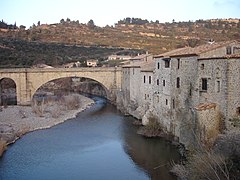
 The Aude at Carcassonne | |
.png) The Aude river (blue lines) in the Aude department (with red lines) | |
| Location | |
| Countries | France |
| Physical characteristics | |
| Source | |
| - location | Les Angles, Lac d'Aude, Massif du Carlit, Pyrénées, France |
| - elevation | 2,136 m (7,008 ft) |
| Mouth | |
| - location | Fleury/Vendres, France, Mediterranean Sea |
| - coordinates | 43°12′45″N 3°14′25″E / 43.21250°N 3.24028°E |
| - elevation | 0 m (0 ft) |
| Length | 224.1 km (139.2 mi)[1] |
| Basin size | 6,074 square kilometres (2,345 sq mi) total and 4,900 square kilometres (1,900 sq mi) above Coursan[3] |
| Discharge | |
| - average | 43.6 m3/s (1,540 cu ft/s) at Moussan[2] |
| Basin features | |
| Tributaries | |
| - left | the Cesse, the Fresquel, the Orbiel, the Argent-Double, the Trapel, the Sou de Val de Daigne |
| - right | the Orbieu, the Sals, the Lauquet |
The Aude is a river of southern French. It starts in the Pyrénées mountains and ends in the Mediterranean Sea. The Aude department is named after this river.
In Roman times, the Aude was called Atax by the Romans. In all likelihood the current name comes from gradual changes of Atax, a word borrowed from the Celtic atacos meaning "spirited" or "very fast"[4]
Geography[change | change source]
The Aude has a length of 224 km (139.2 mi), and a drainage basin with an area of approximately 6,074 km2 (2,345 sq mi).[5]
Its average yearly discharge (volume of water which passes through a section of the river per unit of time) is 41.40 cubic metres per second at Moussan.[6]
Course[change | change source]
The Aude starts in the Massif of Carlit at the Lac d'Aude at an elevation of 2,180 metres (7,150 ft) in the commune of Les Angles (Pyrénées-Orientales department).[7]
From the Pyrénées to Carcassonne, the river flows generally from south to north and then turns to the east. The river then flows into the Mediterranean Sea a few kilometres from Narbonne at Grau de Vendres (near Cabanes-de-Fleury) on the border between the departments of Aude and Hérault.[8]
The Aude flows through 1 region, 4 departments and 75 communes.[5] The main communes are:
- Occitanie region
Main tributaries[change | change source]
The main tributaries (30 km or more long) of the Aude river are:
- Left tributaries
- Right tributaries
Gallery[change | change source]
-
 The Aude at Matemale
 -
 The Aude at Axat
 -
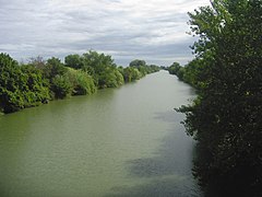 The Aude near its mouth at Salles-d'Aude
 -


Related pages[change | change source]
References[change | change source]
- ↑ The Aude Archived 2013-06-10 at the Wayback Machine, Sandre, consulted on 17 February 2013 (in French)
- ↑ Hydro Bank - The Aude at Moussan (1965-2009) Archived 2021-11-22 at the Wayback Machine, Ministry of Ecology, Sustainable Development and Energy, consulted on 17 February 2013 (in French)
- ↑ Hydro Bank - The Aude at Coursan Archived 2021-11-22 at the Wayback Machine, Ministry of Ecology, Sustainable Development and Energy, consulted on 17 February 2013 (in French)
- ↑ "Atacos / Atax / Attagus (Aude)" (in French). L'arbre celtique. Retrieved 20 July 2015.
- ↑ 5.0 5.1 "L'Aude (Y1--0200)" (in French). SANDRE - Portail national d'accès aux référentiels sur l'eau. Archived from the original on 10 June 2013. Retrieved 20 July 2015.
- ↑ "L'Aude à Moussan" (in French). Banque Hydro. Archived from the original on 22 November 2021. Retrieved 20 July 2015.
- ↑ "Source de l'Aude" (in French). Géoportail. Retrieved 20 July 2015.
- ↑ "Confluence de l'Aude" (in French). Géoportail. Retrieved 20 July 2015.
- ↑ "Le Rebenty (Y1100500)" (in French). SANDRE - Portail national d'accès aux référentiels sur l'eau. Archived from the original on 4 March 2016. Retrieved 20 July 2015.
- ↑ "Le Sou (Y1200500)" (in French). SANDRE - Portail national d'accès aux référentiels sur l'eau. Archived from the original on 4 March 2016. Retrieved 20 July 2015.
- ↑ "Le Fresquel (Y13-0400)" (in French). SANDRE - Portail national d'accès aux référentiels sur l'eau. Archived from the original on 3 March 2016. Retrieved 20 July 2015.
- ↑ "L'Orbiel (Y1410500)" (in French). SANDRE - Portail national d'accès aux référentiels sur l'eau. Archived from the original on 1 July 2013. Retrieved 20 July 2015.
- ↑ "L'Argent-Double (Y1430540)" (in French). SANDRE - Portail national d'accès aux référentiels sur l'eau. Archived from the original on 3 March 2016. Retrieved 20 July 2015.
- ↑ "La Cesse (Y1600500)" (in French). SANDRE - Portail national d'accès aux référentiels sur l'eau. Archived from the original on 3 March 2016. Retrieved 20 July 2015.
- ↑ "Le Lauquet (Y1220500)" (in French). SANDRE - Portail national d'accès aux référentiels sur l'eau. Archived from the original on 3 March 2016. Retrieved 20 July 2015.
- ↑ "L'Orbieu (Y15-0400)" (in French). SANDRE - Portail national d'accès aux référentiels sur l'eau. Archived from the original on 3 March 2016. Retrieved 20 July 2015.
Other websites[change | change source]
- Banque Hydro - Station Y1612020 - L'Aude à Moussan Archived 2015-02-19 at the Wayback Machine (in French)
| International | |
|---|---|
| National | |
| Other | |