Mableton, Georgia
Mableton, Georgia | |
|---|---|
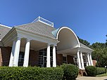
From top to bottom, left to right: a residential street in Mableton, Robert Mable's home built in 1843, the Mableton Post Office, the Atlanta skyline from Mt. Harmony Memorial Gardens in Mableton | |
 Location in Cobb County and the state of Georgia | |
Location within the Atlanta Metropolitan Area | |
| Coordinates: 33°49′06″N 84°34′34″W / 33.81833°N 84.57611°W | |
| State | |
| County | Cobb |
| Settled | September 11, 1843 |
| Incorporated (town) | August 19, 1912 |
| Disincorporated | August 17, 1916 |
| Incorporated (city) | May 11, 2023 |
| Founded by | Robert Mable |
| Area | |
| • Total | 20.5 sq mi (53.1 km2) |
| • Land | 20.4 sq mi (52.9 km2) |
| • Water | 0.1 sq mi (0.2 km2) |
| Elevation | 978 ft (298 m) |
| Population | |
| • Total | 40,834 |
| • Density | 2,000/sq mi (770/km2) |
| Time zone | UTC-5 (Eastern (EST)) |
| • Summer (DST) | UTC-4 (EDT) |
| ZIP code | 30126 |
| Area code | 770/678/404 |
| FIPS code | 13-48288[3] |
| GNIS feature ID | 0332295[4] |
| Website | mableton |
Mableton is a city in Cobb County, Georgia, United States. It became a city in 2023.[5] As of the 2020 census, 40,834 people lived in the area.[2]
References[change | change source]
- ↑ "2020 U.S. Gazetteer Files". United States Census Bureau. Retrieved December 18, 2021.
- ↑ 2.0 2.1 "QuickFacts: Mableton CDP, Georgia". United States Census Bureau. Retrieved April 2, 2024.
- ↑ "U.S. Census website". United States Census Bureau. Retrieved January 31, 2008.
- ↑ "US Board on Geographic Names". United States Geological Survey. October 25, 2007. Retrieved January 31, 2008.
- ↑ Dillon, Denise (November 9, 2022). "Voters choose to incorporate Mableton, making it Georgia's newest city". FOX 5 Atlanta. Archived from the original on December 24, 2023. Retrieved December 24, 2023.


