
Marmande
Marmande | |
|---|---|
Subprefecture and commune | |
 Cloister of the Our Lady church, Marmande | |
.svg) Coat of arms | |
Location of Marmande  | |
 Marmande  Marmande | |
| Coordinates: 44°30′N 0°10′E / 44.50°N 0.17°E | |
| Country | France |
| Region | Nouvelle-Aquitaine |
| Department | Lot-et-Garonne |
| Arrondissement | Marmande |
| Canton | Marmande-1 Marmande-2 |
| Intercommunality | Val de Garonne |
| Government | |
| • Mayor (2014–2020) | Daniel Benquet[1] |
| Area 1 | 45.06 km2 (17.40 sq mi) |
| Population (2014) | 17,748 |
| • Density | 390/km2 (1,000/sq mi) |
| Demonym | Marmandais |
| Time zone | UTC+01:00 (CET) |
| • Summer (DST) | UTC+02:00 (CEST) |
| INSEE/Postal code | 470157 /47200 |
| Elevation | 12–132 m (39–433 ft) (avg. 72 m or 236 ft) |
| Website | www.mairie-marmande.fr |
| 1 French Land Register data, which excludes lakes, ponds, glaciers > 1 km2 (0.386 sq mi or 247 acres) and river estuaries. | |
Marmande is a commune in southwestern France, in the region of Nouvelle-Aquitaine. It is a sub-prefecture of the Lot-et-Garonne department, capital of the arrondissement of Marmande. It is also the capital of 2 cantons in the department: Marmande-1 and Marmande-2.
Geography[change | change source]
Marmande is on the right side of the Garonne river, at about 64 km (40 mi) to the northwest of Agen and 71 km (44 mi) to the southwest of Bordeaux.
It has an area of 36.88 km2 (14.24 sq mi) and its average altitude is 72 m (236 ft); at the city hall, the altitude is 30 m (98 ft).[2]

|
Marmande is surrounded by the communes Beaupuy, Mauvezin-sur-Gupie, Escassefort, Virazeil, Saint-Pardoux-du-Breuil, Fourques-sur-Garonne, Montpouillan, Gaujac and Sainte-Bazeille.
Places next to Marmande | |
|---|---|
Climate[change | change source]
The climate of Marmande is an oceanic climate (Köppen climate classification Cfb), with mild winters and warm summers.
Population[change | change source]
The inhabitants of Marmande are known, in French, as Marmandais (women: Marmandaises).[3]
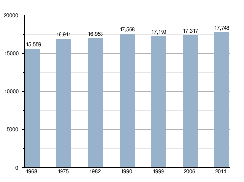
With a population of 17,748,[4] Marmande has a population density of 394 inhabitants/km2.
Evolution of the population in Marmande
Administration[change | change source]
Marmande is a subprefecture of the Lot-et-Garonne department since 1790. It is also the capital of the arrondissement of Marmande and the administrative centre (French: chef-lieu) of 2 cantons:[5]
- Marmande-1, formed with a part of Marmande and nine other communes, with 18,503 inhabitants (2014).
- Marmande-2, formed with a part of Marmande and ten other communes, with 17,833 inhabitants (2014).
It is part of the intercommunality Val de Garonne (French: Val de Garonne Agglomération).
Twin towns[change | change source]
Monuments and sites[change | change source]
- Église Notre-Dame de Marmande : Our Lady church and cloister built on the 13th century.
- Jardin du Cloître de Notre-Dame de Garonne (Garden of the Cloister of Our Lady of Garonne).[7]
Gallery[change | change source]
-
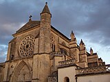 Notre-Dame de Marmande.
 -
 Cloister of Notre-Dame de Marmande.
 -
 Garden of Notre-Dame de Marmande.
 -
 Marmande town hall.


Related pages[change | change source]
References[change | change source]
- ↑ "Le Maire" (in French). Ville de Marmande. Archived from the original on 15 June 2017. Retrieved 25 April 2017.
- ↑ "City of Marmande". Map-France.com. Retrieved 21 March 2015.
- ↑ "Marmande (47180)" (in French). habitants.fr. Retrieved 21 March 2015.
- ↑ "Régions, départements, arrondissements, cantons et communes" (PDF). Populations légales 2014 (in French). Institut national de la statistique et des études économiques - INSEE. Retrieved 25 April 2017.
- ↑ "Commune de Marmande (47157)". Géographie administrative et d’étude (in French). Institut national de la statistique et des études économiques - INSEE. Retrieved 25 April 2017.
- ↑ "Jumelages" (in French). Ville de Marmande. Archived from the original on 15 June 2017. Retrieved 25 April 2017.
- ↑ "Jardin du cloître de Notre-Dame de Garonne" (in French). Comité des Parcs et Jardins de France. Retrieved 21 March 2015.
Other websites[change | change source]
- Ville Marmande - Official site (in French)
- Departamental Council of Lot-et-Garonne (in French)
- Prefecture official website Archived 2011-05-14 at the Wayback Machine (in French)
- Région Nouvelle-Aquitaine (in French)