
User:Immanuelle/Kabeshima
| This is a draft being worked on by Immanuelle. It may be too complex at the moment but she wants to get it ready to be an article someday. Others are free to edit it This page was last edited by Immanuelle (talk | contribs) 1 second ago. |
 | |
| Geography | |
|---|---|
| Location | Sea of Japan (Genkai Sea) |
| Coordinates | 33°33′20″N 129°53′0″E / 33.55556°N 129.88333°E |
| Area | 2.95 km2 (1.14 sq mi) |
| Coastline | 8 km (5 mi) |
| Additional information | |
| Time zone | |
Kabe Island, known in Japanese as Kabe-shima (加部島) is an island located in the Genkai Sea,[1] approximately 500 meters off the coast of Yobuko Port in Yobuko Town, Karatsu City, in the northern part of the Higashi Matsuura Peninsula . It is connected to Tonoura in Yobuko Town on the mainland by the Yobuko Bridge . It belongs to Karatsu City , Saga Prefecture, and its district name is Kabeshima, Yobuko Town, Karatsu City.
Kabe Island is located in Saga Prefecture in southwestern Japan, the island is approximately 900 km west of Tokyo, the country's capital. It covers 3.0 square kilometers.
It is an important island [1] [2] [3] [4]
The land of Kabe Shima is flat. [a] The highest point of the island is 92 meters above sea level. It covers 2.9 km from north to south and 1.9 km from east to west. [b]
The climate is temperate . The average temperature is 15 °C . The hottest month is August, with an average temperature of 24 °C, and the coldest January, with an average temperature of 8 °C. [3] The average rainfall is 2,403 millimeters per year. The wettest month is August, with 484 millimeters of rain, and the driest is January, with 43 millimeters. [4]

overview[change | change source]
The area of the island is approximately 2.68 km2
The population was 464 as of November 2022, having declined from 583 in 2010 and 762 in 1995.
It is located right in front of Yobuko Port and serves as a natural breakwater protecting the port from the rough waves of the Genkai Sea. The watershed lies to the far south of the island, while the highest peak, Mount Tendo, is located in the southwest.
On the other hand, the northern side of the island is a plateau with an expanse of flat land. The geology is basalt, and the northern coast consists of columnar jointed sea cliffs . [5]
There are two settlements: Kabeshima and Katashima. Along with fishing, such as yellowtail farming and squid fishing, agriculture is also thriving, with rice, vegetables, and citrus fruits being cultivated, and beef cattle being raised. Local specialties include amanatsu (Yobuko amanatsu) and amanatsu jelly made from it. [5]
It is part of Genkai Quasi-National Park . [6]
In 2009, the island's "farmland landscape protected by windbreaks" was selected as one of the "100 Best Villages of Japan " by the Asahi Shimbun Company and the Forest Culture Association. [7]
The early 6th century keyhole-shaped tumulus "Hyozuka Kofun" located in Suginohara Ranch in the northern part of the island is said to be the tomb of Emperor Yamato Takeru 's son, Prince Wakatake. Additionally, Tashima-jinja, which is mentioned in the Matsuura Kojiki and has within its grounds the Sayohime Shrine associated with the legend of Matsuura Sayohime, is said to be the oldest shrine in Saga Prefecture and is also a historic island that received special treatment from the Imperial Court during the time of the Japanese envoys to the Tang Dynasty.
traffic[change | change source]
The 727m-long Yobuko Bridge connects the southern part of the island with Tonoura in Yobuko Town on the mainland. There is a signpost for the Yobuko Bridge on National Route 204 in Yobuko Town, Karatsu City.
Showa Bus operates local buses and shared taxis that pass over the Yobuko Bridge and connect the Yobuko bus stop in downtown Yobuko with Kabeshima. There are bus stops on the island, at the foot of the Yobuko Bridge and on the east side of the island. It takes about 15 minutes from Sugimura, Kabeshima to Yobuko. At Yobuko, it connects with Showa Bus, which runs between Karatsu city center ( Karatsu Oteguchi Bus Center ) and Yobuko.
Climate[change | change source]
| ||||||||||||||||||||||||||||||||||||||||||||||||||||||||||||||||||||||||||||||||||||||||||||||||
Tourist attractions[change | change source]
- Tashima-jinja
- Sayohime Shrine
- Wind View Hill Park
- Suginohara Ranch
Gallery[change | change source]
-
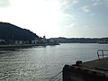
 Kabeshima Island seen from Sakigata in Yobuko, Karatsu - View 1
 -
 Kabeshima Island seen from Sakigata in Yobuko, Karatsu - View 2
 -
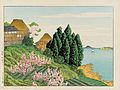 Artistic rendition of Hizen Kabeshima by Kawase Hasui
 -
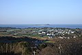 Rural landscape of Kabeshima from Kazeno-mieru-oka Park
 -
 Takashima and Kabeshima Islands seen from Sakigata in Yobuko, Karatsu
 -
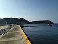
 Yobuko Port and Kabeshima Island
 -
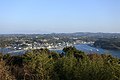 Yobuko Town as seen from Kazeno-mieru-oka Park
 -
 View of Tashima Shrine
 -
 Full view of Tashima Shrine


Footnotes[change | change source]
- ↑ Calculation from height data (DEM 3") from Viewfinder Panoramas.[2] The full algorithm is available here.
- ↑ Calculation from height data (DEM 3") from Viewfinder Panoramas.[2] The full algorithm is available here.
References[change | change source]
- ↑ 1.0 1.1 [[[:Template:Geonameslink]] Kabe Shima] sa [[[:Template:Geonamesabout]] Geonames.org (cc-by)]; post updated 2013-08-07; database download sa 2017-02-07
- ↑ 2.0 2.1 2.2 [[[:Template:Viewfinderlink]] "Viewfinder Panoramas Digital elevation Model"]. 2015-06-21.
{{cite web}}: Check|url=value (help) - ↑ 3.0 3.1 "NASA Earth Observations Data Set Index". NASA. Retrieved 30 Enero 2016.
{{cite web}}: Check date values in:|access-date=(help) - ↑ 4.0 4.1 "NASA Earth Observations: Rainfall (1 month - TRMM)". NASA/Tropical Rainfall Monitoring Mission. Retrieved 30 Enero 2016.
{{cite web}}: Check date values in:|access-date=(help) - ↑ 5.0 5.1 「加部島 世界大百科事典,日本大百科全書」、コトバンク、2015年9月5日閲覧
- ↑ 「玄海国定公園」佐賀県、2015年9月5日閲覧
- ↑ 「にほんの里100選 86. 加部島」、朝日新聞社・森林文化協会、2015年9月5日閲覧