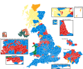
File:2017UKElectionMap.svg

Size of this PNG preview of this SVG file: 720 × 599 pixels. Other resolutions: 288 × 240 pixels | 577 × 480 pixels | 923 × 768 pixels | 1,230 × 1,024 pixels | 2,460 × 2,048 pixels | 1,248 × 1,039 pixels.
Original file (SVG file, nominally 1,248 × 1,039 pixels, file size: 5.36 MB)
File history
Click on a date/time to view the file as it appeared at that time.
| Date/Time | Thumbnail | Dimensions | User | Comment | |
|---|---|---|---|---|---|
| current | 15:45, 22 June 2019 |  | 1,248 × 1,039 (5.36 MB) | SD604 | Using the wiki colour for Sinn Féin. |
| 18:43, 25 May 2019 |  | 1,248 × 1,039 (5.36 MB) | Renamed user OCfxJKu7j2 | Minor fix of SNP colour and colour of Aberdeen North constituency. | |
| 00:17, 6 December 2017 |  | 1,248 × 1,039 (5.36 MB) | Renamed user OCfxJKu7j2 | Fixed back: Coatbridge, Chryston & Bellshill was a Labour gain from SNP | |
| 07:25, 3 November 2017 |  | 1,248 × 1,039 (5.36 MB) | Into oblivion | changed SNP colouring to official party colour | |
| 12:36, 2 November 2017 |  | 1,248 × 1,039 (5.36 MB) | Renamed user OCfxJKu7j2 | Renaming Welsh Valleys to en:South Wales | |
| 16:16, 13 June 2017 |  | 1,248 × 1,039 (5.36 MB) | Renamed user OCfxJKu7j2 | Making Belfast consistent with elsewhere and moving it out of the Irish Sea covering the Isle of Man. I think a discussion needs to be had about how many enlargements we do. Aberdeen is the 39th largest urban area in the UK after all, does that mean w... | |
| 12:13, 13 June 2017 |  | 1,248 × 1,039 (5.35 MB) | RaviC | More edits for rendering, added Aberdeen | |
| 21:52, 12 June 2017 |  | 1,248 × 1,039 (5.34 MB) | RaviC | colour | |
| 20:50, 12 June 2017 |  | 1,248 × 1,039 (5.34 MB) | RaviC | Enlarged Belfast | |
| 20:26, 9 June 2017 |  | 1,248 × 1,039 (5.33 MB) | Rosenzweig | Kensington now declared for Labour, see http://www.bbc.com/news/politics/constituencies/E14000768 |
File usage
The following page uses this file:
Global file usage
The following other wikis use this file:
- Usage on ar.wikipedia.org
- Usage on arz.wikipedia.org
- Usage on ca.wikipedia.org
- Usage on cs.wikipedia.org
- Usage on cy.wikipedia.org
- Usage on de.wikipedia.org
- Usage on eml.wikipedia.org
- Usage on en.wikipedia.org
- Brexit
- 2017 United Kingdom general election
- Candidates in the 2017 United Kingdom general election
- Wikipedia:Reference desk/Archives/Humanities/2017 June 9
- Wikipedia:Top 25 Report/June 4 to 10, 2017
- User:NebuchadnezzarHammurabi/sandbox
- User:Elect2Play/sandbox
- User:NMR42/sandbox
- User:Jasper0333/sandbox
- User talk:24.162.42.250/sandbox
- User:TheOfficially/sandbox
- User:Samhaz25/sandbox
- User:HoopaRoopa
- User:Generico456/sandbox
- User:TER Jack64/sandbox
- Usage on en.wiktionary.org
- Usage on es.wikipedia.org
- Usage on es.wikinews.org
- Usage on eu.wikipedia.org
- Usage on fa.wikipedia.org
- Usage on fi.wikipedia.org
- Usage on fr.wikipedia.org
- Usage on ga.wikipedia.org
- Usage on he.wikipedia.org
- Usage on hu.wikipedia.org
- Usage on id.wikipedia.org
- Usage on it.wikipedia.org
- Usage on ja.wikipedia.org
- Usage on ko.wikipedia.org
- Usage on kw.wikipedia.org
- Usage on lmo.wikipedia.org
- Usage on lv.wikipedia.org
- Usage on ms.wikipedia.org
- Usage on nl.wikipedia.org
- Usage on no.wikipedia.org
- Usage on pl.wikipedia.org
- Usage on pt.wikipedia.org
- Usage on ro.wikipedia.org
- Usage on ru.wikipedia.org
- Usage on ru.wikinews.org
View more global usage of this file.
