
File:Kent Cinque Ports.svg

Size of this PNG preview of this SVG file: 800 × 570 pixels. Other resolutions: 320 × 228 pixels | 640 × 456 pixels | 1,024 × 730 pixels | 1,280 × 913 pixels | 2,560 × 1,825 pixels | 1,700 × 1,212 pixels.
Original file (SVG file, nominally 1,700 × 1,212 pixels, file size: 163 KB)
| This is a file from the Wikimedia Commons. Information from its description page there is shown below. Commons is a freely licensed media file repository. You can help. |
Summary
| Description |
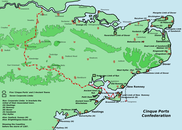
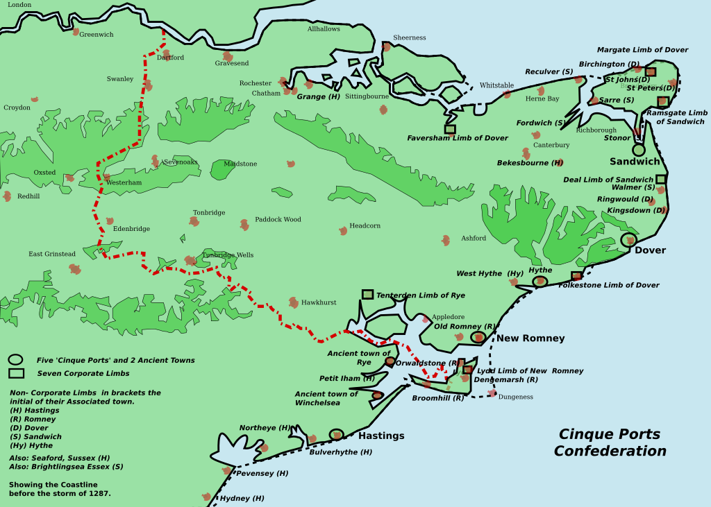
English: This ia a map of the Cinque Ports in Kent and Sussex. All seven of them and their 7 limbs and many of the associated limbs. In 1287, the storm caused the silting up of the channel of the River Rother. The map was inspired by Jessop, Kent History Illustrated- please contact me to inform me of omissions and errors. |
| Date | |
| Source | Own work |
| Author | Clem Rutter, Rochester, Kent. |
| Other versions | Derivative works of this file: Cinque Ports map.svg |
| SVG development |
Licensing
I, the copyright holder of this work, hereby publish it under the following licenses:

|
Permission is granted to copy, distribute and/or modify this document under the terms of the GNU Free Documentation License, Version 1.2 or any later version published by the Free Software Foundation; with no Invariant Sections, no Front-Cover Texts, and no Back-Cover Texts. A copy of the license is included in the section entitled GNU Free Documentation License. |
| This file is licensed under the Creative Commons Attribution-Share Alike 3.0 Unported license. | ||
| ||
| This licensing tag was added to this file as part of the GFDL licensing update. |
This file is licensed under the Creative Commons Attribution 2.5 Generic license.
- You are free:
- to share – to copy, distribute and transmit the work
- to remix – to adapt the work
- Under the following conditions:
- attribution – You must give appropriate credit, provide a link to the license, and indicate if changes were made. You may do so in any reasonable manner, but not in any way that suggests the licensor endorses you or your use.
You may select the license of your choice.
File history
Click on a date/time to view the file as it appeared at that time.
| Date/Time | Thumbnail | Dimensions | User | Comment | |
|---|---|---|---|---|---|
| current | 19:57, 8 October 2017 | | 1,700 × 1,212 (163 KB) | Ras67 | frames removed and cropped |
| 14:26, 25 June 2007 |  | 1,839 × 1,207 (182 KB) | ClemRutter | == Summary == {{Information |Description= This ia a map of the Cinque Ports in Kent and Sussex. All seven of them and their 7 limbs and many of the associated limbs. In 1287, the storm caused the silting up of the channel of the River Rother. The map was |
File usage
The following page uses this file:
Global file usage
The following other wikis use this file:
- Usage on ar.wikipedia.org
- Usage on cy.wikipedia.org
- Usage on da.wikipedia.org
- Usage on en.wikipedia.org
- Usage on eo.wikipedia.org
- Usage on es.wikipedia.org
- Usage on fi.wikipedia.org
- Usage on fr.wikipedia.org
- Usage on it.wikipedia.org
- Usage on ja.wikipedia.org
- Usage on ko.wikipedia.org
- Usage on mt.wikipedia.org
- Usage on nl.wikipedia.org
- Usage on no.wikipedia.org
- Usage on ru.wikipedia.org
- Usage on rw.wikipedia.org
- Usage on sh.wikipedia.org
- Usage on sl.wikipedia.org
- Usage on sv.wikipedia.org
- Usage on zh.wikipedia.org