
File:LimburgBGemeenten.png
LimburgBGemeenten.png (270 × 203 pixels, file size: 8 KB, MIME type: image/png)
| This is a file from the Wikimedia Commons. Information from its description page there is shown below. Commons is a freely licensed media file repository. You can help. |

|
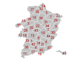
File:Municipalities Limburg Belgium Map - Number.svg is a vector version of this file. It should be used in place of this PNG file when not inferior.
File:LimburgBGemeenten.png → File:Municipalities Limburg Belgium Map - Number.svg
For more information, see Help:SVG. |
 |
| This work has been released into the public domain by its author, LennartBolks. This applies worldwide. In some countries this may not be legally possible; if so: |
|
1. Alken |
23. Kinrooi |
File history
Click on a date/time to view the file as it appeared at that time.
| Date/Time | Thumbnail | Dimensions | User | Comment | |
|---|---|---|---|---|---|
| current | 17:54, 13 December 2004 | | 270 × 203 (8 KB) | Walter | {{PD}} |
File usage
The following page uses this file:
Global file usage
The following other wikis use this file:
- Usage on ar.wikipedia.org
- Usage on br.wikipedia.org
- Usage on ca.wikipedia.org
- Usage on en.wikipedia.org
- Usage on es.wikipedia.org
- Usage on et.wikipedia.org
- Usage on eu.wikipedia.org
- Usage on fi.wikipedia.org
- Usage on gl.wikipedia.org
- Usage on hr.wikipedia.org
- Usage on hu.wikipedia.org
- Usage on id.wikipedia.org
- Usage on it.wikipedia.org
- Usage on ja.wikipedia.org
- Usage on ko.wikipedia.org
- Usage on la.wikipedia.org
- Usage on li.wikipedia.org
- Usage on nl.wikipedia.org
- Usage on oc.wikipedia.org
- Sint-Truiden
- Modèl:Comunas de la província de Limborg
- Alken (Belgica)
- As (Belgica)
- Beringen (Belgica)
- Bilzen
- Bocholt (Belgica)
- Borgloon
- Bree (Belgica)
- Diepenbeek
- Dilsen-Stokkem
- Genk
- Gingelom
- Halen
- Ham (Belgica)
- Hamont-Achel
- Hasselt (Belgica)
- Hechtel-Eksel
- Heers
- Herk-de-Stad
- Herstappe
- Heusden-Zolder
- Hoeselt
- Houthalen-Helchteren
- Kinrooi
- Kortessem
- Lanaken
- Leopoldsburg
View more global usage of this file.